ZIP Code: 47804, Terre Haute, IN
ZIP Code 47804 is located in Terre Haute, Indiana. Its detail State, County, City, Longitude, Latitude, Envelope Example, Population is as below.
ZIP Code 47804 Information

-
-
Country:
U.S. - United States
State:
County FIPS:
18167
County:
City:
City Type ?In many cases, a ZIP Code can have multiple "names", meaning cities, towns, or subdivisions, in its boundaries. However, it will ALWAYS have exactly 1 "default" name. D - Default - This is the "preferred" name - by the USPS - for a city. Each ZIP Code has one - and only one - "default" name. In most cases, this is what people who live in that area call the city as well. A - Acceptable - This name can be used for mailing purposes. Often times alternative names are large neighborhoods or sections of the city/town. In some cases a ZIP Code may have several "acceptable" names which is used to group towns under one ZIP Code. N - Not Acceptable - A "not acceptable" name is, in many cases, a nickname that residents give that location. According to the USPS, you should NOT send mail to that ZIP Code using the "not acceptable" name when mailing.:
D (Default)
ZIP Code:
47804
❓What does D (Default) mean? This is the "preferred" name - by the USPS - for a city. Each ZIP Code has one - and only one - "default" name. In most cases, this is what people who live in that area call the city as well.
-


-
Iconic US Landmark Legacy Designs
Get PNG, SVG, EPS, AI, PDF Versions at Just $0.1
 Download Now
-


ZipCodeCraft
ZIP Code 47804 Plus 4
ZIP Code 5 plus 4 is the extension of 5-digit zip code, It can be used to locate a more detailed location. The last four digits designate segment or one side of a street or an apartment. You can find the ZIP+4 code and corresponding address of the zip code 47804 below.
| ZIP Code 5 Plus 4 | Address |
|---|---|
| 47804-0323 | PO BOX 4323, TERRE HAUTE, IN |
| 47804-1000 | 3300 WHITCOMB ST, TERRE HAUTE, IN |
| 47804-1001 | 2901 N 3RD ST, TERRE HAUTE, IN |
| 47804-1002 | 2900 N 3RD ST, TERRE HAUTE, IN |
| 47804-1003 | 3001 N 3RD ST, TERRE HAUTE, IN |
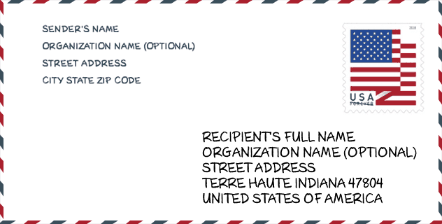
Envelope Example

This is an example of a US zip envelope. You can use a 5-digit zipcode or a detailed 9-digit zipcode to copy the mail in the following address format.
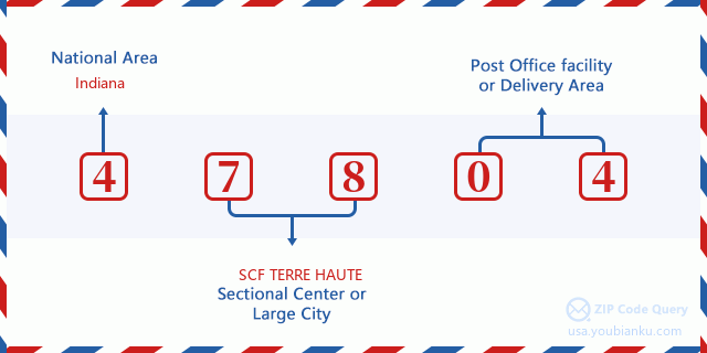
47804 Basic Meaning
What does each digit of ZIP Code 47804 stands for? The first digit designates a national area, which ranges from zero for the Northeast to nine for the far West. The 2-3 digits are the code of a sectional center facility in that region. The last two digits designate small post offices or postal zones.
Online Map

This is online map of the address Terre Haute, Indiana, United States. You may use button to move and zoom in / out. The map information is for reference only.
Hospital

This is the ZIP Code 47804 - Hospital page list. Its detail Hospital Name, Street, City, State, ZIP Code, Phone is as below.
| Name | Address | City | State | ZIP Code | Phone |
|---|---|---|---|---|---|
| HAMILTON CENTER INC | 620 8TH AVE | TERRE HAUTE | IN | 47804 | (812) 231-8285 |
| UNION HOSPITAL INC | 1606 N SEVENTH ST | TERRE HAUTE | IN | 47804 | (812) 238-7606 |
Museum

This is the ZIP Code 47804 - Museum page list. Its detail Museum Name, Street, City, State, ZIP Code, Phone is as below.
- Name: WABASH VALLEY RAILROADER MUSEUM
- Street: 1316 PLUM ST
- City: TERRE HAUTE
- State: IN
- ZIP Code: 47804
- Phone: (812) 238-9958
School

This is the ZIP Code 47804 - School page list. Its detail School Name, Address, City, State, ZIP Code is as below.
| School Name | Address | City | State | Grades | ZIP Code |
|---|---|---|---|---|---|
| Deming Early Learning Center | 1750 8th Av | Terre Haute | IN | UG | 47804 |
| Terre Haute North Vigo High School | 3434 Maple Av | Terre Haute | IN | UG | 47804 |
| Ouabache Elementary School | 501 Maple Ave | Terre Haute | IN | UG | 47804 |
Population for ZIP Code 47804

What is the total population in ZIP Code 47804? Below is detail information.
- Population for ZIP Code 47804: 10,958
- 2010 Population: 11,020
The 2020 demographic statistics are in progress. The current population in ZIP code 47804 is 10,958, and the population in 2010 is 11,020.
Gender

In all the statistical population, the male population is 5,274, the female population is 5,746.
- Male Population: 5,274
- Female Population: 5,746
Race

In all the statistical population, the male population is 5,274, the female population is 5,746.
- White Population: 10,236
- Black Population: 807
- Hispanic Population: 193
- Asian Population: 50
- Hawaiian Population: 15
- Indian Population: 103
- Other Population: 88
Age

In all the statistical population, the White population is 10,236, the Black population is 807, the Hispanic population is 193, the Asian population is 50, the Hawaiian population is 15, the Indian Ppopulation is 103 and Other population is 88.
- Age's Median: 37.7
- Median of male age: 34.9
- Median of female age: 40.0
Households for ZIP Code 47804
ZIP code 47804 has 4,534 households, with an average number of 2.37 persons per household. The average income per household in Zip code 47804 is 34,970 USD, and the average house value is 63,900 USD.
- Households Per Zipcode: 4,534
- Persons Per Household: 2.37
- Average House Value: 63,900
- Income Per Household: 34,970
Geographic

The latitude of the Zip code 47804 is 39.499717, the longitude is -87.391991, and the elevation is 485. It has land area of 6.577 square miles, and water area of 0.096 square miles. The time zone for ZIP code 47804 is Eastern (GMT -05:00). Daylight saving time should be observed in the area where the zip code is located.
- Latitude: 39.499717
- Longitude: -87.391991
- Elevation: 485
- Land Area: 6.577
- Water Area: 0.096
- Time Zone: Eastern (GMT -05:00)
- Region: Midwest
- Division: East North Central
- Day Light Saving: Y
Congressional District

The Congressional District for ZIP code 47804 is Indiana's 08th congressional district, the Congressional Land Area is 7255.39 square mile.
- Congressional District: 08th
- Congressional Land Area: 7255.39
Delivery

In the ZIP code 47804, there are 4,624 residential delivery mailboxes and centralized units, and 353 commercial delivery mailbox and centralized units, 4,191 single family deliveries and 335 multifamily deliveries, and the box count is 6,720. The main post office has city delivery carrier routes for the ZIP code 47804.
- Delivery Residential: 4,624
- Delivery Business: 353
- Delivery Total: 6,720
- Single Family Delivery Units: 4,191
- Multi Family Delivery Units: 335
- City Delivery Indicator: Y
Business

In ZIP code 47804, the number of business is 243, the number of employee is 7,345, the business first quarter payroll is 89,800,000 USD, the business annual payroll is 340,637,000 USD.
- Number Of Businesses: 243
- Number Of Employees: 7,345
- Business First Quarter Payroll: 89,800,000
- Business Annual Payroll: 340,637,000
Social Security Benefits

There are 2,600 beneficiaries with benefits in current-payment status for ZIP code 47804, of which 1,440 are retired workers, 655 are disabled workers, 195 are widow(er)s and parents, 55 are spouses and 255 are children. The number of beneficiaries aged 65 or older is 1,570. The total monthly benefits are 3,125,000 USD, of which 2,012,000 USD for retired workers, 249,000 USD for widow(er)s and parents.
- Total Number: 2,600
- Retired workers Number: 1,440
- Disabled workers Number: 655
- Widow(er)s and parents Number: 195
- Spouses Number: 55
- Children Number: 255
- All beneficiaries per month: 3,125,000
- Retired workers per month: 2,012,000
- Widow(er)s and parents per month: 249,000
- Number of beneficiaries aged 65 or older: 1,570


Add new comment