United States ZIP Code: 60018
This is the Illinois ZIP Code 60018 page list. Its detail State, County, City, Longitude, Latitude, Envelope Example, Population is as below.
ZIP Code 60018 Information

-
-
Country:
U.S. - United States
State:
State FIPS:
17
ZIP Code:
60018
ZIP Type:
S (Standard)
❓What does S (Standard) mean? A "standard" ZIP Code is what most people think of when they talk about ZIP Codes - essentially a town, city, or a division of a city that has mail service.
-


-
Iconic US Landmark Legacy Designs
Get PNG, SVG, EPS, AI, PDF Versions at Just $0.1
 Download Now
-


ZipCodeCraft
ZIP Code 60018 - City

This is the city information corresponding to 60018:
| State | County | City | City Type ?In many cases, a ZIP Code can have multiple "names", meaning cities, towns, or subdivisions, in its boundaries. However, it will ALWAYS have exactly 1 "default" name. D - Default - This is the "preferred" name - by the USPS - for a city. Each ZIP Code has one - and only one - "default" name. In most cases, this is what people who live in that area call the city as well. A - Acceptable - This name can be used for mailing purposes. Often times alternative names are large neighborhoods or sections of the city/town. In some cases a ZIP Code may have several "acceptable" names which is used to group towns under one ZIP Code. N - Not Acceptable - A "not acceptable" name is, in many cases, a nickname that residents give that location. According to the USPS, you should NOT send mail to that ZIP Code using the "not acceptable" name when mailing. | ZIP Code |
|---|---|---|---|---|
| IL | Cook | Des Plaines | D (Default) | 60018 |
| IL | Cook | Rosemont | A (Acceptable) | 60018 |
❓What does D (Default) mean? This is the "preferred" name - by the USPS - for a city. Each ZIP Code has one - and only one - "default" name. In most cases, this is what people who live in that area call the city as well.
❓What does A (Acceptable) mean? This name can be used for mailing purposes. Often times alternative names are large neighborhoods or sections of the city/town. In some cases a ZIP Code may have several "acceptable" names which is used to group towns under one ZIP Code.
ZIP Code 60018 Plus 4
ZIP Code 5 plus 4 is the extension of 5-digit zip code, It can be used to locate a more detailed location. The last four digits designate segment or one side of a street or an apartment. You can find the ZIP+4 code and corresponding address of the zip code 60018 below.
| ZIP Code 5 Plus 4 | Address |
|---|---|
| 60018-0501 | PO BOX 501, ROSEMONT, IL |
| 60018-0621 | PO BOX 621, ROSEMONT, IL |
| 60018-0751 | PO BOX 751, ROSEMONT, IL |
| 60018-0871 | PO BOX 871, ROSEMONT, IL |
| 60018-1100 | 257 DOVER DR #A , DES PLAINES, IL |
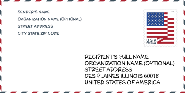
Envelope Example

This is an example of a US zip envelope. You can use a 5-digit zipcode or a detailed 9-digit zipcode to copy the mail in the following address format.
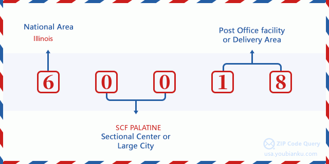
60018 Basic Meaning
What does each digit of ZIP Code 60018 stands for? The first digit designates a national area, which ranges from zero for the Northeast to nine for the far West. The 2-3 digits are the code of a sectional center facility in that region. The last two digits designate small post offices or postal zones.
Online Map

This is online map of the address Rosemont, Illinois, United States. You may use button to move and zoom in / out. The map information is for reference only.
Population for ZIP Code 60018

What is the total population in ZIP Code 60018? Below is detail information.
- Population for ZIP Code 60018: 30,787
- 2010 Population: 30,099
The 2020 demographic statistics are in progress. The current population in ZIP code 60018 is 30,787, and the population in 2010 is 30,099.
Gender

In all the statistical population, the male population is 15,031, the female population is 15,068.
- Male Population: 15,031
- Female Population: 15,068
Race

In all the statistical population, the male population is 15,031, the female population is 15,068.
- White Population: 22,487
- Black Population: 533
- Hispanic Population: 10,224
- Asian Population: 3,046
- Hawaiian Population: 52
- Indian Population: 467
- Other Population: 4,430
Age

In all the statistical population, the White population is 22,487, the Black population is 533, the Hispanic population is 10,224, the Asian population is 3,046, the Hawaiian population is 52, the Indian Ppopulation is 467 and Other population is 4,430.
- Age's Median: 37.8
- Median of male age: 36.0
- Median of female age: 39.7
Households for ZIP Code 60018
ZIP code 60018 has 10,361 households, with an average number of 2.86 persons per household. The average income per household in Zip code 60018 is 60,751 USD, and the average house value is 243,400 USD.
- Households Per Zipcode: 10,361
- Persons Per Household: 2.86
- Average House Value: 243,400
- Income Per Household: 60,751
Geographic

The latitude of the Zip code 60018 is 41.998622, the longitude is -87.898588, and the elevation is 644. It has land area of 16.416 square miles, and water area of 0.162 square miles. The time zone for ZIP code 60018 is Central (GMT -06:00). Daylight saving time should be observed in the area where the zip code is located.
- Latitude: 41.998622
- Longitude: -87.898588
- Elevation: 644
- Land Area: 16.416
- Water Area: 0.162
- Time Zone: Central (GMT -06:00)
- Region: Midwest
- Division: East North Central
- Day Light Saving: Y
Congressional District

The Congressional District for ZIP code 60018 is Illinois's 05th|08th|09th congressional district, the Congressional Land Area is 95.71|205.52|105.35 square mile.
- Congressional District: 05th|08th|09th
- Congressional Land Area: 95.71|205.52|105.35
Delivery

In the ZIP code 60018, there are 10,765 residential delivery mailboxes and centralized units, and 1,670 commercial delivery mailbox and centralized units, 6,716 single family deliveries and 2,720 multifamily deliveries, and the box count is 12,466. The main post office has city delivery carrier routes for the ZIP code 60018.
- Delivery Residential: 10,765
- Delivery Business: 1,670
- Delivery Total: 12,466
- Single Family Delivery Units: 6,716
- Multi Family Delivery Units: 2,720
- City Delivery Indicator: Y
Business

In ZIP code 60018, the number of business is 1,697, the number of employee is 52,383, the business first quarter payroll is 1,054,857,000 USD, the business annual payroll is 3,861,816,000 USD.
- Number Of Businesses: 1,697
- Number Of Employees: 52,383
- Business First Quarter Payroll: 1,054,857,000
- Business Annual Payroll: 3,861,816,000
Social Security Benefits

There are 5,120 beneficiaries with benefits in current-payment status for ZIP code 60018, of which 3,830 are retired workers, 505 are disabled workers, 280 are widow(er)s and parents, 200 are spouses and 305 are children. The number of beneficiaries aged 65 or older is 4,105. The total monthly benefits are 7,310,000 USD, of which 5,854,000 USD for retired workers, 415,000 USD for widow(er)s and parents.
- Total Number: 5,120
- Retired workers Number: 3,830
- Disabled workers Number: 505
- Widow(er)s and parents Number: 280
- Spouses Number: 200
- Children Number: 305
- All beneficiaries per month: 7,310,000
- Retired workers per month: 5,854,000
- Widow(er)s and parents per month: 415,000
- Number of beneficiaries aged 65 or older: 4,105


Add new comment