United States ZIP Code: 00667
This is the Puerto Rico ZIP Code 00667 page list. Its detail State, County, City, Longitude, Latitude, Envelope Example, Population is as below.
, highlighting postal theme with ZIP code 00667, showcasing bioluminescent bay, La Parguera village, Laguna Cartagena National Wildlife Refuge, Lajas flag, and postal elements in a colorful modern style.")
ZIP Code 00667 Information

-
-
Country:
U.S. - United States
State:
State FIPS:
72
ZIP Code:
00667
ZIP Type:
S (Standard)
❓What does S (Standard) mean? A "standard" ZIP Code is what most people think of when they talk about ZIP Codes - essentially a town, city, or a division of a city that has mail service.
-


-
Iconic US Landmark Legacy Designs
Get PNG, SVG, EPS, AI, PDF Versions at Just $0.1
 Download Now
-


ZipCodeCraft
ZIP Code 00667 - City

This is the city information corresponding to 00667:
| State | County | City | City Type ?In many cases, a ZIP Code can have multiple "names", meaning cities, towns, or subdivisions, in its boundaries. However, it will ALWAYS have exactly 1 "default" name. D - Default - This is the "preferred" name - by the USPS - for a city. Each ZIP Code has one - and only one - "default" name. In most cases, this is what people who live in that area call the city as well. A - Acceptable - This name can be used for mailing purposes. Often times alternative names are large neighborhoods or sections of the city/town. In some cases a ZIP Code may have several "acceptable" names which is used to group towns under one ZIP Code. N - Not Acceptable - A "not acceptable" name is, in many cases, a nickname that residents give that location. According to the USPS, you should NOT send mail to that ZIP Code using the "not acceptable" name when mailing. | ZIP Code |
|---|---|---|---|---|
| PR | Lajas | Alts De San Blas | N (Not Acceptable) | 00667 |
| PR | Lajas | Bda Nicolin Perez | N (Not Acceptable) | 00667 |
| PR | Lajas | Bda Tomei | N (Not Acceptable) | 00667 |
| PR | Lajas | Est De Lajas | N (Not Acceptable) | 00667 |
| PR | Lajas | Est Del Parra | N (Not Acceptable) | 00667 |
| PR | Lajas | Ext El Valle 2 | N (Not Acceptable) | 00667 |
| PR | Lajas | Jard De Lajas | N (Not Acceptable) | 00667 |
| PR | Lajas | Lajas | D (Default) | 00667 |
| PR | Lajas | Parq Real | N (Not Acceptable) | 00667 |
| PR | Lajas | Urb El Valle | N (Not Acceptable) | 00667 |
| PR | Lajas | Urb Linda Vista | N (Not Acceptable) | 00667 |
❓What does D (Default) mean? This is the "preferred" name - by the USPS - for a city. Each ZIP Code has one - and only one - "default" name. In most cases, this is what people who live in that area call the city as well.
❓What does N (Not Acceptable) mean? A "not acceptable" name is, in many cases, a nickname that residents give that location. According to the USPS, you should NOT send mail to that ZIP Code using the "not acceptable" name when mailing.
ZIP Code 00667 Plus 4
ZIP Code 5 plus 4 is the extension of 5-digit zip code, It can be used to locate a more detailed location. The last four digits designate segment or one side of a street or an apartment. You can find the ZIP+4 code and corresponding address of the zip code 00667 below.
| ZIP Code 5 Plus 4 | Address |
|---|---|
| 00667-0001 | PO BOX 1, LAJAS, PR |
| 00667-0121 | PO BOX 121, LAJAS, PR |
| 00667-0221 | PO BOX 221, LAJAS, PR |
| 00667-0341 | PO BOX 341, LAJAS, PR |
| 00667-0421 | PO BOX 421, LAJAS, PR |
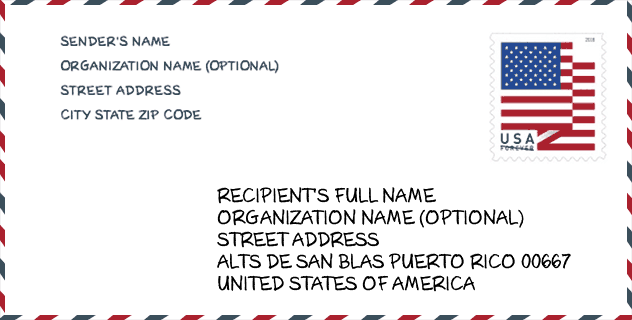
Envelope Example

This is an example of a US zip envelope. You can use a 5-digit zipcode or a detailed 9-digit zipcode to copy the mail in the following address format.
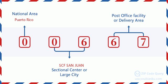
00667 Basic Meaning
What does each digit of ZIP Code 00667 stands for? The first digit designates a national area, which ranges from zero for the Northeast to nine for the far West. The 2-3 digits are the code of a sectional center facility in that region. The last two digits designate small post offices or postal zones.
Online Map

This is online map of the address Urb Linda Vista, Puerto Rico, United States. You may use button to move and zoom in / out. The map information is for reference only.
School

This is the ZIP Code 00667 - School page list. Its detail School Name, Address, City, State, ZIP Code is as below.
| School Name | Address | City | State | Grades | ZIP Code |
|---|---|---|---|---|---|
| LUIS MUNOZ RIVERA | CALLE 65 INFANTERIA ESQ DAVILA | LAJAS | PR | UG | 00667 |
| ROSENDO MATIENZO CINTRON | CARR 117 KM 5.3 BO LAJAS ARRIBA | LAJAS | PR | UG | 00667 |
| RAMON OLIVARES | CARR 303 CALLE AMAPOLA BO OLIVARES | LAJAS | PR | UG | 00667 |
| SU JUAN CANCIO ORTIZ DE LA RENTA | CARR 101 KM 7 HM 6 BO PALMAREJO | LAJAS | PR | UG | 00667 |
| ELEMENTAL URBANA NUEVA | AVE FLAMBOYAN #233 | LAJAS | PR | UG | 00667 |
| JOSE RODRIGUEZ DE SOTO | AVE LOS VETERANOS #40 BO ENSENADA | LAJAS | PR | UG | 00667 |
| LEONIDES MORALES RODRIGUEZ | CALLE SANTA ROSA #20 | LAJAS | PR | UG | 00667 |
Population for ZIP Code 00667

What is the total population in ZIP Code 00667? Below is detail information.
- Population for ZIP Code 00667: 16,194
- 2010 Population: 25,968
The 2020 demographic statistics are in progress. The current population in ZIP code 00667 is 16,194, and the population in 2010 is 25,968.
Gender

In all the statistical population, the male population is 12,713, the female population is 13,255.
- Male Population: 12,713
- Female Population: 13,255
Race

In all the statistical population, the male population is 12,713, the female population is 13,255.
- White Population: 21,345
- Black Population: 1,625
- Hispanic Population: 25,793
- Asian Population: 36
- Hawaiian Population: 11
- Indian Population: 107
- Other Population: 3,337
Age

In all the statistical population, the White population is 21,345, the Black population is 1,625, the Hispanic population is 25,793, the Asian population is 36, the Hawaiian population is 11, the Indian Ppopulation is 107 and Other population is 3,337.
- Age's Median: 39.8
- Median of male age: 37.8
- Median of female age: 41.6
Households for ZIP Code 00667
ZIP code 00667 has 9,762 households, with an average number of 2.65 persons per household. The average income per household in Zip code 00667 is 13,766 USD, and the average house value is 89,000 USD.
- Households Per Zipcode: 9,762
- Persons Per Household: 2.65
- Average House Value: 89,000
- Income Per Household: 13,766
Geographic

The latitude of the Zip code 00667 is 18.010034, the longitude is -67.022630, and the elevation is 22. It has land area of 60.314 square miles, and water area of 10.908 square miles. The time zone for ZIP code 00667 is Atlantic (GMT -04:00). Daylight saving time should be observed in the area where the zip code is located.
- Latitude: 18.010034
- Longitude: -67.022630
- Elevation: 22
- Land Area: 60.314
- Water Area: 10.908
- Time Zone: Atlantic (GMT -04:00)
- Day Light Saving: N
Delivery

In the ZIP code 00667, there are 6,111 residential delivery mailboxes and centralized units, and 248 commercial delivery mailbox and centralized units, 5,063 single family deliveries and 569 multifamily deliveries, and the box count is 8,480. The main post office has city delivery carrier routes for the ZIP code 00667.
- Delivery Residential: 6,111
- Delivery Business: 248
- Delivery Total: 8,480
- Single Family Delivery Units: 5,063
- Multi Family Delivery Units: 569
- City Delivery Indicator: Y


Add new comment