ZIP Code: 04039, Gray, ME
ZIP Code 04039 is located in Gray, Maine. Its detail State, County, City, Longitude, Latitude, Envelope Example, Population is as below.
 depicting retro airmail envelope with '04039' ZIP code and symbolic portrayal of the first woolen mill in America, symbolizing Gray's historical significance. Includes Maine state flag elements - a moose under a tall pine tree, farmer and sailor representing state's traditional reliance on agriculture and sea, topped with the state motto 'I Lead' North Star. Cleverly integrates elements symbolizing Cumberland County cultural heritage like local landmarks or unique human-made cultural features. Adorned with a typical American postage stamp and postmark, enhancing postal theme. Vibrant and modern illustration designed for web use, capturing the essence of the region's history, culture, and postal identity.")
ZIP Code 04039 Information

-
-
Country:
U.S. - United States
State:
County FIPS:
23005
City:
Area Code:
City Type ?In many cases, a ZIP Code can have multiple "names", meaning cities, towns, or subdivisions, in its boundaries. However, it will ALWAYS have exactly 1 "default" name. D - Default - This is the "preferred" name - by the USPS - for a city. Each ZIP Code has one - and only one - "default" name. In most cases, this is what people who live in that area call the city as well. A - Acceptable - This name can be used for mailing purposes. Often times alternative names are large neighborhoods or sections of the city/town. In some cases a ZIP Code may have several "acceptable" names which is used to group towns under one ZIP Code. N - Not Acceptable - A "not acceptable" name is, in many cases, a nickname that residents give that location. According to the USPS, you should NOT send mail to that ZIP Code using the "not acceptable" name when mailing.:
D (Default)
ZIP Code:
04039
❓What does D (Default) mean? This is the "preferred" name - by the USPS - for a city. Each ZIP Code has one - and only one - "default" name. In most cases, this is what people who live in that area call the city as well.
-


-
Iconic US Landmark Legacy Designs
Get PNG, SVG, EPS, AI, PDF Versions at Just $0.1
 Download Now
-


ZipCodeCraft
ZIP Code 04039 Plus 4
ZIP Code 5 plus 4 is the extension of 5-digit zip code, It can be used to locate a more detailed location. The last four digits designate segment or one side of a street or an apartment. You can find the ZIP+4 code and corresponding address of the zip code 04039 below.
| ZIP Code 5 Plus 4 | Address |
|---|---|
| 04039-0001 | PO BOX 1, GRAY, ME |
| 04039-0121 | PO BOX 121, GRAY, ME |
| 04039-0135 | 1301 BRALEAD RD, GRAY, ME |
| 04039-0141 | PO BOX 141, GRAY, ME |
| 04039-0241 | PO BOX 241, GRAY, ME |
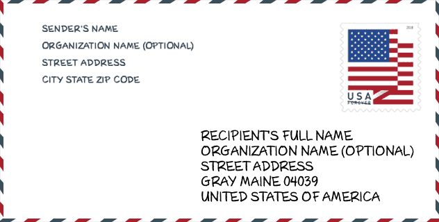
Envelope Example

This is an example of a US zip envelope. You can use a 5-digit zipcode or a detailed 9-digit zipcode to copy the mail in the following address format.
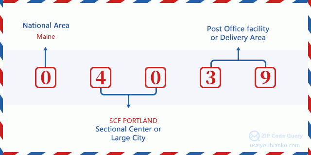
04039 Basic Meaning
What does each digit of ZIP Code 04039 stands for? The first digit designates a national area, which ranges from zero for the Northeast to nine for the far West. The 2-3 digits are the code of a sectional center facility in that region. The last two digits designate small post offices or postal zones.
Online Map

This is online map of the address Gray, Maine, United States. You may use button to move and zoom in / out. The map information is for reference only.
Library

This is the ZIP Code 04039 - Library page list. Its detail Library Name, Address, City, State, ZIP Code, Phone is as below.
- Name: GRAY PUBLIC LIBRARY
- Address: 5 HANCOCK STREET
- City: GRAY
- State: ME - Maine
- ZIP Code: 04039
- Phone: (207) 657-4110
School

This is the ZIP Code 04039 - School page list. Its detail School Name, Address, City, State, ZIP Code is as below.
| School Name | Address | City | State | Grades | ZIP Code |
|---|---|---|---|---|---|
| Gray-New Gloucester High School | 10 Libby Hill Road | Gray | ME | UG | 04039 |
| Russell School | 8 Gray Park | Gray | ME | UG | 04039 |
| Gray-New Gloucester Middle School | 31 Libby Hill Road | Gray | ME | UG | 04039 |
| Fiddlehead School of Arts & Science | 25 Shaker Rd | Gray | ME | UG | 04039 |
Population for ZIP Code 04039

What is the total population in ZIP Code 04039? Below is detail information.
- Population for ZIP Code 04039: 7,884
- 2010 Population: 7,422
The 2020 demographic statistics are in progress. The current population in ZIP code 04039 is 7,884, and the population in 2010 is 7,422.
Gender

In all the statistical population, the male population is 3,691, the female population is 3,731.
- Male Population: 3,691
- Female Population: 3,731
Race

In all the statistical population, the male population is 3,691, the female population is 3,731.
- White Population: 7,296
- Black Population: 82
- Hispanic Population: 65
- Asian Population: 54
- Hawaiian Population: 8
- Indian Population: 58
- Other Population: 20
Age

In all the statistical population, the White population is 7,296, the Black population is 82, the Hispanic population is 65, the Asian population is 54, the Hawaiian population is 8, the Indian Ppopulation is 58 and Other population is 20.
- Age's Median: 40.2
- Median of male age: 39.8
- Median of female age: 40.7
Households for ZIP Code 04039
ZIP code 04039 has 3,008 households, with an average number of 2.47 persons per household. The average income per household in Zip code 04039 is 71,855 USD, and the average house value is 220,000 USD.
- Households Per Zipcode: 3,008
- Persons Per Household: 2.47
- Average House Value: 220,000
- Income Per Household: 71,855
Geographic

The latitude of the Zip code 04039 is 43.887580, the longitude is -70.341074, and the elevation is 247. It has land area of 40.66 square miles, and water area of 0.927 square miles. The time zone for ZIP code 04039 is Eastern (GMT -05:00). Daylight saving time should be observed in the area where the zip code is located.
- Latitude: 43.887580
- Longitude: -70.341074
- Elevation: 247
- Land Area: 40.66
- Water Area: 0.927
- Time Zone: Eastern (GMT -05:00)
- Region: Northeast
- Division: New England
- Day Light Saving: Y
Congressional District

The Congressional District for ZIP code 04039 is Maine's 1st congressional district, the Congressional Land Area is 3285.52 square mile.
- Congressional District: 1st
- Congressional Land Area: 3285.52
Delivery

In the ZIP code 04039, there are 3,192 residential delivery mailboxes and centralized units, and 120 commercial delivery mailbox and centralized units, 2,636 single family deliveries and 43 multifamily deliveries, and the box count is 5,019. The main post office does not have city delivery carrier routes for the ZIP code 04039.
- Delivery Residential: 3,192
- Delivery Business: 120
- Delivery Total: 5,019
- Single Family Delivery Units: 2,636
- Multi Family Delivery Units: 43
- City Delivery Indicator: N
Business

In ZIP code 04039, the number of business is 233, the number of employee is 1,609, the business first quarter payroll is 13,530,000 USD, the business annual payroll is 60,362,000 USD.
- Number Of Businesses: 233
- Number Of Employees: 1,609
- Business First Quarter Payroll: 13,530,000
- Business Annual Payroll: 60,362,000


Add new comment