ZIP Code: 76012, Arlington, TX
ZIP Code 76012 is located in Arlington, Texas. Its detail State, County, City, Longitude, Latitude, Envelope Example, Population is as below.
ZIP Code 76012 Information

-
-
Country:
U.S. - United States
State:
County FIPS:
48439
County:
City:
City Type ?In many cases, a ZIP Code can have multiple "names", meaning cities, towns, or subdivisions, in its boundaries. However, it will ALWAYS have exactly 1 "default" name. D - Default - This is the "preferred" name - by the USPS - for a city. Each ZIP Code has one - and only one - "default" name. In most cases, this is what people who live in that area call the city as well. A - Acceptable - This name can be used for mailing purposes. Often times alternative names are large neighborhoods or sections of the city/town. In some cases a ZIP Code may have several "acceptable" names which is used to group towns under one ZIP Code. N - Not Acceptable - A "not acceptable" name is, in many cases, a nickname that residents give that location. According to the USPS, you should NOT send mail to that ZIP Code using the "not acceptable" name when mailing.:
D (Default)
ZIP Code:
76012
❓What does D (Default) mean? This is the "preferred" name - by the USPS - for a city. Each ZIP Code has one - and only one - "default" name. In most cases, this is what people who live in that area call the city as well.
-


-
Iconic US Landmark Legacy Designs
Get PNG, SVG, EPS, AI, PDF Versions at Just $0.1
 Download Now
-


ZipCodeCraft
ZIP Code 76012 Plus 4
ZIP Code 5 plus 4 is the extension of 5-digit zip code, It can be used to locate a more detailed location. The last four digits designate segment or one side of a street or an apartment. You can find the ZIP+4 code and corresponding address of the zip code 76012 below.
| ZIP Code 5 Plus 4 | Address |
|---|---|
| 76012-0001 | PO BOX 120001, ARLINGTON, TX |
| 76012-0121 | PO BOX 120121, ARLINGTON, TX |
| 76012-0241 | PO BOX 120241, ARLINGTON, TX |
| 76012-0361 | PO BOX 120361, ARLINGTON, TX |
| 76012-0481 | PO BOX 120481, ARLINGTON, TX |
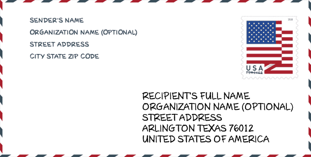
Envelope Example

This is an example of a US zip envelope. You can use a 5-digit zipcode or a detailed 9-digit zipcode to copy the mail in the following address format.
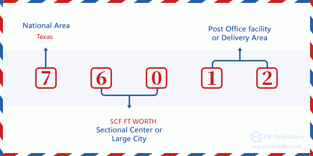
76012 Basic Meaning
What does each digit of ZIP Code 76012 stands for? The first digit designates a national area, which ranges from zero for the Northeast to nine for the far West. The 2-3 digits are the code of a sectional center facility in that region. The last two digits designate small post offices or postal zones.
Online Map

This is online map of the address Arlington, Texas, United States. You may use button to move and zoom in / out. The map information is for reference only.
Hospital

This is the ZIP Code 76012 - Hospital page list. Its detail Hospital Name, Street, City, State, ZIP Code, Phone is as below.
| Name | Address | City | State | ZIP Code | Phone |
|---|---|---|---|---|---|
| TEXAS HEALTH ARLINGTON MEMORIAL HOSPITAL | 800 W RANDOL MILL RD | ARLINGTON | TX | 76012 | (817) 548-6100 |
| TEXAS HEALTH HEART & VASCULAR HOSPITAL ARLINGTON | 811 WRIGHT STREET | ARLINGTON | TX | 76012 | (817) 960-3500 |
School

This is the ZIP Code 76012 - School page list. Its detail School Name, Address, City, State, ZIP Code is as below.
| School Name | Address | City | State | Grades | ZIP Code |
|---|---|---|---|---|---|
| TURNING POINT SECONDARY SCHOOL | 2209 N DAVIS DR | ARLINGTON | TX | UG | 76012 |
| COMMUNITY BASED PK | 423 N CENTER ST | ARLINGTON | TX | UG | 76012 |
| WIMBISH WORLD LANGUAGE ACADEMY | 1601 WRIGHT ST | ARLINGTON | TX | UG | 76012 |
Population for ZIP Code 76012

What is the total population in ZIP Code 76012? Below is detail information.
- Population for ZIP Code 76012: 26,377
- 2010 Population: 25,689
The 2020 demographic statistics are in progress. The current population in ZIP code 76012 is 26,377, and the population in 2010 is 25,689.
Gender

In all the statistical population, the male population is 12,376, the female population is 13,313.
- Male Population: 12,376
- Female Population: 13,313
Race

In all the statistical population, the male population is 12,376, the female population is 13,313.
- White Population: 19,338
- Black Population: 3,360
- Hispanic Population: 4,973
- Asian Population: 1,071
- Hawaiian Population: 77
- Indian Population: 389
- Other Population: 2,272
Age

In all the statistical population, the White population is 19,338, the Black population is 3,360, the Hispanic population is 4,973, the Asian population is 1,071, the Hawaiian population is 77, the Indian Ppopulation is 389 and Other population is 2,272.
- Age's Median: 39.9
- Median of male age: 38.4
- Median of female age: 41.3
Households for ZIP Code 76012
ZIP code 76012 has 10,124 households, with an average number of 2.50 persons per household. The average income per household in Zip code 76012 is 61,214 USD, and the average house value is 186,300 USD.
- Households Per Zipcode: 10,124
- Persons Per Household: 2.50
- Average House Value: 186,300
- Income Per Household: 61,214
Geographic

The latitude of the Zip code 76012 is 32.764106, the longitude is -97.146875, and the elevation is 486. It has land area of 8.17 square miles, and water area of 0.071 square miles. The time zone for ZIP code 76012 is Central (GMT -06:00). Daylight saving time should be observed in the area where the zip code is located.
- Latitude: 32.764106
- Longitude: -97.146875
- Elevation: 486
- Land Area: 8.17
- Water Area: 0.071
- Time Zone: Central (GMT -06:00)
- Region: South
- Division: West South Central
- Day Light Saving: Y
Congressional District

The Congressional District for ZIP code 76012 is Texas's 06th|33th congressional district, the Congressional Land Area is 2148.41|211.94 square mile.
- Congressional District: 06th|33th
- Congressional Land Area: 2148.41|211.94
Delivery

In the ZIP code 76012, there are 10,551 residential delivery mailboxes and centralized units, and 781 commercial delivery mailbox and centralized units, 8,052 single family deliveries and 1,420 multifamily deliveries, and the box count is 14,008. The main post office has city delivery carrier routes for the ZIP code 76012.
- Delivery Residential: 10,551
- Delivery Business: 781
- Delivery Total: 14,008
- Single Family Delivery Units: 8,052
- Multi Family Delivery Units: 1,420
- City Delivery Indicator: Y
Business

In ZIP code 76012, the number of business is 614, the number of employee is 7,443, the business first quarter payroll is 78,803,000 USD, the business annual payroll is 348,633,000 USD.
- Number Of Businesses: 614
- Number Of Employees: 7,443
- Business First Quarter Payroll: 78,803,000
- Business Annual Payroll: 348,633,000
Social Security Benefits

There are 5,065 beneficiaries with benefits in current-payment status for ZIP code 76012, of which 3,830 are retired workers, 470 are disabled workers, 335 are widow(er)s and parents, 245 are spouses and 185 are children. The number of beneficiaries aged 65 or older is 4,235. The total monthly benefits are 7,861,000 USD, of which 6,405,000 USD for retired workers, 513,000 USD for widow(er)s and parents.
- Total Number: 5,065
- Retired workers Number: 3,830
- Disabled workers Number: 470
- Widow(er)s and parents Number: 335
- Spouses Number: 245
- Children Number: 185
- All beneficiaries per month: 7,861,000
- Retired workers per month: 6,405,000
- Widow(er)s and parents per month: 513,000
- Number of beneficiaries aged 65 or older: 4,235


Add new comment