United States ZIP Code: 07017
This is the New Jersey ZIP Code 07017 page list. Its detail State, County, City, Longitude, Latitude, Envelope Example, Population is as below.

ZIP Code 07017 Information

-
-
Country:
U.S. - United States
State:
State FIPS:
34
ZIP Code:
07017
ZIP Type:
S (Standard)
❓What does S (Standard) mean? A "standard" ZIP Code is what most people think of when they talk about ZIP Codes - essentially a town, city, or a division of a city that has mail service.
-


-
Iconic US Landmark Legacy Designs
Get PNG, SVG, EPS, AI, PDF Versions at Just $0.1
 Download Now
-


ZipCodeCraft
ZIP Code 07017 - City

This is the city information corresponding to 07017:
| State | County | City | City Type ?In many cases, a ZIP Code can have multiple "names", meaning cities, towns, or subdivisions, in its boundaries. However, it will ALWAYS have exactly 1 "default" name. D - Default - This is the "preferred" name - by the USPS - for a city. Each ZIP Code has one - and only one - "default" name. In most cases, this is what people who live in that area call the city as well. A - Acceptable - This name can be used for mailing purposes. Often times alternative names are large neighborhoods or sections of the city/town. In some cases a ZIP Code may have several "acceptable" names which is used to group towns under one ZIP Code. N - Not Acceptable - A "not acceptable" name is, in many cases, a nickname that residents give that location. According to the USPS, you should NOT send mail to that ZIP Code using the "not acceptable" name when mailing. | ZIP Code |
|---|---|---|---|---|
| NJ | Essex | Ampere | N (Not Acceptable) | 07017 |
| NJ | Essex | Doddtown | N (Not Acceptable) | 07017 |
| NJ | Essex | East Orange | D (Default) | 07017 |
❓What does D (Default) mean? This is the "preferred" name - by the USPS - for a city. Each ZIP Code has one - and only one - "default" name. In most cases, this is what people who live in that area call the city as well.
❓What does N (Not Acceptable) mean? A "not acceptable" name is, in many cases, a nickname that residents give that location. According to the USPS, you should NOT send mail to that ZIP Code using the "not acceptable" name when mailing.
ZIP Code 07017 Plus 4
ZIP Code 5 plus 4 is the extension of 5-digit zip code, It can be used to locate a more detailed location. The last four digits designate segment or one side of a street or an apartment. You can find the ZIP+4 code and corresponding address of the zip code 07017 below.
| ZIP Code 5 Plus 4 | Address |
|---|---|
| 07017-0800 | 275 PROSPECT ST #12M , EAST ORANGE, NJ |
| 07017-0801 | 275 PROSPECT ST #14L , EAST ORANGE, NJ |
| 07017-0802 | 275 PROSPECT ST #12L , EAST ORANGE, NJ |
| 07017-0803 | 234 PROSPECT ST, EAST ORANGE, NJ |
| 07017-1000 | 6 GLENWOOD AVE #00000021 , EAST ORANGE, NJ |
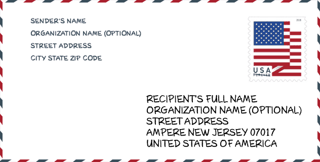
Envelope Example

This is an example of a US zip envelope. You can use a 5-digit zipcode or a detailed 9-digit zipcode to copy the mail in the following address format.
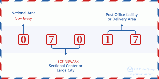
07017 Basic Meaning
What does each digit of ZIP Code 07017 stands for? The first digit designates a national area, which ranges from zero for the Northeast to nine for the far West. The 2-3 digits are the code of a sectional center facility in that region. The last two digits designate small post offices or postal zones.
Online Map

This is online map of the address East Orange, New Jersey, United States. You may use button to move and zoom in / out. The map information is for reference only.
Library

This is the ZIP Code 07017 - Library page list. Its detail Library Name, Address, City, State, ZIP Code, Phone is as below.
| Name | Address | City | State | ZIP Code | Phone |
|---|---|---|---|---|---|
| AMPERE BRANCH | 39 AMPERE PLAZA | EAST ORANGE | NJ | 07017 | (201) 266-5610 |
| ELMWOOD BRANCH | 317 S. CLINTON ST. | EAST ORANGE | NJ | 07017 | (201) 266-5620 |
| FRANKLIN BRANCH | 192 DODD STREET | EAST ORANGE | NJ | 07017 | (201) 266-5630 |
School

This is the ZIP Code 07017 - School page list. Its detail School Name, Address, City, State, ZIP Code is as below.
| School Name | Address | City | State | Grades | ZIP Code |
|---|---|---|---|---|---|
| East Orange Community Charter School | 99 WASHINGTON STREET | EAST ORANGE | NJ | UG | 07017 |
| Johnnie L. Cochran Jr. Academy | 190 MIDLAND AVENUE | EAST ORANGE | NJ | UG | 07017 |
| Althea Gibson Academy | 490 WILLIAM STREET | EAST ORANGE | NJ | UG | 07017 |
| Wahlstrom Early Childhood Academy | 340 PROSPECT STREET | EAST ORANGE | NJ | UG | 07017 |
| East Orange Campus High School | 344 PROSPECT STREET | EAST ORANGE | NJ | UG | 07017 |
| Cicely L. Tyson Community Elementary School | 45 North Arlington Street | EAST ORANGE | NJ | UG | 07017 |
| Cicely L. Tyson Community Middle/High School | 35 Winans Street | EAST ORANGE | NJ | UG | 07017 |
Population for ZIP Code 07017

What is the total population in ZIP Code 07017? Below is detail information.
- Population for ZIP Code 07017: 37,894
- 2010 Population: 35,945
The 2020 demographic statistics are in progress. The current population in ZIP code 07017 is 37,894, and the population in 2010 is 35,945.
Gender

In all the statistical population, the male population is 16,198, the female population is 19,747.
- Male Population: 16,198
- Female Population: 19,747
Race

In all the statistical population, the male population is 16,198, the female population is 19,747.
- White Population: 2,085
- Black Population: 32,200
- Hispanic Population: 3,100
- Asian Population: 384
- Hawaiian Population: 93
- Indian Population: 369
- Other Population: 1,815
Age

In all the statistical population, the White population is 2,085, the Black population is 32,200, the Hispanic population is 3,100, the Asian population is 384, the Hawaiian population is 93, the Indian Ppopulation is 369 and Other population is 1,815.
- Age's Median: 35.6
- Median of male age: 33.3
- Median of female age: 37.4
Households for ZIP Code 07017
ZIP code 07017 has 13,826 households, with an average number of 2.53 persons per household. The average income per household in Zip code 07017 is 44,805 USD, and the average house value is 217,300 USD.
- Households Per Zipcode: 13,826
- Persons Per Household: 2.53
- Average House Value: 217,300
- Income Per Household: 44,805
Geographic

The latitude of the Zip code 07017 is 40.772240, the longitude is -74.206592, and the elevation is 142. It has land area of 2.252 square miles, and water area of 0 square miles. The time zone for ZIP code 07017 is Eastern (GMT -05:00). Daylight saving time should be observed in the area where the zip code is located.
- Latitude: 40.772240
- Longitude: -74.206592
- Elevation: 142
- Land Area: 2.252
- Water Area: 0
- Time Zone: Eastern (GMT -05:00)
- Region: Northeast
- Division: Middle Atlantic
- Day Light Saving: Y
Congressional District

The Congressional District for ZIP code 07017 is New Jersey's 10th congressional district, the Congressional Land Area is 75.92 square mile.
- Congressional District: 10th
- Congressional Land Area: 75.92
Delivery

In the ZIP code 07017, there are 14,978 residential delivery mailboxes and centralized units, and 485 commercial delivery mailbox and centralized units, 6,535 single family deliveries and 8,104 multifamily deliveries, and the box count is 15,650. The main post office has city delivery carrier routes for the ZIP code 07017.
- Delivery Residential: 14,978
- Delivery Business: 485
- Delivery Total: 15,650
- Single Family Delivery Units: 6,535
- Multi Family Delivery Units: 8,104
- City Delivery Indicator: Y
Business

In ZIP code 07017, the number of business is 277, the number of employee is 3,093, the business first quarter payroll is 32,200,000 USD, the business annual payroll is 129,871,000 USD.
- Number Of Businesses: 277
- Number Of Employees: 3,093
- Business First Quarter Payroll: 32,200,000
- Business Annual Payroll: 129,871,000


Add new comment