United States ZIP Code: 00610
This is the Puerto Rico ZIP Code 00610 page list. Its detail State, County, City, Longitude, Latitude, Envelope Example, Population is as below.

ZIP Code 00610 Information

-
-
Country:
U.S. - United States
State:
State FIPS:
72
ZIP Code:
00610
ZIP Type:
S (Standard)
❓What does S (Standard) mean? A "standard" ZIP Code is what most people think of when they talk about ZIP Codes - essentially a town, city, or a division of a city that has mail service.
-


-
Iconic US Landmark Legacy Designs
Get PNG, SVG, EPS, AI, PDF Versions at Just $0.1
 Download Now
-


ZipCodeCraft
ZIP Code 00610 - City

This is the city information corresponding to 00610:
| State | County | City | City Type ?In many cases, a ZIP Code can have multiple "names", meaning cities, towns, or subdivisions, in its boundaries. However, it will ALWAYS have exactly 1 "default" name. D - Default - This is the "preferred" name - by the USPS - for a city. Each ZIP Code has one - and only one - "default" name. In most cases, this is what people who live in that area call the city as well. A - Acceptable - This name can be used for mailing purposes. Often times alternative names are large neighborhoods or sections of the city/town. In some cases a ZIP Code may have several "acceptable" names which is used to group towns under one ZIP Code. N - Not Acceptable - A "not acceptable" name is, in many cases, a nickname that residents give that location. According to the USPS, you should NOT send mail to that ZIP Code using the "not acceptable" name when mailing. | ZIP Code |
|---|---|---|---|---|
| PR | Anasco | Anasco | D (Default) | 00610 |
| PR | Anasco | Brisas De Anasco | N (Not Acceptable) | 00610 |
| PR | Anasco | Est De Valle Verde | N (Not Acceptable) | 00610 |
| PR | Anasco | Jard De Anasco | N (Not Acceptable) | 00610 |
| PR | Anasco | Paseo Del Valle | N (Not Acceptable) | 00610 |
| PR | Anasco | Repto Daguey | N (Not Acceptable) | 00610 |
| PR | Anasco | Sect Sanchez | N (Not Acceptable) | 00610 |
| PR | Anasco | Urb Los Arboles | N (Not Acceptable) | 00610 |
| PR | Anasco | Urb San Antonio | N (Not Acceptable) | 00610 |
| PR | Anasco | Urb Valle Real | N (Not Acceptable) | 00610 |
❓What does D (Default) mean? This is the "preferred" name - by the USPS - for a city. Each ZIP Code has one - and only one - "default" name. In most cases, this is what people who live in that area call the city as well.
❓What does N (Not Acceptable) mean? A "not acceptable" name is, in many cases, a nickname that residents give that location. According to the USPS, you should NOT send mail to that ZIP Code using the "not acceptable" name when mailing.
ZIP Code 00610 Plus 4
ZIP Code 5 plus 4 is the extension of 5-digit zip code, It can be used to locate a more detailed location. The last four digits designate segment or one side of a street or an apartment. You can find the ZIP+4 code and corresponding address of the zip code 00610 below.
| ZIP Code 5 Plus 4 | Address |
|---|---|
| 00610-0001 | PO BOX 1, ANASCO, PR |
| 00610-0101 | PO BOX 101, ANASCO, PR |
| 00610-0181 | PO BOX 181, ANASCO, PR |
| 00610-0301 | PO BOX 301, ANASCO, PR |
| 00610-0421 | PO BOX 421, ANASCO, PR |
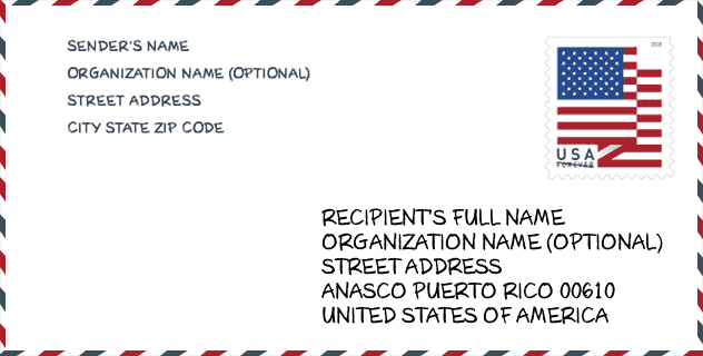
Envelope Example

This is an example of a US zip envelope. You can use a 5-digit zipcode or a detailed 9-digit zipcode to copy the mail in the following address format.
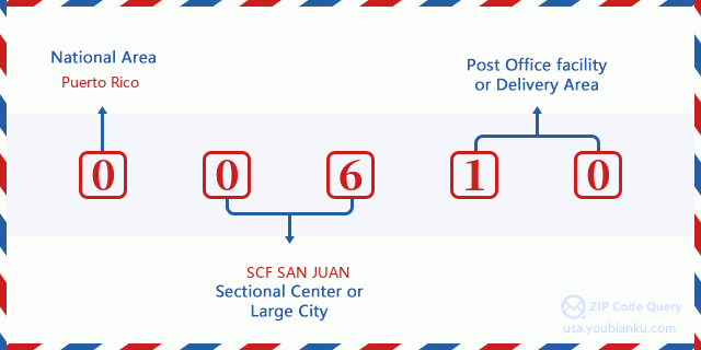
00610 Basic Meaning
What does each digit of ZIP Code 00610 stands for? The first digit designates a national area, which ranges from zero for the Northeast to nine for the far West. The 2-3 digits are the code of a sectional center facility in that region. The last two digits designate small post offices or postal zones.
Online Map

This is online map of the address Urb Valle Real, Puerto Rico, United States. You may use button to move and zoom in / out. The map information is for reference only.
School

This is the ZIP Code 00610 - School page list. Its detail School Name, Address, City, State, ZIP Code is as below.
| School Name | Address | City | State | Grades | ZIP Code |
|---|---|---|---|---|---|
| CARMEN CASASUS MARTI (ELEM URBANA) | CARR. 405 KM.0 HM. 9 BO. CARRERAS | ANASCO | PR | UG | 00610 |
| ANTONIO GONZALEZ SUAREZ (ESPECIALIZADA) | CARR. 402 KM 6 BO DAGUEY | ANASCO | PR | UG | 00610 |
| ISABEL SUAREZ | CALLE 65 INFANTERIA | ANASCO | PR | UG | 00610 |
| ESCUELA ESPECIALIZADA BILINGUE ALCIDES FIGUEROA | CALLE MARIA MONAGAS | ANASCO | PR | UG | 00610 |
| ESPINO | CARR.109 KM.5 HM.0 BO ESPINO | ANASCO | PR | UG | 00610 |
| LUIS MUNOZ MARIN | CARR. 402 KM. 1 HM.4 BO.MARIAS | ANASCO | PR | 09-12 | 00610 |
Population for ZIP Code 00610

What is the total population in ZIP Code 00610? Below is detail information.
- Population for ZIP Code 00610: 15,902
- 2010 Population: 29,016
The 2020 demographic statistics are in progress. The current population in ZIP code 00610 is 15,902, and the population in 2010 is 29,016.
Gender

In all the statistical population, the male population is 14,104, the female population is 14,912.
- Male Population: 14,104
- Female Population: 14,912
Race

In all the statistical population, the male population is 14,104, the female population is 14,912.
- White Population: 24,510
- Black Population: 2,654
- Hispanic Population: 28,789
- Asian Population: 57
- Hawaiian Population: 31
- Indian Population: 200
- Other Population: 2,494
Age

In all the statistical population, the White population is 24,510, the Black population is 2,654, the Hispanic population is 28,789, the Asian population is 57, the Hawaiian population is 31, the Indian Ppopulation is 200 and Other population is 2,494.
- Age's Median: 38.1
- Median of male age: 36.3
- Median of female age: 39.5
Households for ZIP Code 00610
ZIP code 00610 has 10,836 households, with an average number of 2.67 persons per household. The average income per household in Zip code 00610 is 19,309 USD, and the average house value is 88,600 USD.
- Households Per Zipcode: 10,836
- Persons Per Household: 2.67
- Average House Value: 88,600
- Income Per Household: 19,309
Geographic

The latitude of the Zip code 00610 is 18.294649, the longitude is -67.130034, and the elevation is 161. It has land area of 35.913 square miles, and water area of 1.611 square miles. The time zone for ZIP code 00610 is Atlantic (GMT -04:00). Daylight saving time should be observed in the area where the zip code is located.
- Latitude: 18.294649
- Longitude: -67.130034
- Elevation: 161
- Land Area: 35.913
- Water Area: 1.611
- Time Zone: Atlantic (GMT -04:00)
- Day Light Saving: N
Delivery

In the ZIP code 00610, there are 5,956 residential delivery mailboxes and centralized units, and 205 commercial delivery mailbox and centralized units, 4,791 single family deliveries and 454 multifamily deliveries, and the box count is 8,303. The main post office has city delivery carrier routes for the ZIP code 00610.
- Delivery Residential: 5,956
- Delivery Business: 205
- Delivery Total: 8,303
- Single Family Delivery Units: 4,791
- Multi Family Delivery Units: 454
- City Delivery Indicator: Y


Add new comment