United States ZIP Code: 00685
This is the Puerto Rico ZIP Code 00685 page list. Its detail State, County, City, Longitude, Latitude, Envelope Example, Population is as below.

ZIP Code 00685 Information

-
-
Country:
U.S. - United States
State:
State FIPS:
72
ZIP Code:
00685
ZIP Type:
S (Standard)
❓What does S (Standard) mean? A "standard" ZIP Code is what most people think of when they talk about ZIP Codes - essentially a town, city, or a division of a city that has mail service.
-


-
Iconic US Landmark Legacy Designs
Get PNG, SVG, EPS, AI, PDF Versions at Just $0.1
 Download Now
-


ZipCodeCraft
ZIP Code 00685 - City

This is the city information corresponding to 00685:
| State | County | City | City Type ?In many cases, a ZIP Code can have multiple "names", meaning cities, towns, or subdivisions, in its boundaries. However, it will ALWAYS have exactly 1 "default" name. D - Default - This is the "preferred" name - by the USPS - for a city. Each ZIP Code has one - and only one - "default" name. In most cases, this is what people who live in that area call the city as well. A - Acceptable - This name can be used for mailing purposes. Often times alternative names are large neighborhoods or sections of the city/town. In some cases a ZIP Code may have several "acceptable" names which is used to group towns under one ZIP Code. N - Not Acceptable - A "not acceptable" name is, in many cases, a nickname that residents give that location. According to the USPS, you should NOT send mail to that ZIP Code using the "not acceptable" name when mailing. | ZIP Code |
|---|---|---|---|---|
| PR | San Sebastian | Bda Chinto Rodon | N (Not Acceptable) | 00685 |
| PR | San Sebastian | Bda Estalingrado | N (Not Acceptable) | 00685 |
| PR | San Sebastian | Bda Paralelo 38 | N (Not Acceptable) | 00685 |
| PR | San Sebastian | Bda Pueblo Nuevo | N (Not Acceptable) | 00685 |
| PR | San Sebastian | Bda Tablastilla | N (Not Acceptable) | 00685 |
| PR | San Sebastian | Colinas Verdes | N (Not Acceptable) | 00685 |
| PR | San Sebastian | Comunidad Gonzalez | N (Not Acceptable) | 00685 |
| PR | San Sebastian | Ext Villa Rita | N (Not Acceptable) | 00685 |
| PR | San Sebastian | Jard Guatemala | N (Not Acceptable) | 00685 |
| PR | San Sebastian | Repto Pin Mendez | N (Not Acceptable) | 00685 |
| PR | San Sebastian | San Sebastian | D (Default) | 00685 |
| PR | San Sebastian | Urb Chinto Rodon | N (Not Acceptable) | 00685 |
| PR | San Sebastian | Urb El Culebrina | N (Not Acceptable) | 00685 |
| PR | San Sebastian | Urb El Guayabal | N (Not Acceptable) | 00685 |
| PR | San Sebastian | Urb La Estancia | N (Not Acceptable) | 00685 |
| PR | San Sebastian | Urb Los Alamos | N (Not Acceptable) | 00685 |
| PR | San Sebastian | Urb Olivencia | N (Not Acceptable) | 00685 |
| PR | San Sebastian | Urb Pedro T Labayen | N (Not Acceptable) | 00685 |
| PR | San Sebastian | Urb Pepino | N (Not Acceptable) | 00685 |
| PR | San Sebastian | Urb Venturini | N (Not Acceptable) | 00685 |
| PR | San Sebastian | Valle Verde | N (Not Acceptable) | 00685 |
| PR | San Sebastian | Villa Rita | N (Not Acceptable) | 00685 |
| PR | San Sebastian | Villas De Piedra Blanca | N (Not Acceptable) | 00685 |
❓What does D (Default) mean? This is the "preferred" name - by the USPS - for a city. Each ZIP Code has one - and only one - "default" name. In most cases, this is what people who live in that area call the city as well.
❓What does N (Not Acceptable) mean? A "not acceptable" name is, in many cases, a nickname that residents give that location. According to the USPS, you should NOT send mail to that ZIP Code using the "not acceptable" name when mailing.
ZIP Code 00685 Plus 4
ZIP Code 5 plus 4 is the extension of 5-digit zip code, It can be used to locate a more detailed location. The last four digits designate segment or one side of a street or an apartment. You can find the ZIP+4 code and corresponding address of the zip code 00685 below.
| ZIP Code 5 Plus 4 | Address |
|---|---|
| 00685-0001 | PO BOX 1, SAN SEBASTIAN, PR |
| 00685-0121 | PO BOX 121, SAN SEBASTIAN, PR |
| 00685-0241 | PO BOX 241, SAN SEBASTIAN, PR |
| 00685-0361 | PO BOX 361, SAN SEBASTIAN, PR |
| 00685-0481 | PO BOX 481, SAN SEBASTIAN, PR |
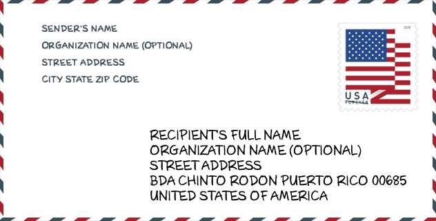
Envelope Example

This is an example of a US zip envelope. You can use a 5-digit zipcode or a detailed 9-digit zipcode to copy the mail in the following address format.
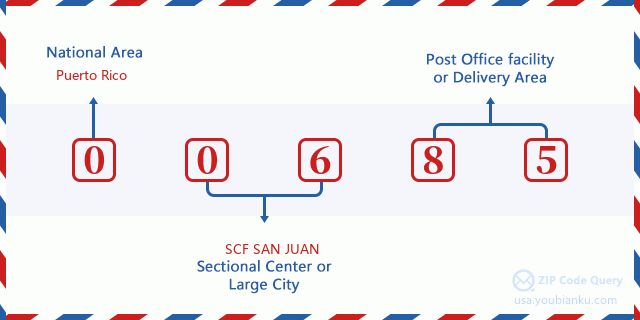
00685 Basic Meaning
What does each digit of ZIP Code 00685 stands for? The first digit designates a national area, which ranges from zero for the Northeast to nine for the far West. The 2-3 digits are the code of a sectional center facility in that region. The last two digits designate small post offices or postal zones.
Online Map

This is online map of the address Villas De Piedra Blanca, Puerto Rico, United States. You may use button to move and zoom in / out. The map information is for reference only.
University

This is the ZIP Code 00685 - University page list. Its detail university Name, Street, City, State, ZIP Code, Phone is as below.
| Name | Street | City | State | ZIP Code | Phone |
| EDP University of Puerto Rico Inc-San Sebastian | Betances # 49 | San Sebastian | PR | 00685 | (787) 896-2137 |
School
This is the ZIP Code 00685 - School page list. Its detail School Name, Address, City, State, ZIP Code is as below.
| School Name | Address | City | State | Grades | ZIP Code |
|---|---|---|---|---|---|
| MANUEL MENDEZ LICIAGA | CARR 125 KM 19 BO GUATEMALA | SAN SEBASTIAN | PR | UG | 00685 |
| RAMON MARIA TORRES | AVE EMERITO ESTRADA CARRETERA 111 | SAN SEBASTIAN | PR | UG | 00685 |
| AURORA MENDEZ CHARNECO | CALLE PEDRO ALBISUS CAMPOS | SAN SEBASTIAN | PR | UG | 00685 |
| AUREA FUENTES MENDEZ (CALABAZAS INFANTES) | CARR 435 KM 2 HM 3 | SAN SEBASTIAN | PR | UG | 00685 |
| SU BERNALDO MENDEZ JIMENEZ | CARR 125 KM 1 HM 5 BO HATO ARRIBA | SAN SEBASTIAN | PR | UG | 00685 |
| SU MAXIMINO A. SALAS | CARR 111 KM 29.2 BO JUNCAL | SAN SEBASTIAN | PR | UG | 00685 |
| SU CARMELO SERRANO CUBANO | CARR 445 KM 3 HM 6 BO SALTOS | SAN SEBASTIAN | PR | UG | 00685 |
| EMILIO SCHARON RODRIGUEZ | CARR. 111 KM.1.9 BO.HOYAMALA | SAN SEBASTIAN | PR | UG | 00685 |
| ERNESTINA MENDEZ | CARR.111KM.17HM 5 BO. BAHONAMEY | SAN SEBASTIAN | PR | UG | 00685 |
| PATRIA LATORRE RAMIREZ | CARR.111KM.23HM.2BO. PIEDRAS BLANCA | SAN SEBASTIAN | PR | 09-12 | 00685 |
Population for ZIP Code 00685

What is the total population in ZIP Code 00685? Below is detail information.
- Population for ZIP Code 00685: 28,871
- 2010 Population: 42,831
The 2020 demographic statistics are in progress. The current population in ZIP code 00685 is 28,871, and the population in 2010 is 42,831.
Gender

In all the statistical population, the male population is 20,921, the female population is 21,910.
- Male Population: 20,921
- Female Population: 21,910
Race

In all the statistical population, the male population is 20,921, the female population is 21,910.
- White Population: 38,831
- Black Population: 1,939
- Hispanic Population: 42,538
- Asian Population: 53
- Hawaiian Population: 18
- Indian Population: 330
- Other Population: 2,854
Age

In all the statistical population, the White population is 38,831, the Black population is 1,939, the Hispanic population is 42,538, the Asian population is 53, the Hawaiian population is 18, the Indian Ppopulation is 330 and Other population is 2,854.
- Age's Median: 38.9
- Median of male age: 37.4
- Median of female age: 40.3
Households for ZIP Code 00685
ZIP code 00685 has 16,190 households, with an average number of 2.64 persons per household. The average income per household in Zip code 00685 is 14,617 USD, and the average house value is 97,500 USD.
- Households Per Zipcode: 16,190
- Persons Per Household: 2.64
- Average House Value: 97,500
- Income Per Household: 14,617
Geographic

The latitude of the Zip code 00685 is 18.316188, the longitude is -66.974973, and the elevation is 448. It has land area of 77.533 square miles, and water area of 0.795 square miles. The time zone for ZIP code 00685 is Atlantic (GMT -04:00). Daylight saving time should be observed in the area where the zip code is located.
- Latitude: 18.316188
- Longitude: -66.974973
- Elevation: 448
- Land Area: 77.533
- Water Area: 0.795
- Time Zone: Atlantic (GMT -04:00)
- Day Light Saving: N
Delivery

In the ZIP code 00685, there are 10,936 residential delivery mailboxes and centralized units, and 457 commercial delivery mailbox and centralized units, 8,100 single family deliveries and 1,798 multifamily deliveries, and the box count is 14,443. The main post office has city delivery carrier routes for the ZIP code 00685.
- Delivery Residential: 10,936
- Delivery Business: 457
- Delivery Total: 14,443
- Single Family Delivery Units: 8,100
- Multi Family Delivery Units: 1,798
- City Delivery Indicator: Y


Add new comment