United States ZIP Code: 01040
This is the Massachusetts ZIP Code 01040 page list. Its detail State, County, City, Longitude, Latitude, Envelope Example, Population is as below.
ZIP Code 01040 Information

-
-
Country:
U.S. - United States
State:
State FIPS:
25
Area Code:
ZIP Code:
01040
ZIP Type:
S (Standard)
❓What does S (Standard) mean? A "standard" ZIP Code is what most people think of when they talk about ZIP Codes - essentially a town, city, or a division of a city that has mail service.
-


-
Iconic US Landmark Legacy Designs
Get PNG, SVG, EPS, AI, PDF Versions at Just $0.1
 Download Now
-


ZipCodeCraft
ZIP Code 01040 - City

This is the city information corresponding to 01040:
| State | County | City | City Type ?In many cases, a ZIP Code can have multiple "names", meaning cities, towns, or subdivisions, in its boundaries. However, it will ALWAYS have exactly 1 "default" name. D - Default - This is the "preferred" name - by the USPS - for a city. Each ZIP Code has one - and only one - "default" name. In most cases, this is what people who live in that area call the city as well. A - Acceptable - This name can be used for mailing purposes. Often times alternative names are large neighborhoods or sections of the city/town. In some cases a ZIP Code may have several "acceptable" names which is used to group towns under one ZIP Code. N - Not Acceptable - A "not acceptable" name is, in many cases, a nickname that residents give that location. According to the USPS, you should NOT send mail to that ZIP Code using the "not acceptable" name when mailing. | ZIP Code |
|---|---|---|---|---|
| MA | Hampden | Halyoke | N (Not Acceptable) | 01040 |
| MA | Hampden | Holyoke | D (Default) | 01040 |
❓What does D (Default) mean? This is the "preferred" name - by the USPS - for a city. Each ZIP Code has one - and only one - "default" name. In most cases, this is what people who live in that area call the city as well.
❓What does N (Not Acceptable) mean? A "not acceptable" name is, in many cases, a nickname that residents give that location. According to the USPS, you should NOT send mail to that ZIP Code using the "not acceptable" name when mailing.
ZIP Code 01040 Plus 4
ZIP Code 5 plus 4 is the extension of 5-digit zip code, It can be used to locate a more detailed location. The last four digits designate segment or one side of a street or an apartment. You can find the ZIP+4 code and corresponding address of the zip code 01040 below.
| ZIP Code 5 Plus 4 | Address |
|---|---|
| 01040-1000 | 29 ARDEN ST, HOLYOKE, MA |
| 01040-1001 | 15 EDBERT DR, HOLYOKE, MA |
| 01040-1002 | 1 EDBERT DR, HOLYOKE, MA |
| 01040-1003 | 95 EDBERT DR, HOLYOKE, MA |
| 01040-1004 | 54 EDBERT DR, HOLYOKE, MA |
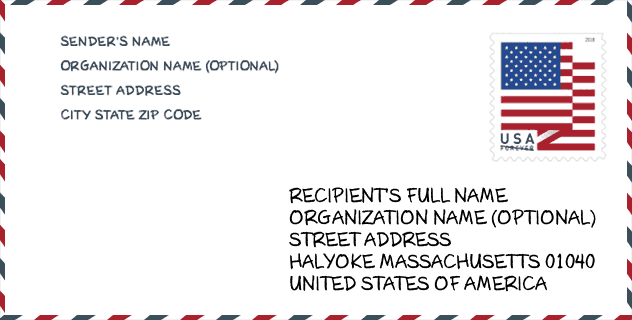
Envelope Example

This is an example of a US zip envelope. You can use a 5-digit zipcode or a detailed 9-digit zipcode to copy the mail in the following address format.
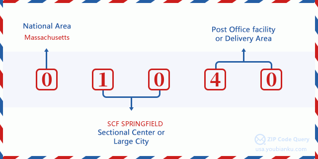
01040 Basic Meaning
What does each digit of ZIP Code 01040 stands for? The first digit designates a national area, which ranges from zero for the Northeast to nine for the far West. The 2-3 digits are the code of a sectional center facility in that region. The last two digits designate small post offices or postal zones.
Online Map

This is online map of the address Holyoke, Massachusetts, United States. You may use button to move and zoom in / out. The map information is for reference only.
University

This is the ZIP Code 01040 - University page list. Its detail university Name, Street, City, State, ZIP Code, Phone is as below.
| Name | Street | City | State | ZIP Code | Phone |
| Holyoke Community College | 303 Homestead Ave | Holyoke | MA | 01040 | (413) 552-2000 |
Hospital

This is the ZIP Code 01040 - Hospital page list. Its detail Hospital Name, Street, City, State, ZIP Code, Phone is as below.
- Name: HOLYOKE MEDICAL CENTER
- Address: HOLYOKE
- City: 575 BEECH STREET
- State: MA
- ZIP Code: 01040
- Phone: (413) 534-2500
Museum

This is the ZIP Code 01040 - Museum page list. Its detail Museum Name, Street, City, State, ZIP Code, Phone is as below.
| Name | Street | City | State | ZIP Code | Phone |
| WISTARIAHURST MUSEUM | 238 CABOT ST | HOLYOKE | MA | 01040 | (413) 534-2216 |
| CHILDREN'S MUSEUM OF HOLYOKE | 444 DWIGHT STREET | HOLYOKE | MA | 01040 | |
| TABER ART GALLERY | 303 HOMESTEAD AVENUE | HOLYOKE | MA | 01040 | (413) 552-2614 |
Library

This is the ZIP Code 01040 - Library page list. Its detail Library Name, Address, City, State, ZIP Code, Phone is as below.
| Name | Address | City | State | ZIP Code | Phone |
|---|---|---|---|---|---|
| HOLYOKE PUBLIC LIBRARY | 250 CHESTNUT ST. | HOLYOKE | MA | 01040 | (413) 420-8101 |
| HOLYOKE PUBLIC LIBRARY | 250 CHESTNUT ST. | HOLYOKE | MA | 01040 | (413) 322-5640 |
School
This is the ZIP Code 01040 - School page list. Its detail School Name, Address, City, State, ZIP Code is as below.
| School Name | Address | City | State | Grades | ZIP Code |
|---|---|---|---|---|---|
| Holyoke Community Charter School | 2200 Northampton St | Holyoke | MA | UG | 01040 |
| Holyoke High | 500 Beech Street | Holyoke | MA | UG | 01040 |
| Kelly Elementary | 216 West Street | Holyoke | MA | UG | 01040 |
| Lt Clayre Sullivan Elementary | 400 Jarvis Avenue | Holyoke | MA | UG | 01040 |
| Lt Elmer J McMahon Elementary | 75 Kane Rd | Holyoke | MA | UG | 01040 |
| Maurice A Donahue Elementary | 210 Whiting Farms Road | Holyoke | MA | UG | 01040 |
| Morgan Full Service Community School | 596 South Bridge Street | Holyoke | MA | UG | 01040 |
| Joseph Metcalf School | 2019 Northampton Street | Holyoke | MA | UG | 01040 |
| E N White Elementary | 1 Jefferson Street | Holyoke | MA | UG | 01040 |
| William R. Peck School | 1916 Northampton Street | Holyoke | MA | UG | 01040 |
| H.B. Lawrence School | 156 Cabot Street | Holyoke | MA | UG | 01040 |
| Veritas Prep Holyoke | 1916 Northampton Street | Holyoke | MA | UG | 01040 |
| Holyoke STEM Academy | 1045 Main Street | Holyoke | MA | UG | 01040 |
| Gateway to College at Holyoke Community College | 303 Homestead Avenue | Holyoke | MA | UG | 01040 |
Population for ZIP Code 01040

What is the total population in ZIP Code 01040? Below is detail information.
- Population for ZIP Code 01040: 39,281
- 2010 Population: 39,880
The 2020 demographic statistics are in progress. The current population in ZIP code 01040 is 39,281, and the population in 2010 is 39,880.
Gender

In all the statistical population, the male population is 18,701, the female population is 21,179.
- Male Population: 18,701
- Female Population: 21,179
Race

In all the statistical population, the male population is 18,701, the female population is 21,179.
- White Population: 27,549
- Black Population: 2,466
- Hispanic Population: 19,313
- Asian Population: 574
- Hawaiian Population: 121
- Indian Population: 585
- Other Population: 10,246
Age

In all the statistical population, the White population is 27,549, the Black population is 2,466, the Hispanic population is 19,313, the Asian population is 574, the Hawaiian population is 121, the Indian Ppopulation is 585 and Other population is 10,246.
- Age's Median: 35.0
- Median of male age: 33.2
- Median of female age: 36.6
Households for ZIP Code 01040
ZIP code 01040 has 15,361 households, with an average number of 2.51 persons per household. The average income per household in Zip code 01040 is 40,656 USD, and the average house value is 188,900 USD.
- Households Per Zipcode: 15,361
- Persons Per Household: 2.51
- Average House Value: 188,900
- Income Per Household: 40,656
Geographic

The latitude of the Zip code 01040 is 42.222692, the longitude is -72.640474, and the elevation is 452. It has land area of 21.165 square miles, and water area of 1.67 square miles. The time zone for ZIP code 01040 is Eastern (GMT -05:00). Daylight saving time should be observed in the area where the zip code is located.
- Latitude: 42.222692
- Longitude: -72.640474
- Elevation: 452
- Land Area: 21.165
- Water Area: 1.67
- Time Zone: Eastern (GMT -05:00)
- Region: Northeast
- Division: New England
- Day Light Saving: Y
Congressional District

The Congressional District for ZIP code 01040 is Massachusetts's 1st congressional district, the Congressional Land Area is 2350.29 square mile.
- Congressional District: 1st
- Congressional Land Area: 2350.29
Delivery

In the ZIP code 01040, there are 15,650 residential delivery mailboxes and centralized units, and 1,206 commercial delivery mailbox and centralized units, 9,545 single family deliveries and 4,556 multifamily deliveries, and the box count is 16,859. The main post office has city delivery carrier routes for the ZIP code 01040.
- Delivery Residential: 15,650
- Delivery Business: 1,206
- Delivery Total: 16,859
- Single Family Delivery Units: 9,545
- Multi Family Delivery Units: 4,556
- City Delivery Indicator: Y
Business

In ZIP code 01040, the number of business is 850, the number of employee is 16,950, the business first quarter payroll is 192,846,000 USD, the business annual payroll is 752,128,000 USD.
- Number Of Businesses: 850
- Number Of Employees: 16,950
- Business First Quarter Payroll: 192,846,000
- Business Annual Payroll: 752,128,000


Add new comment