ZIP Code: 07302, Jersey City, NJ
ZIP Code 07302 is located in Jersey City, New Jersey. Its detail State, County, City, Longitude, Latitude, Envelope Example, Population is as below.
ZIP Code 07302 Information

-
-
Country:
U.S. - United States
State:
County FIPS:
34017
County:
City:
City Type ?In many cases, a ZIP Code can have multiple "names", meaning cities, towns, or subdivisions, in its boundaries. However, it will ALWAYS have exactly 1 "default" name. D - Default - This is the "preferred" name - by the USPS - for a city. Each ZIP Code has one - and only one - "default" name. In most cases, this is what people who live in that area call the city as well. A - Acceptable - This name can be used for mailing purposes. Often times alternative names are large neighborhoods or sections of the city/town. In some cases a ZIP Code may have several "acceptable" names which is used to group towns under one ZIP Code. N - Not Acceptable - A "not acceptable" name is, in many cases, a nickname that residents give that location. According to the USPS, you should NOT send mail to that ZIP Code using the "not acceptable" name when mailing.:
D (Default)
ZIP Code:
07302
❓What does D (Default) mean? This is the "preferred" name - by the USPS - for a city. Each ZIP Code has one - and only one - "default" name. In most cases, this is what people who live in that area call the city as well.
-


-
Iconic US Landmark Legacy Designs
Get PNG, SVG, EPS, AI, PDF Versions at Just $0.1
 Download Now
-


ZipCodeCraft
ZIP Code 07302 Plus 4
ZIP Code 5 plus 4 is the extension of 5-digit zip code, It can be used to locate a more detailed location. The last four digits designate segment or one side of a street or an apartment. You can find the ZIP+4 code and corresponding address of the zip code 07302 below.
| ZIP Code 5 Plus 4 | Address |
|---|---|
| 07302-0015 | PO BOX 2015, JERSEY CITY, NJ |
| 07302-0027 | PO BOX 2027, JERSEY CITY, NJ |
| 07302-0047 | PO BOX 2047, JERSEY CITY, NJ |
| 07302-0301 | PO BOX 2301, JERSEY CITY, NJ |
| 07302-0601 | PO BOX 2601, JERSEY CITY, NJ |
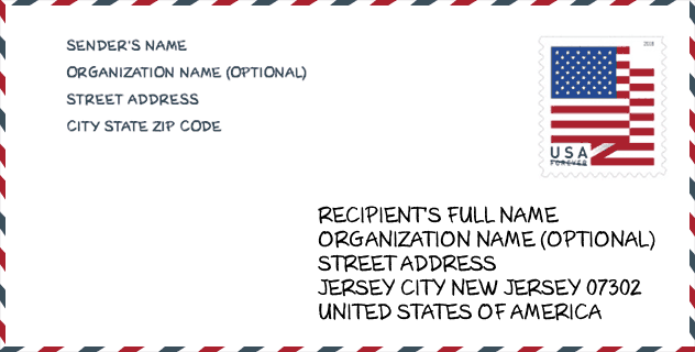
Envelope Example

This is an example of a US zip envelope. You can use a 5-digit zipcode or a detailed 9-digit zipcode to copy the mail in the following address format.
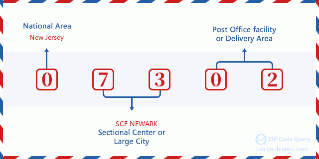
07302 Basic Meaning
What does each digit of ZIP Code 07302 stands for? The first digit designates a national area, which ranges from zero for the Northeast to nine for the far West. The 2-3 digits are the code of a sectional center facility in that region. The last two digits designate small post offices or postal zones.
Online Map

This is online map of the address Jersey City, New Jersey, United States. You may use button to move and zoom in / out. The map information is for reference only.
Hospital

This is the ZIP Code 07302 - Hospital page list. Its detail Hospital Name, Street, City, State, ZIP Code, Phone is as below.
- Name: JERSEY CITY MEDICAL CENTER
- Address: JERSEY CITY
- City: 355 GRAND STREET
- State: NJ
- ZIP Code: 07302
- Phone: (201) 915-2000
Library

This is the ZIP Code 07302 - Library page list. Its detail Library Name, Address, City, State, ZIP Code, Phone is as below.
| Name | Address | City | State | ZIP Code | Phone |
|---|---|---|---|---|---|
| JERSEY CITY BOOKMOBILE | 472 JERSEY AVENUE | JERSEY CITY | NJ | 07302 | (201) 547-4500 |
| JERSEY CITY FREE PUBLIC LIBRARY | 472 JERSEY AVENUE | JERSEY CITY | NJ | 07302 | (201) 547-4788 |
| JERSEY CITY PUBLIC LIBRARY | 472 JERSEY AVENUE | JERSEY CITY | NJ | 07302 | (201) 547-4500 |
| PAVONIA BRANCH | 326 EIGHTH AVE. | JERSEY CITY | NJ | 07302 | (201) 547-4540 |
School

This is the ZIP Code 07302 - School page list. Its detail School Name, Address, City, State, ZIP Code is as below.
| School Name | Address | City | State | Grades | ZIP Code |
|---|---|---|---|---|---|
| BelovED Community Charter School | 508 Grand Street | Jersey City | NJ | UG | 07302 |
| Explore Middle School | 180-9th St | JERSEY CITY | NJ | UG | 07302 |
| Middle School # 4 | 107 BRIGHT STREET | JERSEY CITY | NJ | UG | 07302 |
| Dr Ronald McNair High School | 123 COLES STREET | JERSEY CITY | NJ | UG | 07302 |
Population for ZIP Code 07302

What is the total population in ZIP Code 07302? Below is detail information.
- Population for ZIP Code 07302: 57,660
- 2010 Population: 36,352
The 2020 demographic statistics are in progress. The current population in ZIP code 07302 is 57,660, and the population in 2010 is 36,352.
Gender

In all the statistical population, the male population is 18,613, the female population is 17,739.
- Male Population: 18,613
- Female Population: 17,739
Race

In all the statistical population, the male population is 18,613, the female population is 17,739.
- White Population: 19,718
- Black Population: 4,702
- Hispanic Population: 6,782
- Asian Population: 10,154
- Hawaiian Population: 69
- Indian Population: 283
- Other Population: 2,949
Age

In all the statistical population, the White population is 19,718, the Black population is 4,702, the Hispanic population is 6,782, the Asian population is 10,154, the Hawaiian population is 69, the Indian Ppopulation is 283 and Other population is 2,949.
- Age's Median: 33.2
- Median of male age: 33.3
- Median of female age: 33.0
Households for ZIP Code 07302
ZIP code 07302 has 17,992 households, with an average number of 2.00 persons per household. The average income per household in Zip code 07302 is 123,617 USD, and the average house value is 668,300 USD.
- Households Per Zipcode: 17,992
- Persons Per Household: 2.00
- Average House Value: 668,300
- Income Per Household: 123,617
Geographic

The latitude of the Zip code 07302 is 40.720101, the longitude is -74.043134, and the elevation is 13. It has land area of 1.463 square miles, and water area of 0.071 square miles. The time zone for ZIP code 07302 is Eastern (GMT -05:00). Daylight saving time should be observed in the area where the zip code is located.
- Latitude: 40.720101
- Longitude: -74.043134
- Elevation: 13
- Land Area: 1.463
- Water Area: 0.071
- Time Zone: Eastern (GMT -05:00)
- Region: Northeast
- Division: Middle Atlantic
- Day Light Saving: Y
Congressional District

The Congressional District for ZIP code 07302 is New Jersey's 08th|10th congressional district, the Congressional Land Area is 54.69|75.92 square mile.
- Congressional District: 08th|10th
- Congressional Land Area: 54.69|75.92
Delivery

In the ZIP code 07302, there are 28,830 residential delivery mailboxes and centralized units, and 1,309 commercial delivery mailbox and centralized units, 3,542 single family deliveries and 24,221 multifamily deliveries, and the box count is 31,640. The main post office has city delivery carrier routes for the ZIP code 07302.
- Delivery Residential: 28,830
- Delivery Business: 1,309
- Delivery Total: 31,640
- Single Family Delivery Units: 3,542
- Multi Family Delivery Units: 24,221
- City Delivery Indicator: Y
Business

In ZIP code 07302, the number of business is 1,343, the number of employee is 27,716, the business first quarter payroll is 849,788,000 USD, the business annual payroll is 2,980,357,000 USD.
- Number Of Businesses: 1,343
- Number Of Employees: 27,716
- Business First Quarter Payroll: 849,788,000
- Business Annual Payroll: 2,980,357,000


Add new comment