ZIP Code: 07631, Englewood, NJ
ZIP Code 07631 is located in Englewood, New Jersey. Its detail State, County, City, Longitude, Latitude, Envelope Example, Population is as below.
ZIP Code 07631 Information

-
-
Country:
U.S. - United States
State:
County FIPS:
34003
County:
City:
City Type ?In many cases, a ZIP Code can have multiple "names", meaning cities, towns, or subdivisions, in its boundaries. However, it will ALWAYS have exactly 1 "default" name. D - Default - This is the "preferred" name - by the USPS - for a city. Each ZIP Code has one - and only one - "default" name. In most cases, this is what people who live in that area call the city as well. A - Acceptable - This name can be used for mailing purposes. Often times alternative names are large neighborhoods or sections of the city/town. In some cases a ZIP Code may have several "acceptable" names which is used to group towns under one ZIP Code. N - Not Acceptable - A "not acceptable" name is, in many cases, a nickname that residents give that location. According to the USPS, you should NOT send mail to that ZIP Code using the "not acceptable" name when mailing.:
D (Default)
ZIP Code:
07631
❓What does D (Default) mean? This is the "preferred" name - by the USPS - for a city. Each ZIP Code has one - and only one - "default" name. In most cases, this is what people who live in that area call the city as well.
-


-
Iconic US Landmark Legacy Designs
Get PNG, SVG, EPS, AI, PDF Versions at Just $0.1
 Download Now
-


ZipCodeCraft
ZIP Code 07631 Plus 4
ZIP Code 5 plus 4 is the extension of 5-digit zip code, It can be used to locate a more detailed location. The last four digits designate segment or one side of a street or an apartment. You can find the ZIP+4 code and corresponding address of the zip code 07631 below.
| ZIP Code 5 Plus 4 | Address |
|---|---|
| 07631-0001 | PO BOX 1, ENGLEWOOD, NJ |
| 07631-0081 | PO BOX 81, ENGLEWOOD, NJ |
| 07631-0112 | PO BOX 112, ENGLEWOOD, NJ |
| 07631-0121 | PO BOX 121, ENGLEWOOD, NJ |
| 07631-0228 | PO BOX 228, ENGLEWOOD, NJ |
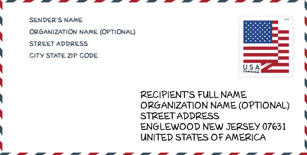
Envelope Example

This is an example of a US zip envelope. You can use a 5-digit zipcode or a detailed 9-digit zipcode to copy the mail in the following address format.
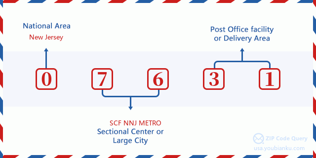
07631 Basic Meaning
What does each digit of ZIP Code 07631 stands for? The first digit designates a national area, which ranges from zero for the Northeast to nine for the far West. The 2-3 digits are the code of a sectional center facility in that region. The last two digits designate small post offices or postal zones.
Online Map

This is online map of the address Englewood, New Jersey, United States. You may use button to move and zoom in / out. The map information is for reference only.
Hospital

This is the ZIP Code 07631 - Hospital page list. Its detail Hospital Name, Street, City, State, ZIP Code, Phone is as below.
- Name: ENGLEWOOD HOSPITAL AND MEDICAL CENTER
- Address: ENGLEWOOD
- City: 350 ENGLE ST
- State: NJ
- ZIP Code: 07631
- Phone: (201) 894-3000
Museum

This is the ZIP Code 07631 - Museum page list. Its detail Museum Name, Street, City, State, ZIP Code, Phone is as below.
| Name | Street | City | State | ZIP Code | Phone |
| ENGLEWOOD HISTORICAL SOCIETY | 500 LIBERTY RD | ENGLEWOOD | NJ | 07631 | |
| FLAT ROCK BROOK NATURE CENTER | 443 VANNOSTRAND AVE | ENGLEWOOD | NJ | 07631 | (201) 567-1265 |
Library

This is the ZIP Code 07631 - Library page list. Its detail Library Name, Address, City, State, ZIP Code, Phone is as below.
| Name | Address | City | State | ZIP Code | Phone |
|---|---|---|---|---|---|
| ENGLEWOOD FREE PUBLIC LIBRARY | 31 ENGLE STREET | ENGLEWOOD | NJ | 07631 | (201) 568-2215 |
| ENGLEWOOD LIBRARY | 31 ENGLE STREET | ENGLEWOOD | NJ | 07631 | (201) 568-2215 |
School

This is the ZIP Code 07631 - School page list. Its detail School Name, Address, City, State, ZIP Code is as below.
| School Name | Address | City | State | Grades | ZIP Code |
|---|---|---|---|---|---|
| Englewood on the Palisades Charter School | 65 WEST DEMAREST AVENUE | ENGLEWOOD | NJ | UG | 07631 |
| Donald A. Quarles Early Childhood Center | 186 Davison Place | ENGLEWOOD | NJ | UG | 07631 |
| Janis E. Dismus Middle School | 325 Tryon Avenue | ENGLEWOOD | NJ | UG | 07631 |
| Dr. John Grieco Elementary School | 50 Durie Ave | Englewood | NJ | UG | 07631 |
Population for ZIP Code 07631

What is the total population in ZIP Code 07631? Below is detail information.
- Population for ZIP Code 07631: 28,796
- 2010 Population: 27,119
The 2020 demographic statistics are in progress. The current population in ZIP code 07631 is 28,796, and the population in 2010 is 27,119.
Gender

In all the statistical population, the male population is 12,846, the female population is 14,273.
- Male Population: 12,846
- Female Population: 14,273
Race

In all the statistical population, the male population is 12,846, the female population is 14,273.
- White Population: 12,908
- Black Population: 9,420
- Hispanic Population: 7,460
- Asian Population: 2,417
- Hawaiian Population: 52
- Indian Population: 351
- Other Population: 3,092
Age

In all the statistical population, the White population is 12,908, the Black population is 9,420, the Hispanic population is 7,460, the Asian population is 2,417, the Hawaiian population is 52, the Indian Ppopulation is 351 and Other population is 3,092.
- Age's Median: 38.9
- Median of male age: 36.8
- Median of female age: 40.9
Households for ZIP Code 07631
ZIP code 07631 has 10,042 households, with an average number of 2.68 persons per household. The average income per household in Zip code 07631 is 84,054 USD, and the average house value is 392,200 USD.
- Households Per Zipcode: 10,042
- Persons Per Household: 2.68
- Average House Value: 392,200
- Income Per Household: 84,054
Geographic

The latitude of the Zip code 07631 is 40.889551, the longitude is -73.972656, and the elevation is 105. It has land area of 4.908 square miles, and water area of 0.023 square miles. The time zone for ZIP code 07631 is Eastern (GMT -05:00). Daylight saving time should be observed in the area where the zip code is located.
- Latitude: 40.889551
- Longitude: -73.972656
- Elevation: 105
- Land Area: 4.908
- Water Area: 0.023
- Time Zone: Eastern (GMT -05:00)
- Region: Northeast
- Division: Middle Atlantic
- Day Light Saving: Y
Congressional District

The Congressional District for ZIP code 07631 is New Jersey's 05th|09th congressional district, the Congressional Land Area is 991.3|95.34 square mile.
- Congressional District: 05th|09th
- Congressional Land Area: 991.3|95.34
Delivery

In the ZIP code 07631, there are 10,745 residential delivery mailboxes and centralized units, and 1,333 commercial delivery mailbox and centralized units, 6,701 single family deliveries and 2,445 multifamily deliveries, and the box count is 12,674. The main post office has city delivery carrier routes for the ZIP code 07631.
- Delivery Residential: 10,745
- Delivery Business: 1,333
- Delivery Total: 12,674
- Single Family Delivery Units: 6,701
- Multi Family Delivery Units: 2,445
- City Delivery Indicator: Y
Business

In ZIP code 07631, the number of business is 1,207, the number of employee is 17,512, the business first quarter payroll is 312,348,000 USD, the business annual payroll is 1,153,671,000 USD.
- Number Of Businesses: 1,207
- Number Of Employees: 17,512
- Business First Quarter Payroll: 312,348,000
- Business Annual Payroll: 1,153,671,000


Add new comment