Amerika Syarikat Poskod: 00664
Ini senarai halaman Puerto Rico Poskod 00664. Butiran Negeri, Kaunti, Bandar, Longitud, Latitud, Contoh Sampul Surat, Populasi seperti di bawah.
, highlighting postal theme with ZIP code 00664 and cultural landmarks like Los Tres Picachos, Río Saliente, Taino petroglyphs, Cemi Museum, Monumento al Jíbaro Puertorriqueño, and Jayuya's coffee culture.")
Poskod 00664 Maklumat

-
-
Negara:
U.S. - Amerika Syarikat
Negeri:
Negeri FIPS:
72
Kod Kawasan:
Poskod:
00664
Poskod Jenis:
S (Standard)
❓Apa maksud S (Standard)? Poskod "standard" adalah apa yang difikirkan oleh kebanyakan orang ketika mereka bercakap mengenai Poskod - pada dasarnya sebuah bandar, bandar, atau pembahagian bandar yang mempunyai perkhidmatan mel.
Poskod 00664 - Bandar

Ini ialah maklumat bandar yang sepadan dengan 00664:
| Negeri | Kaunti | Bandar | Jenis Bandar ?In many cases, a ZIP Code can have multiple "names", meaning cities, towns, or subdivisions, in its boundaries. However, it will ALWAYS have exactly 1 "default" name. D - Default - This is the "preferred" name - by the USPS - for a city. Each ZIP Code has one - and only one - "default" name. In most cases, this is what people who live in that area call the city as well. A - Acceptable - This name can be used for mailing purposes. Often times alternative names are large neighborhoods or sections of the city/town. In some cases a ZIP Code may have several "acceptable" names which is used to group towns under one ZIP Code. N - Not Acceptable - A "not acceptable" name is, in many cases, a nickname that residents give that location. According to the USPS, you should NOT send mail to that ZIP Code using the "not acceptable" name when mailing. | Poskod |
|---|---|---|---|---|
| PR | Jayuya | Alts De Borinquen | N (Not Acceptable) | 00664 |
| PR | Jayuya | Alts De Jayuya | N (Not Acceptable) | 00664 |
| PR | Jayuya | Jard De Jayuya | N (Not Acceptable) | 00664 |
| PR | Jayuya | Jayuya | D (Default) | 00664 |
| PR | Jayuya | Urb Hayuya | N (Not Acceptable) | 00664 |
| PR | Jayuya | Urb La Colina | N (Not Acceptable) | 00664 |
| PR | Jayuya | Urb La Monserrate | N (Not Acceptable) | 00664 |
| PR | Jayuya | Urb Santa Clara | N (Not Acceptable) | 00664 |
| PR | Jayuya | Urb Vega Linda | N (Not Acceptable) | 00664 |
| PR | Jayuya | Valle Verde | N (Not Acceptable) | 00664 |
❓Apa maksud D (Default)? Ini adalah nama "pilihan" - oleh USPS - untuk sebuah bandar. Setiap Poskod mempunyai satu - dan hanya satu - "lalai" nama. Dalam kebanyakan kes, inilah yang dinamakan orang yang tinggal di kawasan itu juga sebagai bandar.
❓Apa maksud N (Not Acceptable)? Nama "tidak boleh diterima" adalah, dalam banyak keadaan, nama panggilan yang diberikan oleh penduduk di lokasi tersebut. Menurut USPS, anda TIDAK boleh menghantar surat ke Poskod tersebut dengan menggunakan nama "tidak boleh diterima" semasa mel.
Poskod 00664 Plus 4
Poskod 5 tambah 4 ialah lanjutan kod pos 5 digit, Ia boleh digunakan untuk mencari lokasi yang lebih terperinci. Empat digit terakhir menandakan segmen atau satu sisi jalan atau apartmen. Anda boleh mencari kod ZIP+4 dan alamat poskod 00664 yang sepadan di bawah.
| Poskod 5 Plus 4 | Alamat |
|---|---|
| 00664-0001 | PO BOX 1, JAYUYA, PR |
| 00664-0121 | PO BOX 121, JAYUYA, PR |
| 00664-0241 | PO BOX 241, JAYUYA, PR |
| 00664-0361 | PO BOX 361, JAYUYA, PR |
| 00664-0481 | PO BOX 481, JAYUYA, PR |
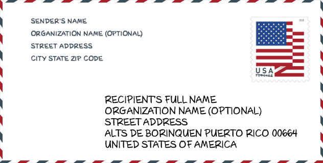
Contoh Sampul Surat

Ini adalah contoh sampul surat zip AS. Anda boleh menggunakan poskod 5 digit atau poskod 9 digit terperinci untuk menyalin surat dalam format alamat berikut.
00664 Maksud Asas
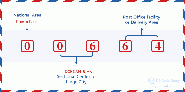
Apakah maksud setiap digit Poskod 00664? Angka pertama menunjukkan kawasan negara, yang berjulat dari sifar untuk Timur Laut hingga sembilan untuk Barat jauh. 2-3 digit adalah kod kemudahan pusat keratan di rantau itu. Dua digit terakhir menandakan pejabat pos kecil atau zon pos.
Peta Atas Talian

Ini peta atas talian untuk alamat Valle Verde, Puerto Rico, United States. Anda boleh menggunakan butang untuk bergerak dan zum masuk/keluar. Maklumat peta ini untuk rujukan sahaja.
Sekolah

Ini senarai halaman Poskod 00664 - Sekolah. Butiran Sekolah Nama, Alamat, Bandar, Negeri, Poskod seperti di bawah.
| Sekolah Nama | Alamat | Bandar | Negeri | Tingkatan | Poskod |
|---|---|---|---|---|---|
| ANGELICA TORO (NUEVA) | 48 CALLE CEMENTERIO | JAYUYA | PR | UG | 00664 |
| JOSEFINA LEON ZAYAS | CARR 144 RAMAL 141 | JAYUYA | PR | UG | 00664 |
| MIGUEL A SASTRE OLIVER | CARR 527 KM 2 HM 1 BO VEGUITA SEC GRIPINAS | JAYUYA | PR | UG | 00664 |
| SAN PATRICIO | CARR 139 KM 7 MH 6 BO SAN PATRICIO | JAYUYA | PR | UG | 00664 |
| SU ANTONIO ROMERO MUNIZ | CARR 140 KM 16 HM 0 BO COLLORES | JAYUYA | PR | UG | 00664 |
| SU ANTONIA SERRANO GONZALEZ | CARR 141 KM 11 HM 1 BO MAMEYES | JAYUYA | PR | UG | 00664 |
| SU NEMESIO R. CANALES | BO COABEY CARR 144 KM 9 HM2 | JAYUYA | PR | UG | 00664 |
| ADRIAN TORRES TORRES | CARR 141-R KM 2 HM 1 SECTOR PUEBLO | JAYUYA | PR | UG | 00664 |
Population for Poskod 00664

What is the total population in ZIP Code 00664? Below is detail information.
- Population for Poskod 00664: 9,160
- 2010 Populasi: 16,784
The 2020 demographic statistics are in progress. The current population in ZIP code 00664 is 9,160, and the population in 2010 is 16,784.
Jantina

In all the statistical population, the male population is 8,386, the female population is 8,398.
- Male Population: 8,386
- Female Population: 8,398
bangsa

In all the statistical population, the male population is 8,386, the female population is 8,398.
- White Population: 15,492
- Black Population: 755
- Hispanic Population: 16,722
- Asian Population: 20
- Hawaiian Population: 16
- Indian Population: 99
- Other Population: 743
Umur

In all the statistical population, the White population is 15,492, the Black population is 755, the Hispanic population is 16,722, the Asian population is 20, the Hawaiian population is 16, the Indian Ppopulation is 99 and Other population is 743.
- Age's Median: 33.1
- Median of male age: 31.9
- Median of female age: 34.5
Households for Poskod 00664
ZIP code 00664 has 5,615 households, with an average number of 2.98 persons per household. The average income per household in Zip code 00664 is 15,253 USD, and the average house value is 93,900 USD.
- Households Per Zipcode: 5,615
- Orang Setiap Isi Rumah: 2.98
- Nilai Rumah Purata: 93,900
- Pendapatan Setiap Isi Rumah: 15,253
Geographic

The latitude of the Zip code 00664 is 18.210309, the longitude is -66.581923, and the elevation is 1661. It has land area of 45.521 square miles, and water area of 0.001 square miles. The time zone for ZIP code 00664 is Atlantic (GMT -04:00). Daylight saving time should be observed in the area where the zip code is located.
- Latitud: 18.210309
- Longitud: -66.581923
- Kenaikan: 1661
- Kawasan tanah: 45.521
- Water Area: 0.001
- Zon Waktu: Atlantic (GMT -04:00)
- Penjimatan Cahaya Siang: N
Delivery

In the ZIP code 00664, there are 3,074 residential delivery mailboxes and centralized units, and 152 commercial delivery mailbox and centralized units, 1,960 single family deliveries and 625 multifamily deliveries, and the box count is 6,494. The main post office has city delivery carrier routes for the ZIP code 00664.
- Delivery Residential: 3,074
- Delivery Business: 152
- Delivery Total: 6,494
- Unit Penghantaran Keluarga Tunggal: 1,960
- Multi Family Delivery Units: 625
- Penunjuk Penghantaran Bandar: Y


Tambah komen baharu