Amerika Syarikat Poskod: 00677
Ini senarai halaman Puerto Rico Poskod 00677. Butiran Negeri, Kaunti, Bandar, Longitud, Latitud, Contoh Sampul Surat, Populasi seperti di bawah.

Poskod 00677 Maklumat

-
-
Negara:
U.S. - Amerika Syarikat
Negeri:
Negeri FIPS:
72
Poskod:
00677
Poskod Jenis:
S (Standard)
❓Apa maksud S (Standard)? Poskod "standard" adalah apa yang difikirkan oleh kebanyakan orang ketika mereka bercakap mengenai Poskod - pada dasarnya sebuah bandar, bandar, atau pembahagian bandar yang mempunyai perkhidmatan mel.
Poskod 00677 - Bandar

Ini ialah maklumat bandar yang sepadan dengan 00677:
| Negeri | Kaunti | Bandar | Jenis Bandar ?In many cases, a ZIP Code can have multiple "names", meaning cities, towns, or subdivisions, in its boundaries. However, it will ALWAYS have exactly 1 "default" name. D - Default - This is the "preferred" name - by the USPS - for a city. Each ZIP Code has one - and only one - "default" name. In most cases, this is what people who live in that area call the city as well. A - Acceptable - This name can be used for mailing purposes. Often times alternative names are large neighborhoods or sections of the city/town. In some cases a ZIP Code may have several "acceptable" names which is used to group towns under one ZIP Code. N - Not Acceptable - A "not acceptable" name is, in many cases, a nickname that residents give that location. According to the USPS, you should NOT send mail to that ZIP Code using the "not acceptable" name when mailing. | Poskod |
|---|---|---|---|---|
| PR | Rincon | Comunidad Estella | N (Not Acceptable) | 00677 |
| PR | Rincon | Comunidad Stella | N (Not Acceptable) | 00677 |
| PR | Rincon | Ext Jard De Rincon | N (Not Acceptable) | 00677 |
| PR | Rincon | Jard De Rincon | N (Not Acceptable) | 00677 |
| PR | Rincon | Punta Del Mar Beach Vlg | N (Not Acceptable) | 00677 |
| PR | Rincon | Rincon | D (Default) | 00677 |
| PR | Rincon | Urb Cerro Los Pobres | N (Not Acceptable) | 00677 |
| PR | Rincon | Urb Las Lomas | N (Not Acceptable) | 00677 |
| PR | Rincon | Urb Palma Real | N (Not Acceptable) | 00677 |
| PR | Rincon | Urb Sea Beach Colony | N (Not Acceptable) | 00677 |
| PR | Rincon | Villas De La Pradera | N (Not Acceptable) | 00677 |
| PR | Rincon | Vista Azul | N (Not Acceptable) | 00677 |
❓Apa maksud D (Default)? Ini adalah nama "pilihan" - oleh USPS - untuk sebuah bandar. Setiap Poskod mempunyai satu - dan hanya satu - "lalai" nama. Dalam kebanyakan kes, inilah yang dinamakan orang yang tinggal di kawasan itu juga sebagai bandar.
❓Apa maksud N (Not Acceptable)? Nama "tidak boleh diterima" adalah, dalam banyak keadaan, nama panggilan yang diberikan oleh penduduk di lokasi tersebut. Menurut USPS, anda TIDAK boleh menghantar surat ke Poskod tersebut dengan menggunakan nama "tidak boleh diterima" semasa mel.
Poskod 00677 Plus 4
Poskod 5 tambah 4 ialah lanjutan kod pos 5 digit, Ia boleh digunakan untuk mencari lokasi yang lebih terperinci. Empat digit terakhir menandakan segmen atau satu sisi jalan atau apartmen. Anda boleh mencari kod ZIP+4 dan alamat poskod 00677 yang sepadan di bawah.
| Poskod 5 Plus 4 | Alamat |
|---|---|
| 00677-0001 | PO BOX 1, RINCON, PR |
| 00677-0121 | PO BOX 121, RINCON, PR |
| 00677-0241 | PO BOX 241, RINCON, PR |
| 00677-0361 | PO BOX 361, RINCON, PR |
| 00677-0417 | PO BOX 419, RINCON, PR |
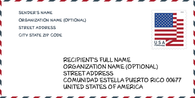
Contoh Sampul Surat

Ini adalah contoh sampul surat zip AS. Anda boleh menggunakan poskod 5 digit atau poskod 9 digit terperinci untuk menyalin surat dalam format alamat berikut.
00677 Maksud Asas
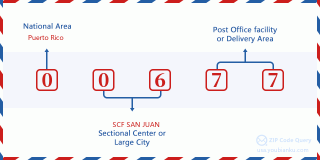
Apakah maksud setiap digit Poskod 00677? Angka pertama menunjukkan kawasan negara, yang berjulat dari sifar untuk Timur Laut hingga sembilan untuk Barat jauh. 2-3 digit adalah kod kemudahan pusat keratan di rantau itu. Dua digit terakhir menandakan pejabat pos kecil atau zon pos.
Peta Atas Talian

Ini peta atas talian untuk alamat Vista Azul, Puerto Rico, United States. Anda boleh menggunakan butang untuk bergerak dan zum masuk/keluar. Maklumat peta ini untuk rujukan sahaja.
Sekolah

Ini senarai halaman Poskod 00677 - Sekolah. Butiran Sekolah Nama, Alamat, Bandar, Negeri, Poskod seperti di bawah.
| Sekolah Nama | Alamat | Bandar | Negeri | Tingkatan | Poskod |
|---|---|---|---|---|---|
| MANUEL GARCIA PEREZ (NUEVA) | CALLE PEDRO ALBIZU CAMPOS INTERIOR | RINCON | PR | UG | 00677 |
| CONRADO RODRIGUEZ | CALLE LUIS MUNOZ RIVERA FINAL | RINCON | PR | UG | 00677 |
| MANUEL GONZALEZ MELO | CARR 115 KM 9 HM 0 BO CANVALACHE | RINCON | PR | UG | 00677 |
Population for Poskod 00677

What is the total population in ZIP Code 00677? Below is detail information.
- Population for Poskod 00677: 10,301
- 2010 Populasi: 15,272
The 2020 demographic statistics are in progress. The current population in ZIP code 00677 is 10,301, and the population in 2010 is 15,272.
Jantina

In all the statistical population, the male population is 7,414, the female population is 7,858.
- Male Population: 7,414
- Female Population: 7,858
bangsa

In all the statistical population, the male population is 7,414, the female population is 7,858.
- White Population: 13,464
- Black Population: 1,075
- Hispanic Population: 14,732
- Asian Population: 38
- Hawaiian Population: 11
- Indian Population: 153
- Other Population: 993
Umur

In all the statistical population, the White population is 13,464, the Black population is 1,075, the Hispanic population is 14,732, the Asian population is 38, the Hawaiian population is 11, the Indian Ppopulation is 153 and Other population is 993.
- Age's Median: 40.5
- Median of male age: 39.4
- Median of female age: 41.5
Households for Poskod 00677
ZIP code 00677 has 6,028 households, with an average number of 2.52 persons per household. The average income per household in Zip code 00677 is 21,673 USD, and the average house value is 121,100 USD.
- Households Per Zipcode: 6,028
- Orang Setiap Isi Rumah: 2.52
- Nilai Rumah Purata: 121,100
- Pendapatan Setiap Isi Rumah: 21,673
Geographic

The latitude of the Zip code 00677 is 18.331739, the longitude is -67.231158, and the elevation is 297. It has land area of 14.339 square miles, and water area of 1.388 square miles. The time zone for ZIP code 00677 is Atlantic (GMT -04:00). Daylight saving time should be observed in the area where the zip code is located.
- Latitud: 18.331739
- Longitud: -67.231158
- Kenaikan: 297
- Kawasan tanah: 14.339
- Water Area: 1.388
- Zon Waktu: Atlantic (GMT -04:00)
- Penjimatan Cahaya Siang: N
Delivery

In the ZIP code 00677, there are 4,088 residential delivery mailboxes and centralized units, and 142 commercial delivery mailbox and centralized units, 2,408 single family deliveries and 1,070 multifamily deliveries, and the box count is 7,953. The main post office has city delivery carrier routes for the ZIP code 00677.
- Delivery Residential: 4,088
- Delivery Business: 142
- Delivery Total: 7,953
- Unit Penghantaran Keluarga Tunggal: 2,408
- Multi Family Delivery Units: 1,070
- Penunjuk Penghantaran Bandar: Y


Tambah komen baharu