Amerika Syarikat Poskod: 04017
Ini senarai halaman Maine Poskod 04017. Butiran Negeri, Kaunti, Bandar, Longitud, Latitud, Contoh Sampul Surat, Populasi seperti di bawah.

Poskod 04017 Maklumat

-
-
Negara:
U.S. - Amerika Syarikat
Negeri:
Negeri FIPS:
23
Kod Kawasan:
Poskod:
04017
Poskod Jenis:
S (Standard)
❓Apa maksud S (Standard)? Poskod "standard" adalah apa yang difikirkan oleh kebanyakan orang ketika mereka bercakap mengenai Poskod - pada dasarnya sebuah bandar, bandar, atau pembahagian bandar yang mempunyai perkhidmatan mel.
Poskod 04017 - Bandar

Ini ialah maklumat bandar yang sepadan dengan 04017:
| Negeri | Kaunti | Bandar | Jenis Bandar ?In many cases, a ZIP Code can have multiple "names", meaning cities, towns, or subdivisions, in its boundaries. However, it will ALWAYS have exactly 1 "default" name. D - Default - This is the "preferred" name - by the USPS - for a city. Each ZIP Code has one - and only one - "default" name. In most cases, this is what people who live in that area call the city as well. A - Acceptable - This name can be used for mailing purposes. Often times alternative names are large neighborhoods or sections of the city/town. In some cases a ZIP Code may have several "acceptable" names which is used to group towns under one ZIP Code. N - Not Acceptable - A "not acceptable" name is, in many cases, a nickname that residents give that location. According to the USPS, you should NOT send mail to that ZIP Code using the "not acceptable" name when mailing. | Poskod |
|---|---|---|---|---|
| ME | Cumberland | Chebeague Is | A (Acceptable) | 04017 |
| ME | Cumberland | Chebeague Island | D (Default) | 04017 |
❓Apa maksud D (Default)? Ini adalah nama "pilihan" - oleh USPS - untuk sebuah bandar. Setiap Poskod mempunyai satu - dan hanya satu - "lalai" nama. Dalam kebanyakan kes, inilah yang dinamakan orang yang tinggal di kawasan itu juga sebagai bandar.
❓Apa maksud A (Acceptable)? Nama ini boleh digunakan untuk tujuan mel. Seringkali nama alternatif adalah kawasan kejiranan atau bahagian bandar / bandar yang besar. Dalam beberapa kes, Poskod mungkin mempunyai beberapa nama "boleh diterima" yang digunakan untuk mengelompokkan bandar di bawah satu Poskod.
Poskod 04017 Plus 4
Poskod 5 tambah 4 ialah lanjutan kod pos 5 digit, Ia boleh digunakan untuk mencari lokasi yang lebih terperinci. Empat digit terakhir menandakan segmen atau satu sisi jalan atau apartmen. Anda boleh mencari kod ZIP+4 dan alamat poskod 04017 yang sepadan di bawah.
| Poskod 5 Plus 4 | Alamat |
|---|---|
| 04017-0001 | PO BOX 1, CHEBEAGUE ISLAND, ME |
| 04017-0009 | 1001 BUTHESTA RD, CHEBEAGUE ISLAND, ME |
| 04017-0010 | PO BOX 10, CHEBEAGUE ISLAND, ME |
| 04017-0100 | PO BOX 9, CHEBEAGUE ISLAND, ME |
| 04017-3000 | 1 SOUTH RD, CHEBEAGUE ISLAND, ME |
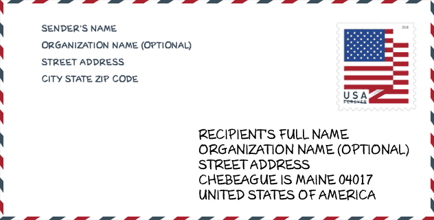
Contoh Sampul Surat

Ini adalah contoh sampul surat zip AS. Anda boleh menggunakan poskod 5 digit atau poskod 9 digit terperinci untuk menyalin surat dalam format alamat berikut.
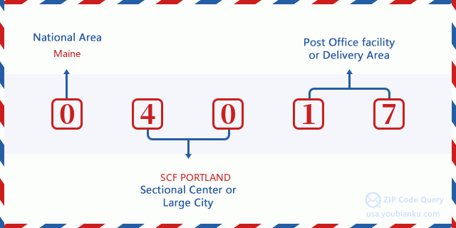
04017 Maksud Asas
Apakah maksud setiap digit Poskod 04017? Angka pertama menunjukkan kawasan negara, yang berjulat dari sifar untuk Timur Laut hingga sembilan untuk Barat jauh. 2-3 digit adalah kod kemudahan pusat keratan di rantau itu. Dua digit terakhir menandakan pejabat pos kecil atau zon pos.
Peta Atas Talian

Ini peta atas talian untuk alamat Chebeague Island, Maine, United States. Anda boleh menggunakan butang untuk bergerak dan zum masuk/keluar. Maklumat peta ini untuk rujukan sahaja.
Muzium

Ini senarai halaman Poskod 04017 - Muzium. Butiran Muzium Nama, Jalan, Bandar, Negeri, Poskod, Telefon seperti di bawah.
- Nama: MUSEUM OF CHEBEAGUE HISTORY
- Jalan: 137 SOUTH RD
- Bandar: CHEBEAGUE ISLAND
- Negeri: ME
- Poskod: 04017
- Telefon: (207) 846-5237
Perpustakaan

Ini senarai halaman Poskod 04017 - Perpustakaan. Butiran Perpustakaan Nama, Alamat, Bandar, Negeri, Poskod, Telefon seperti di bawah.
- Nama: CHEBEAGUE ISLAND LIBRARY
- Alamat: 247 SOUTH ROAD, UNIT 3
- Bandar: CHEBEAGUE ISLAND
- Negeri: ME - Maine
- Poskod: 04017
- Telefon: (207) 846-4351
Sekolah

Ini senarai halaman Poskod 04017 - Sekolah. Butiran Sekolah Nama, Alamat, Bandar, Negeri, Poskod seperti di bawah.
- Sekolah Nama: Chebeague Island School
- Alamat: 14 School House Road
- Bandar: Chebeague Island
- Negeri: ME
- Tingkatan: UG
- Poskod: 04017
Population for Poskod 04017

What is the total population in ZIP Code 04017? Below is detail information.
- Population for Poskod 04017: 634
- 2010 Populasi: 341
The 2020 demographic statistics are in progress. The current population in ZIP code 04017 is 634, and the population in 2010 is 341.
Jantina

In all the statistical population, the male population is 165, the female population is 176.
- Male Population: 165
- Female Population: 176
bangsa

In all the statistical population, the male population is 165, the female population is 176.
- White Population: 339
- Black Population: 1
- Hispanic Population: 0
- Asian Population: 2
- Hawaiian Population: 0
- Indian Population: 0
- Other Population: 0
Umur

In all the statistical population, the White population is 339, the Black population is 1, the Hispanic population is 0, the Asian population is 2, the Hawaiian population is 0, the Indian Ppopulation is 0 and Other population is 0.
- Age's Median: 57.9
- Median of male age: 53.6
- Median of female age: 60.8
Households for Poskod 04017
ZIP code 04017 has 171 households, with an average number of 1.99 persons per household. The average income per household in Zip code 04017 is 63,542 USD, and the average house value is 433,300 USD.
- Households Per Zipcode: 171
- Orang Setiap Isi Rumah: 1.99
- Nilai Rumah Purata: 433,300
- Pendapatan Setiap Isi Rumah: 63,542
Geographic

The latitude of the Zip code 04017 is 43.733748, the longitude is -70.118125, and the elevation is 158. It has land area of 3.574 square miles, and water area of 16.042 square miles. The time zone for ZIP code 04017 is Eastern (GMT -05:00). Daylight saving time should be observed in the area where the zip code is located.
- Latitud: 43.733748
- Longitud: -70.118125
- Kenaikan: 158
- Kawasan tanah: 3.574
- Water Area: 16.042
- Zon Waktu: Eastern (GMT -05:00)
- Rantau: Northeast
- Bahagian: New England
- Penjimatan Cahaya Siang: Y
Daerah Kongres

The Congressional District for ZIP code 04017 is Maine's 1st congressional district, the Congressional Land Area is 3285.52 square mile.
- Daerah Kongres: 1st
- Kawasan Tanah Kongres: 3285.52
Delivery

In the ZIP code 04017, there are 319 residential delivery mailboxes and centralized units, and 10 commercial delivery mailbox and centralized units, 319 single family deliveries and 0 multifamily deliveries, and the box count is 364. The main post office does not have city delivery carrier routes for the ZIP code 04017.
- Delivery Residential: 319
- Delivery Business: 10
- Delivery Total: 364
- Unit Penghantaran Keluarga Tunggal: 319
- Multi Family Delivery Units: 0
- Penunjuk Penghantaran Bandar: N
Perniagaan

In ZIP code 04017, the number of business is 25, the number of employee is 61, the business first quarter payroll is 372,000 USD, the business annual payroll is 2,688,000 USD.
- Number Of Businesses: 25
- Number Of Employees: 61
- Gaji Suku Pertama Perniagaan: 372,000
- Gaji Tahunan Perniagaan: 2,688,000


Tambah komen baharu