Amerika Syarikat Poskod: 48070
Ini senarai halaman Michigan Poskod 48070. Butiran Negeri, Kaunti, Bandar, Longitud, Latitud, Contoh Sampul Surat, Populasi seperti di bawah.

Poskod 48070 Maklumat

-
-
Negara:
U.S. - Amerika Syarikat
Negeri:
Negeri FIPS:
26
Poskod:
48070
Poskod Jenis:
S (Standard)
❓Apa maksud S (Standard)? Poskod "standard" adalah apa yang difikirkan oleh kebanyakan orang ketika mereka bercakap mengenai Poskod - pada dasarnya sebuah bandar, bandar, atau pembahagian bandar yang mempunyai perkhidmatan mel.
Poskod 48070 - Bandar

Ini ialah maklumat bandar yang sepadan dengan 48070:
| Negeri | Kaunti | Bandar | Jenis Bandar ?In many cases, a ZIP Code can have multiple "names", meaning cities, towns, or subdivisions, in its boundaries. However, it will ALWAYS have exactly 1 "default" name. D - Default - This is the "preferred" name - by the USPS - for a city. Each ZIP Code has one - and only one - "default" name. In most cases, this is what people who live in that area call the city as well. A - Acceptable - This name can be used for mailing purposes. Often times alternative names are large neighborhoods or sections of the city/town. In some cases a ZIP Code may have several "acceptable" names which is used to group towns under one ZIP Code. N - Not Acceptable - A "not acceptable" name is, in many cases, a nickname that residents give that location. According to the USPS, you should NOT send mail to that ZIP Code using the "not acceptable" name when mailing. | Poskod |
|---|---|---|---|---|
| MI | Oakland | Huntingtn Wds | A (Acceptable) | 48070 |
| MI | Oakland | Huntington Wd | N (Not Acceptable) | 48070 |
| MI | Oakland | Huntington Woods | D (Default) | 48070 |
❓Apa maksud D (Default)? Ini adalah nama "pilihan" - oleh USPS - untuk sebuah bandar. Setiap Poskod mempunyai satu - dan hanya satu - "lalai" nama. Dalam kebanyakan kes, inilah yang dinamakan orang yang tinggal di kawasan itu juga sebagai bandar.
❓Apa maksud A (Acceptable)? Nama ini boleh digunakan untuk tujuan mel. Seringkali nama alternatif adalah kawasan kejiranan atau bahagian bandar / bandar yang besar. Dalam beberapa kes, Poskod mungkin mempunyai beberapa nama "boleh diterima" yang digunakan untuk mengelompokkan bandar di bawah satu Poskod.
❓Apa maksud N (Not Acceptable)? Nama "tidak boleh diterima" adalah, dalam banyak keadaan, nama panggilan yang diberikan oleh penduduk di lokasi tersebut. Menurut USPS, anda TIDAK boleh menghantar surat ke Poskod tersebut dengan menggunakan nama "tidak boleh diterima" semasa mel.
Poskod 48070 Plus 4
Poskod 5 tambah 4 ialah lanjutan kod pos 5 digit, Ia boleh digunakan untuk mencari lokasi yang lebih terperinci. Empat digit terakhir menandakan segmen atau satu sisi jalan atau apartmen. Anda boleh mencari kod ZIP+4 dan alamat poskod 48070 yang sepadan di bawah.
| Poskod 5 Plus 4 | Alamat |
|---|---|
| 48070-0899 | 40401 VICHINDO AVE, HUNTINGTON WOODS, MI |
| 48070-1000 | 12700 LASALLE LN, HUNTINGTON WOODS, MI |
| 48070-1001 | 12701 BORGMAN AVE, HUNTINGTON WOODS, MI |
| 48070-1002 | 12700 BORGMAN AVE, HUNTINGTON WOODS, MI |
| 48070-1003 | 13101 BORGMAN AVE, HUNTINGTON WOODS, MI |
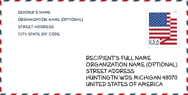
Contoh Sampul Surat

Ini adalah contoh sampul surat zip AS. Anda boleh menggunakan poskod 5 digit atau poskod 9 digit terperinci untuk menyalin surat dalam format alamat berikut.
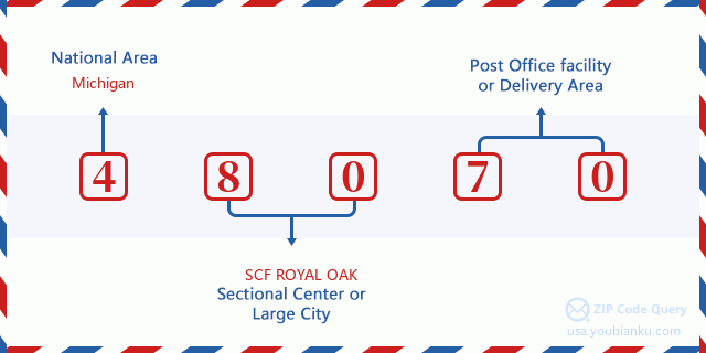
48070 Maksud Asas
Apakah maksud setiap digit Poskod 48070? Angka pertama menunjukkan kawasan negara, yang berjulat dari sifar untuk Timur Laut hingga sembilan untuk Barat jauh. 2-3 digit adalah kod kemudahan pusat keratan di rantau itu. Dua digit terakhir menandakan pejabat pos kecil atau zon pos.
Peta Atas Talian

Ini peta atas talian untuk alamat Huntington Woods, Michigan, United States. Anda boleh menggunakan butang untuk bergerak dan zum masuk/keluar. Maklumat peta ini untuk rujukan sahaja.
Perpustakaan

Ini senarai halaman Poskod 48070 - Perpustakaan. Butiran Perpustakaan Nama, Alamat, Bandar, Negeri, Poskod, Telefon seperti di bawah.
- Nama: HUNTINGTON WOODS PUBLIC LIBRARY
- Alamat: 26415 SCOTIA ROAD
- Bandar: HUNTINGTON WOODS
- Negeri: MI - Michigan
- Poskod: 48070
- Telefon: (248) 543-9720
Population for Poskod 48070

What is the total population in ZIP Code 48070? Below is detail information.
- Population for Poskod 48070: 6,407
- 2010 Populasi: 6,238
The 2020 demographic statistics are in progress. The current population in ZIP code 48070 is 6,407, and the population in 2010 is 6,238.
Jantina

In all the statistical population, the male population is 3,067, the female population is 3,171.
- Male Population: 3,067
- Female Population: 3,171
bangsa

In all the statistical population, the male population is 3,067, the female population is 3,171.
- White Population: 6,054
- Black Population: 88
- Hispanic Population: 99
- Asian Population: 110
- Hawaiian Population: 0
- Indian Population: 33
- Other Population: 36
Umur

In all the statistical population, the White population is 6,054, the Black population is 88, the Hispanic population is 99, the Asian population is 110, the Hawaiian population is 0, the Indian Ppopulation is 33 and Other population is 36.
- Age's Median: 42.0
- Median of male age: 41.2
- Median of female age: 43.0
Households for Poskod 48070
ZIP code 48070 has 2,354 households, with an average number of 2.65 persons per household. The average income per household in Zip code 48070 is 130,417 USD, and the average house value is 349,500 USD.
- Households Per Zipcode: 2,354
- Orang Setiap Isi Rumah: 2.65
- Nilai Rumah Purata: 349,500
- Pendapatan Setiap Isi Rumah: 130,417
Geographic

The latitude of the Zip code 48070 is 42.481896, the longitude is -83.165645, and the elevation is 657. It has land area of 1.488 square miles, and water area of 0 square miles. The time zone for ZIP code 48070 is Eastern (GMT -05:00). Daylight saving time should be observed in the area where the zip code is located.
- Latitud: 42.481896
- Longitud: -83.165645
- Kenaikan: 657
- Kawasan tanah: 1.488
- Water Area: 0
- Zon Waktu: Eastern (GMT -05:00)
- Rantau: Midwest
- Bahagian: East North Central
- Penjimatan Cahaya Siang: Y
Daerah Kongres

The Congressional District for ZIP code 48070 is Michigan's 09th congressional district, the Congressional Land Area is 183.59 square mile.
- Daerah Kongres: 09th
- Kawasan Tanah Kongres: 183.59
Delivery

In the ZIP code 48070, there are 2,418 residential delivery mailboxes and centralized units, and 74 commercial delivery mailbox and centralized units, 2,418 single family deliveries and 0 multifamily deliveries, and the box count is 2,538. The main post office has city delivery carrier routes for the ZIP code 48070.
- Delivery Residential: 2,418
- Delivery Business: 74
- Delivery Total: 2,538
- Unit Penghantaran Keluarga Tunggal: 2,418
- Multi Family Delivery Units: 0
- Penunjuk Penghantaran Bandar: Y
Perniagaan

In ZIP code 48070, the number of business is 113, the number of employee is 437, the business first quarter payroll is 5,197,000 USD, the business annual payroll is 23,929,000 USD.
- Number Of Businesses: 113
- Number Of Employees: 437
- Gaji Suku Pertama Perniagaan: 5,197,000
- Gaji Tahunan Perniagaan: 23,929,000
Faedah Jaminan Sosial

Terdapat 1,195 penerima dengan faedah dalam status pembayaran semasa untuk poskod 48070, yang mana 1,005 adalah pekerja yang sudah bersara, 35 adalah pekerja yang kurang upaya, 45 adalah janda dan ibu bapa, 70 adalah pasangan dan 40 adalah anak-anak. Bilangan penerima yang berumur 65 tahun atau lebih adalah 1,100. Jumlah faedah bulanan adalah 2,308,000 USD, di mana 2,054,000 USD untuk pekerja yang sudah bersara, 85,000 USD untuk janda dan ibu bapa.
- Jumlah nombor: 1,195
- Bilangan pekerja yang telah bersara: 1,005
- Bilangan pekerja kurang upaya: 35
- Bilangan balu dan ibu bapa: 45
- Nombor Pasangan: 70
- Nombor Kanak-kanak: 40
- Semua benefisiari setiap bulan: 2,308,000
- Pekerja yang telah bersara sebulan: 2,054,000
- Janda dan ibu bapa setiap bulan: 85,000
- Bilangan penerima yang berumur 65 tahun ke atas: 1,100


Tambah komen baharu