Verenigde Staten Postcode: 00669
Dit is de paginalijst van Puerto Rico Postcode 00669. Hieronder is het detail van Staat, Graafschap, Stad, Lengte, Breedtegraad, Envelop Voorbeeld, Bevolking.

Postcode 00669 Informatie

-
-
Land:
U.S. - Verenigde Staten
Staat:
Staat FIPS:
72
Netnummer:
Postcode:
00669
Postcode Type:
S (Standard)
❓Wat betekent S (Standard)? Een "standaard" postcode is waar de meeste mensen aan denken als ze het over postcodes hebben - in wezen een stad, een stad of een afdeling van een stad die een postdienst heeft.
Postcode 00669 - Stad

Dit is de stadsinformatie die overeenkomt met 00669:
| Staat | Graafschap | Stad | Stadtype ?In many cases, a ZIP Code can have multiple "names", meaning cities, towns, or subdivisions, in its boundaries. However, it will ALWAYS have exactly 1 "default" name. D - Default - This is the "preferred" name - by the USPS - for a city. Each ZIP Code has one - and only one - "default" name. In most cases, this is what people who live in that area call the city as well. A - Acceptable - This name can be used for mailing purposes. Often times alternative names are large neighborhoods or sections of the city/town. In some cases a ZIP Code may have several "acceptable" names which is used to group towns under one ZIP Code. N - Not Acceptable - A "not acceptable" name is, in many cases, a nickname that residents give that location. According to the USPS, you should NOT send mail to that ZIP Code using the "not acceptable" name when mailing. | Postcode |
|---|---|---|---|---|
| PR | Lares | Haciendas De Borinquen Ii | N (Not Acceptable) | 00669 |
| PR | Lares | Lares | D (Default) | 00669 |
| PR | Lares | Urb Buena Vista | N (Not Acceptable) | 00669 |
❓Wat betekent D (Default)? Dit is de "geprefereerde" naam - door de USPS - voor een stad. Elke postcode heeft één - en slechts één - "standaard" naam. In de meeste gevallen noemen mensen die in dat gebied wonen de stad ook.
❓Wat betekent N (Not Acceptable)? Een "niet acceptabele" naam is in veel gevallen een bijnaam die bewoners aan die locatie geven. Volgens de USPS mag je GEEN post naar die postcode sturen met de "niet acceptabele" naam bij het mailen.
Postcode 00669 Plus 4
ZIP Code 5 plus 4 is de uitbreiding van de 5-cijferige postcode, het kan worden gebruikt om een meer gedetailleerde locatie te vinden. De laatste vier cijfers duiden een segment of een kant van een straat of een appartement aan. Hieronder vindt u de postcode en het bijbehorende adres van de postcode 00669.
| Postcode 5 Plus 4 | Adres |
|---|---|
| 00669-0001 | PO BOX 1, LARES, PR |
| 00669-0121 | PO BOX 121, LARES, PR |
| 00669-0201 | PO BOX 202, LARES, PR |
| 00669-0203 | PO BOX 203, LARES, PR |
| 00669-0241 | PO BOX 241, LARES, PR |
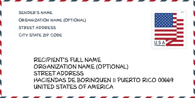
Envelop Voorbeeld

Dit is een voorbeeld van een Amerikaanse postenvelop. U kunt een 5-cijferige postcode of een gedetailleerde 9-cijferige postcode gebruiken om de mail in het volgende adresformaat te kopiëren.
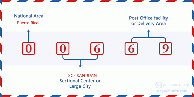
00669 Basisbetekenis
Waar staat elk cijfer van postcode 00669 voor? Het eerste cijfer geeft een nationaal gebied aan, dat varieert van nul voor het noordoosten tot negen voor het verre westen. De 2-3 cijfers zijn de code van een sectiecentrumfaciliteit in die regio. De laatste twee cijfers duiden kleine postkantoren of postzones aan.
Online landkaart

Het is een online kaart van adres Urb Buena Vista, Puerto Rico, United States. U kunt Knopje gebruiken te in/uitzoomen. De kaartinformatie is alleen ter referentie.
School

Dit is de paginalijst van Postcode 00669 - School. Hieronder is het detail van School Naam, Adres, Stad, Staat, Postcode.
| School Naam | Adres | Stad | Staat | Klassen | Postcode |
|---|---|---|---|---|---|
| ELEMENTAL DANIEL VELEZ SOTO | CARR 111 KM 2 HM 0 | LARES | PR | UG | 00669 |
| DOMINGO APONTE COLLAZO | CARR 111 CALLE RAMON DE JESUS SIERRA | LARES | PR | UG | 00669 |
| GEORGE WASHINGTON | CARR 111 KM 33 HM 9 BO PUEBLO SECT BURUQUILLO | LARES | PR | UG | 00669 |
| JULIO LEBRON SOTO | CARR 135 KM 60 BO CASTANER | LARES | PR | UG | 00669 |
| PROFESOR RAFAEL ALICEA VAZQUEZ (JOSEFINA LINARES) | CARR 111 KM 12.5 BO. LARES | LARES | PR | UG | 00669 |
| SU ANGELICA DELGADO (SU AMERICA) | CARR 129 KM 135 BARRIO BUENOS AIRES SEC LA AMERICA | LARES | PR | UG | 00669 |
| GABRIELA MISTRAL | CARR 135 KM 65.6 | LARES | PR | UG | 00669 |
| HECTOR HERNANDEZ ARANA (INTERMEDIA BO PILETAS) | CARR 129 KM 24.7 | LARES | PR | UG | 00669 |
| RAMON DE JESUS SIERRA | AVE LOS PATRIOTAS | LARES | PR | UG | 00669 |
Population for Postcode 00669

What is the total population in ZIP Code 00669? Below is detail information.
- Population for Postcode 00669: 15,397
- 2010 Bevolking: 29,744
The 2020 demographic statistics are in progress. The current population in ZIP code 00669 is 15,397, and the population in 2010 is 29,744.
Geslacht

In all the statistical population, the male population is 14,621, the female population is 15,123.
- Male Population: 14,621
- Female Population: 15,123
Race

In all the statistical population, the male population is 14,621, the female population is 15,123.
- White Population: 27,619
- Black Population: 1,297
- Hispanic Population: 29,536
- Asian Population: 33
- Hawaiian Population: 22
- Indian Population: 156
- Other Population: 1,305
Leeftijd

In all the statistical population, the White population is 27,619, the Black population is 1,297, the Hispanic population is 29,536, the Asian population is 33, the Hawaiian population is 22, the Indian Ppopulation is 156 and Other population is 1,305.
- Age's Median: 37.0
- Median of male age: 35.8
- Median of female age: 38.3
Households for Postcode 00669
ZIP code 00669 has 10,740 households, with an average number of 2.75 persons per household. The average income per household in Zip code 00669 is 14,816 USD, and the average house value is 88,000 USD.
- Households Per Zipcode: 10,740
- Personen per huishouden: 2.75
- Gemiddelde huiswaarde: 88,000
- Inkomen per huishouden: 14,816
Geographic

The latitude of the Zip code 00669 is 18.291418, the longitude is -66.867756, and the elevation is 1029. It has land area of 61.552 square miles, and water area of 0.065 square miles. The time zone for ZIP code 00669 is Atlantic (GMT -04:00). Daylight saving time should be observed in the area where the zip code is located.
- Breedtegraad: 18.291418
- Lengte: -66.867756
- Elevatie: 1029
- Landoppervlak: 61.552
- Water Area: 0.065
- Tijd Zone: Atlantic (GMT -04:00)
- Zomertijd: N
Levering

In the ZIP code 00669, there are 5,599 residential delivery mailboxes and centralized units, and 190 commercial delivery mailbox and centralized units, 3,566 single family deliveries and 272 multifamily deliveries, and the box count is 7,421. The main post office has city delivery carrier routes for the ZIP code 00669.
- Delivery Residential: 5,599
- Delivery Business: 190
- Delivery Total: 7,421
- Leveringseenheden voor één gezin: 3,566
- Multi Family Delivery Units: 272
- Stadsleveringsindicator: Y


Reactie toevoegen