Verenigde Staten Postcode: 00676
Dit is de paginalijst van Puerto Rico Postcode 00676. Hieronder is het detail van Staat, Graafschap, Stad, Lengte, Breedtegraad, Envelop Voorbeeld, Bevolking.

Postcode 00676 Informatie

-
-
Land:
U.S. - Verenigde Staten
Staat:
Staat FIPS:
72
Postcode:
00676
Postcode Type:
S (Standard)
❓Wat betekent S (Standard)? Een "standaard" postcode is waar de meeste mensen aan denken als ze het over postcodes hebben - in wezen een stad, een stad of een afdeling van een stad die een postdienst heeft.
Postcode 00676 - Stad

Dit is de stadsinformatie die overeenkomt met 00676:
| Staat | Graafschap | Stad | Stadtype ?In many cases, a ZIP Code can have multiple "names", meaning cities, towns, or subdivisions, in its boundaries. However, it will ALWAYS have exactly 1 "default" name. D - Default - This is the "preferred" name - by the USPS - for a city. Each ZIP Code has one - and only one - "default" name. In most cases, this is what people who live in that area call the city as well. A - Acceptable - This name can be used for mailing purposes. Often times alternative names are large neighborhoods or sections of the city/town. In some cases a ZIP Code may have several "acceptable" names which is used to group towns under one ZIP Code. N - Not Acceptable - A "not acceptable" name is, in many cases, a nickname that residents give that location. According to the USPS, you should NOT send mail to that ZIP Code using the "not acceptable" name when mailing. | Postcode |
|---|---|---|---|---|
| PR | Moca | Hacienda La Monserrate | N (Not Acceptable) | 00676 |
| PR | Moca | Moca | D (Default) | 00676 |
| PR | Moca | Parc Lomas Verdes | N (Not Acceptable) | 00676 |
| PR | Moca | Parc Sabana | N (Not Acceptable) | 00676 |
| PR | Moca | Res Edad Dorada | N (Not Acceptable) | 00676 |
| PR | Moca | Urb Las Palmas | N (Not Acceptable) | 00676 |
| PR | Moca | Urb Los Robles | N (Not Acceptable) | 00676 |
| PR | Moca | Urb Moca Gdns | N (Not Acceptable) | 00676 |
| PR | Moca | Urb Monte Verde Hills | N (Not Acceptable) | 00676 |
| PR | Moca | Villa Deloamit | N (Not Acceptable) | 00676 |
| PR | Moca | Villa Mercedes | N (Not Acceptable) | 00676 |
| PR | Moca | Villa Soto | N (Not Acceptable) | 00676 |
❓Wat betekent D (Default)? Dit is de "geprefereerde" naam - door de USPS - voor een stad. Elke postcode heeft één - en slechts één - "standaard" naam. In de meeste gevallen noemen mensen die in dat gebied wonen de stad ook.
❓Wat betekent N (Not Acceptable)? Een "niet acceptabele" naam is in veel gevallen een bijnaam die bewoners aan die locatie geven. Volgens de USPS mag je GEEN post naar die postcode sturen met de "niet acceptabele" naam bij het mailen.
Postcode 00676 Plus 4
ZIP Code 5 plus 4 is de uitbreiding van de 5-cijferige postcode, het kan worden gebruikt om een meer gedetailleerde locatie te vinden. De laatste vier cijfers duiden een segment of een kant van een straat of een appartement aan. Hieronder vindt u de postcode en het bijbehorende adres van de postcode 00676.
| Postcode 5 Plus 4 | Adres |
|---|---|
| 00676-0001 | PO BOX 1, MOCA, PR |
| 00676-0121 | PO BOX 121, MOCA, PR |
| 00676-0241 | PO BOX 241, MOCA, PR |
| 00676-0361 | PO BOX 361, MOCA, PR |
| 00676-0481 | PO BOX 481, MOCA, PR |
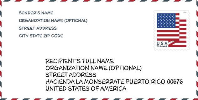
Envelop Voorbeeld

Dit is een voorbeeld van een Amerikaanse postenvelop. U kunt een 5-cijferige postcode of een gedetailleerde 9-cijferige postcode gebruiken om de mail in het volgende adresformaat te kopiëren.
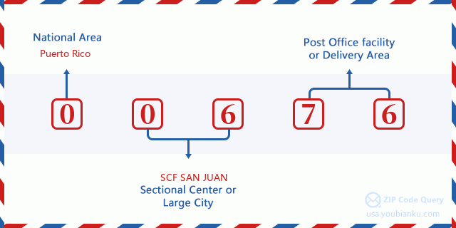
00676 Basisbetekenis
Waar staat elk cijfer van postcode 00676 voor? Het eerste cijfer geeft een nationaal gebied aan, dat varieert van nul voor het noordoosten tot negen voor het verre westen. De 2-3 cijfers zijn de code van een sectiecentrumfaciliteit in die regio. De laatste twee cijfers duiden kleine postkantoren of postzones aan.
Online landkaart

Het is een online kaart van adres Villa Soto, Puerto Rico, United States. U kunt Knopje gebruiken te in/uitzoomen. De kaartinformatie is alleen ter referentie.
Universiteit

This is the ZIP Code 00676 - University page list. Its detail university Name, Street, City, State, ZIP Code, Phone is as below.
| Naam | Straat | Stad | Staat | Postcode | Telefoon |
| Institute of Beauty Occupation and Technology Course | 500 Calle Concepcion Vera | Moca | PR | 00676 | - |
Ziekenhuis

Het is de Postcode 00676 - Ziekenhuis pagina lijst. Het detail Ziekenhuisnaam, straat, stad, staat, postcode, telefoon is zoals hieronder.
- Naam: HOSPITAL SAN CARLOS BORROMEO
- Adres: MOCA
- Stad: CALLE CONCEPCION VERA AYALA #550 S
- Staat: PR
- Postcode: 00676
- Telefoon: (787) 877-8000
School
Dit is de paginalijst van Postcode 00676 - School. Hieronder is het detail van School Naam, Adres, Stad, Staat, Postcode.
| School Naam | Adres | Stad | Staat | Klassen | Postcode |
|---|---|---|---|---|---|
| SUPERIOR CATALINA MORALES FLORES | CARR 110 CALLE CONCEPCION VERA | MOCA | PR | UG | 00676 |
| TOMAS VERA AYALA | CARR 111 KM 4 HM 0 BO PLATA ALTA | MOCA | PR | UG | 00676 |
| CERRO GORDO MEDINA | CARR 420 INT 495 KM 2.0 | MOCA | PR | UG | 00676 |
| CUCHILLAS | CARR 444 KM 3 HM 7 | MOCA | PR | UG | 00676 |
| JUAN DE DIOS QUINONES | CARR 125 KM 9 HM 7 BO VOLADORA | MOCA | PR | UG | 00676 |
| DR EFRAIN SANCHEZ HIDALGO | CALLE MONSENOR JOSE TORRES | MOCA | PR | UG | 00676 |
| MARCELINO RODRIGUEZ ROMAN | CARR 125 KM 0 HM 2 BO VOLADORA | MOCA | PR | UG | 00676 |
| LUIS COLON (ADOLFO BABILONIA) | 230 CALLE ISABELA PUEBLO | MOCA | PR | UG | 00676 |
Population for Postcode 00676

What is the total population in ZIP Code 00676? Below is detail information.
- Population for Postcode 00676: 18,992
- 2010 Bevolking: 40,316
The 2020 demographic statistics are in progress. The current population in ZIP code 00676 is 18,992, and the population in 2010 is 40,316.
Geslacht

In all the statistical population, the male population is 19,778, the female population is 20,538.
- Male Population: 19,778
- Female Population: 20,538
Race

In all the statistical population, the male population is 19,778, the female population is 20,538.
- White Population: 36,842
- Black Population: 2,397
- Hispanic Population: 40,090
- Asian Population: 47
- Hawaiian Population: 14
- Indian Population: 143
- Other Population: 1,793
Leeftijd

In all the statistical population, the White population is 36,842, the Black population is 2,397, the Hispanic population is 40,090, the Asian population is 47, the Hawaiian population is 14, the Indian Ppopulation is 143 and Other population is 1,793.
- Age's Median: 35.1
- Median of male age: 34.3
- Median of female age: 35.8
Households for Postcode 00676
ZIP code 00676 has 14,431 households, with an average number of 2.78 persons per household. The average income per household in Zip code 00676 is 14,146 USD, and the average house value is 96,500 USD.
- Households Per Zipcode: 14,431
- Personen per huishouden: 2.78
- Gemiddelde huiswaarde: 96,500
- Inkomen per huishouden: 14,146
Geographic

The latitude of the Zip code 00676 is 18.385559, the longitude is -67.082204, and the elevation is 186. It has land area of 50.437 square miles, and water area of 0.022 square miles. The time zone for ZIP code 00676 is Atlantic (GMT -04:00). Daylight saving time should be observed in the area where the zip code is located.
- Breedtegraad: 18.385559
- Lengte: -67.082204
- Elevatie: 186
- Landoppervlak: 50.437
- Water Area: 0.022
- Tijd Zone: Atlantic (GMT -04:00)
- Zomertijd: N
Levering

In the ZIP code 00676, there are 6,832 residential delivery mailboxes and centralized units, and 271 commercial delivery mailbox and centralized units, 3,128 single family deliveries and 1,750 multifamily deliveries, and the box count is 11,998. The main post office has city delivery carrier routes for the ZIP code 00676.
- Delivery Residential: 6,832
- Delivery Business: 271
- Delivery Total: 11,998
- Leveringseenheden voor één gezin: 3,128
- Multi Family Delivery Units: 1,750
- Stadsleveringsindicator: Y


Reactie toevoegen