ZIP Code: 80223, Denver, CO
ZIP Code 80223 is located in Denver, Colorado. Its detail State, County, City, Longitude, Latitude, Envelope Example, Population is as below.
ZIP Code 80223 Information

-
-
Country:
U.S. - United States
State:
County FIPS:
08031
County:
City:
City Type ?In many cases, a ZIP Code can have multiple "names", meaning cities, towns, or subdivisions, in its boundaries. However, it will ALWAYS have exactly 1 "default" name. D - Default - This is the "preferred" name - by the USPS - for a city. Each ZIP Code has one - and only one - "default" name. In most cases, this is what people who live in that area call the city as well. A - Acceptable - This name can be used for mailing purposes. Often times alternative names are large neighborhoods or sections of the city/town. In some cases a ZIP Code may have several "acceptable" names which is used to group towns under one ZIP Code. N - Not Acceptable - A "not acceptable" name is, in many cases, a nickname that residents give that location. According to the USPS, you should NOT send mail to that ZIP Code using the "not acceptable" name when mailing.:
D (Default)
ZIP Code:
80223
❓What does D (Default) mean? This is the "preferred" name - by the USPS - for a city. Each ZIP Code has one - and only one - "default" name. In most cases, this is what people who live in that area call the city as well.
-


-
Iconic US Landmark Legacy Designs
Get PNG, SVG, EPS, AI, PDF Versions at Just $0.1
 Download Now
-


ZipCodeCraft
ZIP Code 80223 Plus 4
ZIP Code 5 plus 4 is the extension of 5-digit zip code, It can be used to locate a more detailed location. The last four digits designate segment or one side of a street or an apartment. You can find the ZIP+4 code and corresponding address of the zip code 80223 below.
| ZIP Code 5 Plus 4 | Address |
|---|---|
| 80223-1000 | 2300 W 2ND AVE #1A , DENVER, CO |
| 80223-1000 | 2300 W 2ND AVE #A , DENVER, CO |
| 80223-1001 | 201 YUMA ST, DENVER, CO |
| 80223-1002 | 200 YUMA ST, DENVER, CO |
| 80223-1003 | 301 YUMA ST, DENVER, CO |
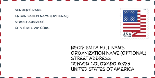
Envelope Example

This is an example of a US zip envelope. You can use a 5-digit zipcode or a detailed 9-digit zipcode to copy the mail in the following address format.
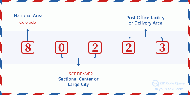
80223 Basic Meaning
What does each digit of ZIP Code 80223 stands for? The first digit designates a national area, which ranges from zero for the Northeast to nine for the far West. The 2-3 digits are the code of a sectional center facility in that region. The last two digits designate small post offices or postal zones.
Online Map

This is online map of the address Denver, Colorado, United States. You may use button to move and zoom in / out. The map information is for reference only.
Museum

This is the ZIP Code 80223 - Museum page list. Its detail Museum Name, Street, City, State, ZIP Code, Phone is as below.
- Name: WILDLIFE WORLD MUSEUM
- Street: 2635 S SANTA FE DR
- City: DENVER
- State: CO
- ZIP Code: 80223
- Phone:
Library

This is the ZIP Code 80223 - Library page list. Its detail Library Name, Address, City, State, ZIP Code, Phone is as below.
- Name: DPL-ATHMAR PARK BRANCH
- Address: 1055 S. TEJON STREET
- City: DENVER
- State: CO - Colorado
- ZIP Code: 80223
- Phone: (303) 935-0721
School

This is the ZIP Code 80223 - School page list. Its detail School Name, Address, City, State, ZIP Code is as below.
| School Name | Address | City | State | Grades | ZIP Code |
|---|---|---|---|---|---|
| Denver Center for International Studies at Fairmon | 520 WEST 3RD AVENUE | DENVER | CO | UG | 80223 |
| 5280 High School | 1200 W MISSISSIPPI AVE | DENVER | CO | UG | 80223 |
| American Indian Academy of Denver | 1862 W. MISSISSIPPI AVENUE | DENVER | CO | UG | 80223 |
Population for ZIP Code 80223

What is the total population in ZIP Code 80223? Below is detail information.
- Population for ZIP Code 80223: 22,920
- 2010 Population: 17,987
The 2020 demographic statistics are in progress. The current population in ZIP code 80223 is 22,920, and the population in 2010 is 17,987.
Gender

In all the statistical population, the male population is 9,244, the female population is 8,743.
- Male Population: 9,244
- Female Population: 8,743
Race

In all the statistical population, the male population is 9,244, the female population is 8,743.
- White Population: 12,730
- Black Population: 795
- Hispanic Population: 10,800
- Asian Population: 528
- Hawaiian Population: 50
- Indian Population: 691
- Other Population: 4,190
Age

In all the statistical population, the White population is 12,730, the Black population is 795, the Hispanic population is 10,800, the Asian population is 528, the Hawaiian population is 50, the Indian Ppopulation is 691 and Other population is 4,190.
- Age's Median: 31.8
- Median of male age: 31.7
- Median of female age: 32.0
Households for ZIP Code 80223
ZIP code 80223 has 6,634 households, with an average number of 2.70 persons per household. The average income per household in Zip code 80223 is 51,431 USD, and the average house value is 259,900 USD.
- Households Per Zipcode: 6,634
- Persons Per Household: 2.70
- Average House Value: 259,900
- Income Per Household: 51,431
Housing Unit

In ZIP code 80223, the growth rank of housing unit is 41, the number of housing unit was 600,008 in 2010 and increased to 619,968 in 2011, the growth increase number is 19,960, the growth increase percentage is 3.3%.
- Growth Rank: 41
- Housing Units Estimate in 2010: 600,008
- Housing Units Estimate in 2011: 619,968
- Growth Increase Number: 19,960
- Growth Increase Percentage: 3.3%
Geographic

The latitude of the Zip code 80223 is 39.692916, the longitude is -105.003914, and the elevation is 5270. It has land area of 5.235 square miles, and water area of 0.032 square miles. The time zone for ZIP code 80223 is Mountain (GMT -07:00). Daylight saving time should be observed in the area where the zip code is located.
- Latitude: 39.692916
- Longitude: -105.003914
- Elevation: 5270
- Land Area: 5.235
- Water Area: 0.032
- Time Zone: Mountain (GMT -07:00)
- Region: West
- Division: Mountain
- Day Light Saving: Y
Congressional District

The Congressional District for ZIP code 80223 is Colorado's 1st congressional district, the Congressional Land Area is 189.62 square mile.
- Congressional District: 1st
- Congressional Land Area: 189.62
Delivery

In the ZIP code 80223, there are 8,489 residential delivery mailboxes and centralized units, and 1,514 commercial delivery mailbox and centralized units, 5,985 single family deliveries and 2,313 multifamily deliveries, and the box count is 10,655. The main post office has city delivery carrier routes for the ZIP code 80223.
- Delivery Residential: 8,489
- Delivery Business: 1,514
- Delivery Total: 10,655
- Single Family Delivery Units: 5,985
- Multi Family Delivery Units: 2,313
- City Delivery Indicator: Y
Business

In ZIP code 80223, the number of business is 1,102, the number of employee is 17,866, the business first quarter payroll is 239,928,000 USD, the business annual payroll is 973,882,000 USD.
- Number Of Businesses: 1,102
- Number Of Employees: 17,866
- Business First Quarter Payroll: 239,928,000
- Business Annual Payroll: 973,882,000
Social Security Benefits

There are 2,345 beneficiaries with benefits in current-payment status for ZIP code 80223, of which 1,580 are retired workers, 400 are disabled workers, 130 are widow(er)s and parents, 90 are spouses and 145 are children. The number of beneficiaries aged 65 or older is 1,720. The total monthly benefits are 2,730,000 USD, of which 1,974,000 USD for retired workers, 151,000 USD for widow(er)s and parents.
- Total Number: 2,345
- Retired workers Number: 1,580
- Disabled workers Number: 400
- Widow(er)s and parents Number: 130
- Spouses Number: 90
- Children Number: 145
- All beneficiaries per month: 2,730,000
- Retired workers per month: 1,974,000
- Widow(er)s and parents per month: 151,000
- Number of beneficiaries aged 65 or older: 1,720


Add new comment