邮政编码: 40122, Fort Knox, KY
邮政编码40122位于 Fort Knox, Kentucky。其详细的的信息:州、县、市、经度、纬度、信封示例、人口如下。

邮政编码40122信息

-
-
国家:
U.S. - 美国
县FIPS:
21093
城市:
区号:
城市类型 ?In many cases, a ZIP Code can have multiple "names", meaning cities, towns, or subdivisions, in its boundaries. However, it will ALWAYS have exactly 1 "default" name. D - Default - This is the "preferred" name - by the USPS - for a city. Each ZIP Code has one - and only one - "default" name. In most cases, this is what people who live in that area call the city as well. A - Acceptable - This name can be used for mailing purposes. Often times alternative names are large neighborhoods or sections of the city/town. In some cases a ZIP Code may have several "acceptable" names which is used to group towns under one ZIP Code. N - Not Acceptable - A "not acceptable" name is, in many cases, a nickname that residents give that location. According to the USPS, you should NOT send mail to that ZIP Code using the "not acceptable" name when mailing.:
D (Default)
邮政编码:
40122
❓D (Default)是什么意思?这是USPS的“首选”城市名称。每个邮政编码都有且仅有一个 “默认”名称。在大多数情况下,这也是当地居民所说的城市。
邮政编码40122加4
ZIP Code 5+4 是5位邮政编码的扩展,可以用来定位更详细的位置。最后四位数字表示路段或街道的一侧或公寓。您可以在下面找到邮政编码 40122 的 ZIP+4 代码和对应地址。
| 邮政编码5加4 | 地址 |
|---|---|
| 40122-5000 | 1600 SPEARHEAD DIVISION AVE, FORT KNOX, KY |
| 40122-5001 | 1600 SPEARHEAD DIVISION AVE, FORT KNOX, KY |
| 40122-5100 | 1600 SPEARHEAD DIVISION AVE #00000100 , FORT KNOX, KY |
| 40122-5101 | 1600 SPEARHEAD DIVISION AVE #00000110 , FORT KNOX, KY |
| 40122-5102 | 1600 SPEARHEAD DIVISION AVE #00000120 , FORT KNOX, KY |
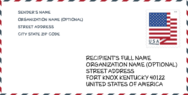
信封例子

这是一个美国邮政信封的示例。当您需要邮寄时,您可以使用5位邮政编码或详细的9位邮政编码来复制示例地址。
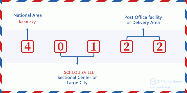
40122基本含义
邮政编码40122的每个数字代表什么?第一个数字表示国家区域,范围从东北部的零到远西部的九。 2-3位数字是该地区的分区中心设施的代码。最后两位数字表示小型邮局或邮政区。
在线地图

这是地址Fort Knox, Kentucky, United States匹配的在线电子地图。您可以使用图中按钮来移动、缩放。该地图信息仅供参考。
地域信息

邮政编码40122的纬度为37.899268,经度为-85.934517,海拔为666。其土地面积为0平方英里,水域为0平方英里。邮政编码40122的时区为Eastern (GMT -05:00)。邮政编码所在的区域应遵守夏令时。
- 纬度: 37.899268
- 经度: -85.934517
- 海拔: 666
- 土地面积: 0
- 水域面积: 0
- 时区: Eastern (GMT -05:00)
- 区域: South
- 区: East South Central
- 夏令时: Y
国会区

邮政编码40122的国会区是Kentucky的2nd国会区,国会土地面积是7177.44平方英里。
- 国会区: 2nd
- 国会土地面积: 7177.44
邮递信息

在邮政编码40122中,有0个住宅邮箱和集中式单位,以及1个商业邮箱和集中式单位,有0个单户邮箱和0个多户邮箱,邮箱总数为989。总邮局有邮政编码为40122的城市快递公司路线。
- 住宅邮箱: 0
- 商业邮箱: 1
- 邮箱总额: 989
- 单户邮箱: 0
- 多户邮箱: 0
- 城市配送路线: Y


添加新评论