郵遞區號: 04014, Cape Porpoise, ME
郵政編碼04014位於 Cape Porpoise, Maine。其詳細的信息:州、縣、市、經度、緯度、信封示例、人口如下。

郵遞區號04014資訊

-
-
國家:
U.S. - 美國
縣FIPS:
23031
區號:
城市類型 ?In many cases, a ZIP Code can have multiple "names", meaning cities, towns, or subdivisions, in its boundaries. However, it will ALWAYS have exactly 1 "default" name. D - Default - This is the "preferred" name - by the USPS - for a city. Each ZIP Code has one - and only one - "default" name. In most cases, this is what people who live in that area call the city as well. A - Acceptable - This name can be used for mailing purposes. Often times alternative names are large neighborhoods or sections of the city/town. In some cases a ZIP Code may have several "acceptable" names which is used to group towns under one ZIP Code. N - Not Acceptable - A "not acceptable" name is, in many cases, a nickname that residents give that location. According to the USPS, you should NOT send mail to that ZIP Code using the "not acceptable" name when mailing.:
D (Default)
郵遞區號:
04014
❓D (Default)是什麼意思?這是USPS的“首選”城市名稱。每個郵政編碼都有且僅有一個“默认”名稱。在大多數情況下,這也是當地居民所說的城市。
郵遞區號04014加4
ZIP Code 5+4 是5位郵政編碼的擴展,可以用來定位更詳細的位置。最後四位數字表示路段或街道的一側或公寓。您可以在下面找到郵政編碼 04014 的 ZIP+4 代碼和對應地址。
| 郵遞區號5加4 | 地址 |
|---|---|
| 04014-6912 | 167 MAIN ST, CAPE PORPOISE, ME |
| 04014-7001 | PO BOX 7001, CAPE PORPOISE, ME |
| 04014-7071 | PO BOX 7071, CAPE PORPOISE, ME |
| 04014-7151 | PO BOX 7151, CAPE PORPOISE, ME |
| 04014-7211 | PO BOX 7211, CAPE PORPOISE, ME |
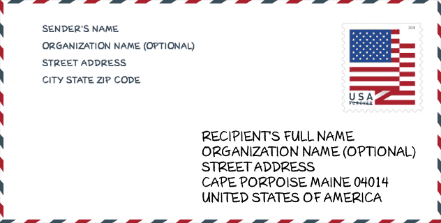
信封例子

這是一個美國郵政信封的示例。當您需要郵寄時,您可以使用5位郵政編碼或詳細的9位郵政編碼來複製示例地址。
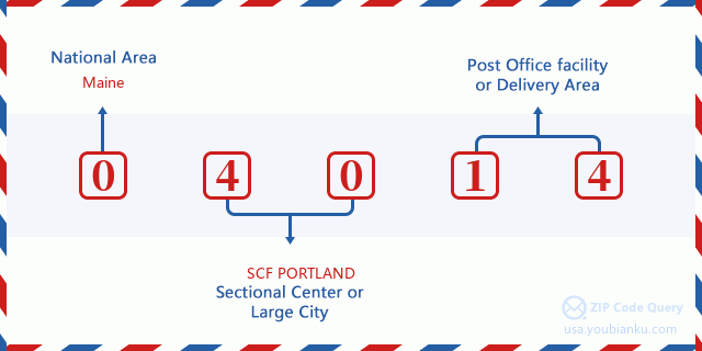
04014基本含義
郵政編碼04014的每個數字代表什麼?第一個數字表示國家地區,範圍從東北部的零到遠西部的九。 2-3位數字是該地區的分區中心設施的代碼。最後兩位數字表示小型郵局或郵政區。
在線地圖

这是地址Cape Porpoise, Maine, United States匹配的在线电子地图。您可以使用图中按钮来移动、缩放。该地图信息仅供参考。
地域信息

郵政編碼04014的緯度為43.370600,經度為-70.437900,海拔為20。其土地面積為0平方英里,水域為0平方英里。郵政編碼04014的時區為Eastern (GMT -05:00)。郵政編碼所在的區域應遵守夏令時。
- 緯度: 43.370600
- 經度: -70.437900
- 海拔: 20
- 土地面積: 0
- 水域面積: 0
- 時區: Eastern (GMT -05:00)
- 區域: Northeast
- 區: New England
- 夏令時: Y
國會區

郵政編碼04014的國會區為Maine的1st國會區,國會土地面積為3285.52平方英里。
- 國會區: 1st
- 國會土地面積: 3285.52
郵遞信息

在郵政編碼04014中,有0個住宅送貨信箱和集中式單元,以及0個商業送貨信箱和集中式單元,有0個單戶家庭送貨信箱和0個多戶家庭送貨信箱,郵箱總數為249。總郵局沒有郵政編碼為04014的城市快遞公司路線。
- 住宅郵箱: 0
- 商業郵箱: 0
- 郵箱總額: 249
- 單戶郵箱: 0
- 多戶郵箱: 0
- 城市配送路線: N
商業

郵政編碼04014中,企業數量為4,員工數量為9,企業第一季度工資單為36,000 USD,企業年度工資單為421,000 USD。
- 企業數量: 4
- 在職員工人數: 9
- 企業第一季度工資單: 36,000
- 企業年度工資單: 421,000


發表新回應