United States ZIP Code: 00660
This is the Puerto Rico ZIP Code 00660 page list. Its detail State, County, City, Longitude, Latitude, Envelope Example, Population is as below.

ZIP Code 00660 Information

-
-
Country:
U.S. - United States
State:
State FIPS:
72
ZIP Code:
00660
ZIP Type:
S (Standard)
❓What does S (Standard) mean? A "standard" ZIP Code is what most people think of when they talk about ZIP Codes - essentially a town, city, or a division of a city that has mail service.
-


-
Iconic US Landmark Legacy Designs
Get PNG, SVG, EPS, AI, PDF Versions at Just $0.1
 Download Now
-


ZipCodeCraft
ZIP Code 00660 - City

This is the city information corresponding to 00660:
| State | County | City | City Type ?In many cases, a ZIP Code can have multiple "names", meaning cities, towns, or subdivisions, in its boundaries. However, it will ALWAYS have exactly 1 "default" name. D - Default - This is the "preferred" name - by the USPS - for a city. Each ZIP Code has one - and only one - "default" name. In most cases, this is what people who live in that area call the city as well. A - Acceptable - This name can be used for mailing purposes. Often times alternative names are large neighborhoods or sections of the city/town. In some cases a ZIP Code may have several "acceptable" names which is used to group towns under one ZIP Code. N - Not Acceptable - A "not acceptable" name is, in many cases, a nickname that residents give that location. According to the USPS, you should NOT send mail to that ZIP Code using the "not acceptable" name when mailing. | ZIP Code |
|---|---|---|---|---|
| PR | Hormigueros | Bo Lavadero | N (Not Acceptable) | 00660 |
| PR | Hormigueros | Colinas Del Oeste | N (Not Acceptable) | 00660 |
| PR | Hormigueros | Est Del Rio | N (Not Acceptable) | 00660 |
| PR | Hormigueros | Hacienda La Monserrate | N (Not Acceptable) | 00660 |
| PR | Hormigueros | Haciendas Constancia | N (Not Acceptable) | 00660 |
| PR | Hormigueros | Hormigueros | D (Default) | 00660 |
| PR | Hormigueros | Mans La Monserrate | N (Not Acceptable) | 00660 |
| PR | Hormigueros | Parc San Romualdo | N (Not Acceptable) | 00660 |
| PR | Hormigueros | Paseo Los Peregrinos | N (Not Acceptable) | 00660 |
| PR | Hormigueros | Urb Montebello | N (Not Acceptable) | 00660 |
| PR | Hormigueros | Urb Paseo La Ceiba | N (Not Acceptable) | 00660 |
| PR | Hormigueros | Urb Verdun | N (Not Acceptable) | 00660 |
| PR | Hormigueros | Urb Verdun Ii | N (Not Acceptable) | 00660 |
| PR | Hormigueros | Valle Hermoso | N (Not Acceptable) | 00660 |
| PR | Hormigueros | Villa Zoraida | N (Not Acceptable) | 00660 |
❓What does D (Default) mean? This is the "preferred" name - by the USPS - for a city. Each ZIP Code has one - and only one - "default" name. In most cases, this is what people who live in that area call the city as well.
❓What does N (Not Acceptable) mean? A "not acceptable" name is, in many cases, a nickname that residents give that location. According to the USPS, you should NOT send mail to that ZIP Code using the "not acceptable" name when mailing.
ZIP Code 00660 Plus 4
ZIP Code 5 plus 4 is the extension of 5-digit zip code, It can be used to locate a more detailed location. The last four digits designate segment or one side of a street or an apartment. You can find the ZIP+4 code and corresponding address of the zip code 00660 below.
| ZIP Code 5 Plus 4 | Address |
|---|---|
| 00660-0001 | PO BOX 1, HORMIGUEROS, PR |
| 00660-0121 | PO BOX 121, HORMIGUEROS, PR |
| 00660-0241 | PO BOX 241, HORMIGUEROS, PR |
| 00660-0361 | PO BOX 361, HORMIGUEROS, PR |
| 00660-0481 | PO BOX 481, HORMIGUEROS, PR |
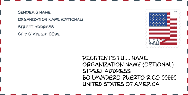
Envelope Example

This is an example of a US zip envelope. You can use a 5-digit zipcode or a detailed 9-digit zipcode to copy the mail in the following address format.
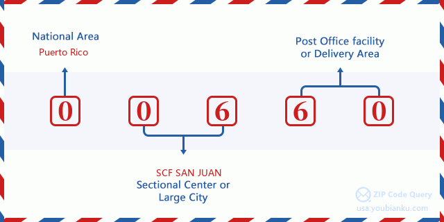
00660 Basic Meaning
What does each digit of ZIP Code 00660 stands for? The first digit designates a national area, which ranges from zero for the Northeast to nine for the far West. The 2-3 digits are the code of a sectional center facility in that region. The last two digits designate small post offices or postal zones.
Online Map

This is online map of the address Villa Zoraida, Puerto Rico, United States. You may use button to move and zoom in / out. The map information is for reference only.
School

This is the ZIP Code 00660 - School page list. Its detail School Name, Address, City, State, ZIP Code is as below.
| School Name | Address | City | State | Grades | ZIP Code |
|---|---|---|---|---|---|
| ELEMENTAL NUEVA | CARR 309 KM 1.9 INTERIOR BO JUANAJIBO | HORMIGUEROS | PR | UG | 00660 |
| SEGUNDO RUIZ BELVIS | 16 CALLE SEGUNDO RUIZ BELVIS | HORMIGUEROS | PR | UG | 00660 |
| SU ALFREDO DORRINGTON | URB VALLE HERMOSO 34 CALLE FLAMBOYAN | HORMIGUEROS | PR | UG | 00660 |
| RAMON E. RODRIGUEZ DIAZ | CALLE COMERCIO URB. VERDUN | HORMIGUEROS | PR | UG | 00660 |
Population for ZIP Code 00660

What is the total population in ZIP Code 00660? Below is detail information.
- Population for ZIP Code 00660: 12,145
- 2010 Population: 17,250
The 2020 demographic statistics are in progress. The current population in ZIP code 00660 is 12,145, and the population in 2010 is 17,250.
Gender

In all the statistical population, the male population is 8,027, the female population is 9,223.
- Male Population: 8,027
- Female Population: 9,223
Race

In all the statistical population, the male population is 8,027, the female population is 9,223.
- White Population: 14,390
- Black Population: 1,732
- Hispanic Population: 17,158
- Asian Population: 30
- Hawaiian Population: 15
- Indian Population: 149
- Other Population: 1,455
Age

In all the statistical population, the White population is 14,390, the Black population is 1,732, the Hispanic population is 17,158, the Asian population is 30, the Hawaiian population is 15, the Indian Ppopulation is 149 and Other population is 1,455.
- Age's Median: 41.5
- Median of male age: 39.0
- Median of female age: 43.9
Households for ZIP Code 00660
ZIP code 00660 has 6,821 households, with an average number of 2.51 persons per household. The average income per household in Zip code 00660 is 19,394 USD, and the average house value is 101,600 USD.
- Households Per Zipcode: 6,821
- Persons Per Household: 2.51
- Average House Value: 101,600
- Income Per Household: 19,394
Geographic

The latitude of the Zip code 00660 is 18.138245, the longitude is -67.111993, and the elevation is 71. It has land area of 11.346 square miles, and water area of 0 square miles. The time zone for ZIP code 00660 is Atlantic (GMT -04:00). Daylight saving time should be observed in the area where the zip code is located.
- Latitude: 18.138245
- Longitude: -67.111993
- Elevation: 71
- Land Area: 11.346
- Water Area: 0
- Time Zone: Atlantic (GMT -04:00)
- Day Light Saving: N
Delivery

In the ZIP code 00660, there are 4,839 residential delivery mailboxes and centralized units, and 150 commercial delivery mailbox and centralized units, 2,865 single family deliveries and 937 multifamily deliveries, and the box count is 7,374. The main post office has city delivery carrier routes for the ZIP code 00660.
- Delivery Residential: 4,839
- Delivery Business: 150
- Delivery Total: 7,374
- Single Family Delivery Units: 2,865
- Multi Family Delivery Units: 937
- City Delivery Indicator: Y


Add new comment