United States ZIP Code: 00718
This is the Puerto Rico ZIP Code 00718 page list. Its detail State, County, City, Longitude, Latitude, Envelope Example, Population is as below.

ZIP Code 00718 Information

-
-
Country:
U.S. - United States
State:
State FIPS:
72
ZIP Code:
00718
ZIP Type:
S (Standard)
❓What does S (Standard) mean? A "standard" ZIP Code is what most people think of when they talk about ZIP Codes - essentially a town, city, or a division of a city that has mail service.
-


-
Iconic US Landmark Legacy Designs
Get PNG, SVG, EPS, AI, PDF Versions at Just $0.1
 Download Now
-


ZipCodeCraft
ZIP Code 00718 - City

This is the city information corresponding to 00718:
| State | County | City | City Type ?In many cases, a ZIP Code can have multiple "names", meaning cities, towns, or subdivisions, in its boundaries. However, it will ALWAYS have exactly 1 "default" name. D - Default - This is the "preferred" name - by the USPS - for a city. Each ZIP Code has one - and only one - "default" name. In most cases, this is what people who live in that area call the city as well. A - Acceptable - This name can be used for mailing purposes. Often times alternative names are large neighborhoods or sections of the city/town. In some cases a ZIP Code may have several "acceptable" names which is used to group towns under one ZIP Code. N - Not Acceptable - A "not acceptable" name is, in many cases, a nickname that residents give that location. According to the USPS, you should NOT send mail to that ZIP Code using the "not acceptable" name when mailing. | ZIP Code |
|---|---|---|---|---|
| PR | Naguabo | Bo Mariana | N (Not Acceptable) | 00718 |
| PR | Naguabo | Brisas De Naguabo | N (Not Acceptable) | 00718 |
| PR | Naguabo | Hacienda Grande | N (Not Acceptable) | 00718 |
| PR | Naguabo | Jard De Esperanza | N (Not Acceptable) | 00718 |
| PR | Naguabo | Jard De La Via | N (Not Acceptable) | 00718 |
| PR | Naguabo | Jard Del Este | N (Not Acceptable) | 00718 |
| PR | Naguabo | Mans Playa Hucares | N (Not Acceptable) | 00718 |
| PR | Naguabo | Naguabo | D (Default) | 00718 |
| PR | Naguabo | Repto Santiago | N (Not Acceptable) | 00718 |
| PR | Naguabo | Urb Casabella | N (Not Acceptable) | 00718 |
| PR | Naguabo | Urb City Palace | N (Not Acceptable) | 00718 |
| PR | Naguabo | Urb Diplo | N (Not Acceptable) | 00718 |
| PR | Naguabo | Urb Juan Mendoza | N (Not Acceptable) | 00718 |
| PR | Naguabo | Urb Promised Land | N (Not Acceptable) | 00718 |
| PR | Naguabo | Urb Ramon Rivero | N (Not Acceptable) | 00718 |
| PR | Naguabo | Urb Santo Tomas | N (Not Acceptable) | 00718 |
| PR | Naguabo | Villa Del Rosario | N (Not Acceptable) | 00718 |
❓What does D (Default) mean? This is the "preferred" name - by the USPS - for a city. Each ZIP Code has one - and only one - "default" name. In most cases, this is what people who live in that area call the city as well.
❓What does N (Not Acceptable) mean? A "not acceptable" name is, in many cases, a nickname that residents give that location. According to the USPS, you should NOT send mail to that ZIP Code using the "not acceptable" name when mailing.
ZIP Code 00718 Plus 4
ZIP Code 5 plus 4 is the extension of 5-digit zip code, It can be used to locate a more detailed location. The last four digits designate segment or one side of a street or an apartment. You can find the ZIP+4 code and corresponding address of the zip code 00718 below.
| ZIP Code 5 Plus 4 | Address |
|---|---|
| 00718-0001 | PO BOX 1, NAGUABO, PR |
| 00718-0121 | PO BOX 121, NAGUABO, PR |
| 00718-0241 | PO BOX 241, NAGUABO, PR |
| 00718-0361 | PO BOX 361, NAGUABO, PR |
| 00718-0481 | PO BOX 481, NAGUABO, PR |
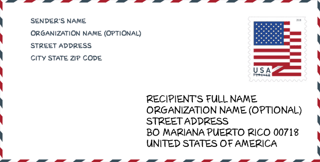
Envelope Example

This is an example of a US zip envelope. You can use a 5-digit zipcode or a detailed 9-digit zipcode to copy the mail in the following address format.
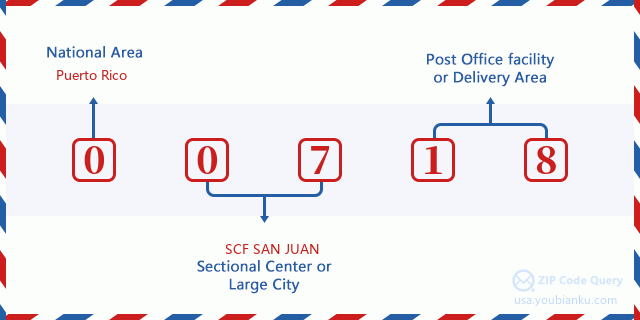
00718 Basic Meaning
What does each digit of ZIP Code 00718 stands for? The first digit designates a national area, which ranges from zero for the Northeast to nine for the far West. The 2-3 digits are the code of a sectional center facility in that region. The last two digits designate small post offices or postal zones.
Online Map

This is online map of the address Villa Del Rosario, Puerto Rico, United States. You may use button to move and zoom in / out. The map information is for reference only.
School

This is the ZIP Code 00718 - School page list. Its detail School Name, Address, City, State, ZIP Code is as below.
| School Name | Address | City | State | Grades | ZIP Code |
|---|---|---|---|---|---|
| EUGENIO BRAC | 2 CALLE ANTONIO RIOS | NAGUABO | PR | UG | 00718 |
| FIDELINA MELENDEZ MONSANTO | CALLE ANTONIO RIOS LATERAL 7 | NAGUABO | PR | UG | 00718 |
| JUAN JOSE MAUNEZ | CALLE BUENOS AIRES FINAL | NAGUABO | PR | UG | 00718 |
| LUTGARDA RIVERA REYES (FLORIDA) | CARR 969 KM 2 HM 0 BO FLORIDA | NAGUABO | PR | UG | 00718 |
| QUEBRADA GRANDE | CALLE 3 BO DUQUE ESQ 8 PARCELAS VIEJAS | NAGUABO | PR | UG | 00718 |
| FERMIN DELGADO DIAZ (SU BO PENA POBRE) | CARR #31 INT #850 BO PENA POBRE SEC-HIGUERILLO | NAGUABO | PR | UG | 00718 |
| SU SILVERIO GARCIA | CARR 3 KM 9 HM 4 BO DAGUAO | NAGUABO | PR | UG | 00718 |
Population for ZIP Code 00718

What is the total population in ZIP Code 00718? Below is detail information.
- Population for ZIP Code 00718: 16,429
- 2010 Population: 26,606
The 2020 demographic statistics are in progress. The current population in ZIP code 00718 is 16,429, and the population in 2010 is 26,606.
Gender

In all the statistical population, the male population is 12,769, the female population is 13,837.
- Male Population: 12,769
- Female Population: 13,837
Race

In all the statistical population, the male population is 12,769, the female population is 13,837.
- White Population: 19,612
- Black Population: 4,796
- Hispanic Population: 26,398
- Asian Population: 84
- Hawaiian Population: 25
- Indian Population: 214
- Other Population: 2,796
Age

In all the statistical population, the White population is 19,612, the Black population is 4,796, the Hispanic population is 26,398, the Asian population is 84, the Hawaiian population is 25, the Indian Ppopulation is 214 and Other population is 2,796.
- Age's Median: 34.3
- Median of male age: 33.3
- Median of female age: 35.1
Households for ZIP Code 00718
ZIP code 00718 has 9,715 households, with an average number of 2.73 persons per household. The average income per household in Zip code 00718 is 19,318 USD, and the average house value is 91,400 USD.
- Households Per Zipcode: 9,715
- Persons Per Household: 2.73
- Average House Value: 91,400
- Income Per Household: 19,318
Geographic

The latitude of the Zip code 00718 is 18.250050, the longitude is -65.784727, and the elevation is 483. It has land area of 45.24 square miles, and water area of 1.335 square miles. The time zone for ZIP code 00718 is Atlantic (GMT -04:00). Daylight saving time should be observed in the area where the zip code is located.
- Latitude: 18.250050
- Longitude: -65.784727
- Elevation: 483
- Land Area: 45.24
- Water Area: 1.335
- Time Zone: Atlantic (GMT -04:00)
- Day Light Saving: N
Delivery

In the ZIP code 00718, there are 6,018 residential delivery mailboxes and centralized units, and 120 commercial delivery mailbox and centralized units, 2,684 single family deliveries and 1,986 multifamily deliveries, and the box count is 7,292. The main post office has city delivery carrier routes for the ZIP code 00718.
- Delivery Residential: 6,018
- Delivery Business: 120
- Delivery Total: 7,292
- Single Family Delivery Units: 2,684
- Multi Family Delivery Units: 1,986
- City Delivery Indicator: Y


Add new comment