United States ZIP Code: 00719
This is the Puerto Rico ZIP Code 00719 page list. Its detail State, County, City, Longitude, Latitude, Envelope Example, Population is as below.

ZIP Code 00719 Information

-
-
Country:
U.S. - United States
State:
State FIPS:
72
ZIP Code:
00719
ZIP Type:
S (Standard)
❓What does S (Standard) mean? A "standard" ZIP Code is what most people think of when they talk about ZIP Codes - essentially a town, city, or a division of a city that has mail service.
-


-
Iconic US Landmark Legacy Designs
Get PNG, SVG, EPS, AI, PDF Versions at Just $0.1
 Download Now
-


ZipCodeCraft
ZIP Code 00719 - City

This is the city information corresponding to 00719:
| State | County | City | City Type ?In many cases, a ZIP Code can have multiple "names", meaning cities, towns, or subdivisions, in its boundaries. However, it will ALWAYS have exactly 1 "default" name. D - Default - This is the "preferred" name - by the USPS - for a city. Each ZIP Code has one - and only one - "default" name. In most cases, this is what people who live in that area call the city as well. A - Acceptable - This name can be used for mailing purposes. Often times alternative names are large neighborhoods or sections of the city/town. In some cases a ZIP Code may have several "acceptable" names which is used to group towns under one ZIP Code. N - Not Acceptable - A "not acceptable" name is, in many cases, a nickname that residents give that location. According to the USPS, you should NOT send mail to that ZIP Code using the "not acceptable" name when mailing. | ZIP Code |
|---|---|---|---|---|
| PR | Naranjito | Jard De Naranjito | N (Not Acceptable) | 00719 |
| PR | Naranjito | Naranjito | D (Default) | 00719 |
| PR | Naranjito | Sect Chevres | N (Not Acceptable) | 00719 |
❓What does D (Default) mean? This is the "preferred" name - by the USPS - for a city. Each ZIP Code has one - and only one - "default" name. In most cases, this is what people who live in that area call the city as well.
❓What does N (Not Acceptable) mean? A "not acceptable" name is, in many cases, a nickname that residents give that location. According to the USPS, you should NOT send mail to that ZIP Code using the "not acceptable" name when mailing.
ZIP Code 00719 Plus 4
ZIP Code 5 plus 4 is the extension of 5-digit zip code, It can be used to locate a more detailed location. The last four digits designate segment or one side of a street or an apartment. You can find the ZIP+4 code and corresponding address of the zip code 00719 below.
| ZIP Code 5 Plus 4 | Address |
|---|---|
| 00719-0001 | PO BOX 1, NARANJITO, PR |
| 00719-0121 | PO BOX 121, NARANJITO, PR |
| 00719-0241 | PO BOX 241, NARANJITO, PR |
| 00719-0361 | PO BOX 361, NARANJITO, PR |
| 00719-0481 | PO BOX 481, NARANJITO, PR |
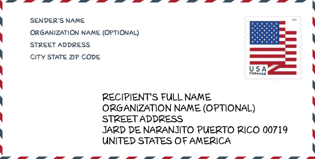
Envelope Example

This is an example of a US zip envelope. You can use a 5-digit zipcode or a detailed 9-digit zipcode to copy the mail in the following address format.
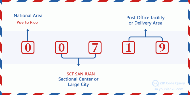
00719 Basic Meaning
What does each digit of ZIP Code 00719 stands for? The first digit designates a national area, which ranges from zero for the Northeast to nine for the far West. The 2-3 digits are the code of a sectional center facility in that region. The last two digits designate small post offices or postal zones.
Online Map

This is online map of the address Sect Chevres, Puerto Rico, United States. You may use button to move and zoom in / out. The map information is for reference only.
School

This is the ZIP Code 00719 - School page list. Its detail School Name, Address, City, State, ZIP Code is as below.
| School Name | Address | City | State | Grades | ZIP Code |
|---|---|---|---|---|---|
| FRANCISCO MORALES | CARR 152 CALLE GEORGETTI INTERIOR | NARANJITO | PR | UG | 00719 |
| BERNARDA ROBLES DE HEVIA | CARR 167 KM 7 HM 7 BO PARCELAS | NARANJITO | PR | UG | 00719 |
| ROSA LUZ ZAYAS (CEDRO ARRIBA) | CARR 809 KM 2 HM 9 BO CEDRO ARRIBA | NARANJITO | PR | UG | 00719 |
| SU ADOLFO GARCIA | CARR 165 KM 1 HM 9 BO LOMAS | NARANJITO | PR | UG | 00719 |
| SU PEDRO FERNANDEZ | CARR 152 KM 10 HM 5 BO CEDRO ARRIBA | NARANJITO | PR | UG | 00719 |
| FRANCISCO ROQUE MUNOZ | CARR 814 KM 4 BO ANONES | NARANJITO | PR | UG | 00719 |
| RUBEN RODRIGUEZ FIGUEROA | CARR #164 BO NUEVO | NARANJITO | PR | UG | 00719 |
| FRANCISCO LOPEZ CRUZ | CARR #164 KM 3 HM 1 | NARANJITO | PR | UG | 00719 |
| COLEEN VAZQUEZ URRUTIA | CARR 164 KM 7 HM 1 BO ACHIOTE | NARANJITO | PR | UG | 00719 |
| MERCEDES ROSADO | CARR 152 CALLE GEORGETTY | NARANJITO | PR | UG | 00719 |
| SILVESTRE MARTINEZ | CARR 826 KM 12 HM 1 BO GUADIANA COM LAGO LA PLATA | NARANJITO | PR | KG-08 | 00719 |
Population for ZIP Code 00719

What is the total population in ZIP Code 00719? Below is detail information.
- Population for ZIP Code 00719: 13,937
- 2010 Population: 30,990
The 2020 demographic statistics are in progress. The current population in ZIP code 00719 is 13,937, and the population in 2010 is 30,990.
Gender

In all the statistical population, the male population is 15,337, the female population is 15,653.
- Male Population: 15,337
- Female Population: 15,653
Race

In all the statistical population, the male population is 15,337, the female population is 15,653.
- White Population: 26,969
- Black Population: 2,672
- Hispanic Population: 30,846
- Asian Population: 48
- Hawaiian Population: 13
- Indian Population: 295
- Other Population: 2,155
Age

In all the statistical population, the White population is 26,969, the Black population is 2,672, the Hispanic population is 30,846, the Asian population is 48, the Hawaiian population is 13, the Indian Ppopulation is 295 and Other population is 2,155.
- Age's Median: 35.1
- Median of male age: 34.2
- Median of female age: 36.3
Households for ZIP Code 00719
ZIP code 00719 has 10,357 households, with an average number of 2.98 persons per household. The average income per household in Zip code 00719 is 19,757 USD, and the average house value is 90,300 USD.
- Households Per Zipcode: 10,357
- Persons Per Household: 2.98
- Average House Value: 90,300
- Income Per Household: 19,757
Geographic

The latitude of the Zip code 00719 is 18.278197, the longitude is -66.248617, and the elevation is 1708. It has land area of 28.003 square miles, and water area of 0.347 square miles. The time zone for ZIP code 00719 is Atlantic (GMT -04:00). Daylight saving time should be observed in the area where the zip code is located.
- Latitude: 18.278197
- Longitude: -66.248617
- Elevation: 1708
- Land Area: 28.003
- Water Area: 0.347
- Time Zone: Atlantic (GMT -04:00)
- Day Light Saving: N
Delivery

In the ZIP code 00719, there are 4,677 residential delivery mailboxes and centralized units, and 232 commercial delivery mailbox and centralized units, 2,268 single family deliveries and 933 multifamily deliveries, and the box count is 7,045. The main post office has city delivery carrier routes for the ZIP code 00719.
- Delivery Residential: 4,677
- Delivery Business: 232
- Delivery Total: 7,045
- Single Family Delivery Units: 2,268
- Multi Family Delivery Units: 933
- City Delivery Indicator: Y


Add new comment