United States ZIP Code: 00783
This is the Puerto Rico ZIP Code 00783 page list. Its detail State, County, City, Longitude, Latitude, Envelope Example, Population is as below.

ZIP Code 00783 Information

-
-
Country:
U.S. - United States
State:
State FIPS:
72
Area Code:
ZIP Code:
00783
ZIP Type:
S (Standard)
❓What does S (Standard) mean? A "standard" ZIP Code is what most people think of when they talk about ZIP Codes - essentially a town, city, or a division of a city that has mail service.
-


-
Iconic US Landmark Legacy Designs
Get PNG, SVG, EPS, AI, PDF Versions at Just $0.1
 Download Now
-


ZipCodeCraft
ZIP Code 00783 - City

This is the city information corresponding to 00783:
| State | County | City | City Type ?In many cases, a ZIP Code can have multiple "names", meaning cities, towns, or subdivisions, in its boundaries. However, it will ALWAYS have exactly 1 "default" name. D - Default - This is the "preferred" name - by the USPS - for a city. Each ZIP Code has one - and only one - "default" name. In most cases, this is what people who live in that area call the city as well. A - Acceptable - This name can be used for mailing purposes. Often times alternative names are large neighborhoods or sections of the city/town. In some cases a ZIP Code may have several "acceptable" names which is used to group towns under one ZIP Code. N - Not Acceptable - A "not acceptable" name is, in many cases, a nickname that residents give that location. According to the USPS, you should NOT send mail to that ZIP Code using the "not acceptable" name when mailing. | ZIP Code |
|---|---|---|---|---|
| PR | Corozal | Bda Sostre | N (Not Acceptable) | 00783 |
| PR | Corozal | Bo Pueblo | N (Not Acceptable) | 00783 |
| PR | Corozal | Colinas De Corozal | N (Not Acceptable) | 00783 |
| PR | Corozal | Corozal | D (Default) | 00783 |
| PR | Corozal | Ext Sylvia | N (Not Acceptable) | 00783 |
| PR | Corozal | Loma Linda | N (Not Acceptable) | 00783 |
| PR | Corozal | Sect Cienagueta | N (Not Acceptable) | 00783 |
| PR | Corozal | Urb Cerromonte | N (Not Acceptable) | 00783 |
| PR | Corozal | Urb Cibuco | N (Not Acceptable) | 00783 |
| PR | Corozal | Urb El Centro | N (Not Acceptable) | 00783 |
| PR | Corozal | Urb Las Brisas | N (Not Acceptable) | 00783 |
| PR | Corozal | Urb Maria Del Carmen | N (Not Acceptable) | 00783 |
| PR | Corozal | Urb Monterey | N (Not Acceptable) | 00783 |
| PR | Corozal | Urb Monteverde | N (Not Acceptable) | 00783 |
| PR | Corozal | Urb San Feliz | N (Not Acceptable) | 00783 |
| PR | Corozal | Urb Sobrino | N (Not Acceptable) | 00783 |
| PR | Corozal | Urb Sylvia | N (Not Acceptable) | 00783 |
| PR | Corozal | Valle De Aramana | N (Not Acceptable) | 00783 |
❓What does D (Default) mean? This is the "preferred" name - by the USPS - for a city. Each ZIP Code has one - and only one - "default" name. In most cases, this is what people who live in that area call the city as well.
❓What does N (Not Acceptable) mean? A "not acceptable" name is, in many cases, a nickname that residents give that location. According to the USPS, you should NOT send mail to that ZIP Code using the "not acceptable" name when mailing.
ZIP Code 00783 Plus 4
ZIP Code 5 plus 4 is the extension of 5-digit zip code, It can be used to locate a more detailed location. The last four digits designate segment or one side of a street or an apartment. You can find the ZIP+4 code and corresponding address of the zip code 00783 below.
| ZIP Code 5 Plus 4 | Address |
|---|---|
| 00783-0001 | PO BOX 1, COROZAL, PR |
| 00783-0121 | PO BOX 121, COROZAL, PR |
| 00783-0241 | PO BOX 241, COROZAL, PR |
| 00783-0361 | PO BOX 361, COROZAL, PR |
| 00783-0481 | PO BOX 481, COROZAL, PR |
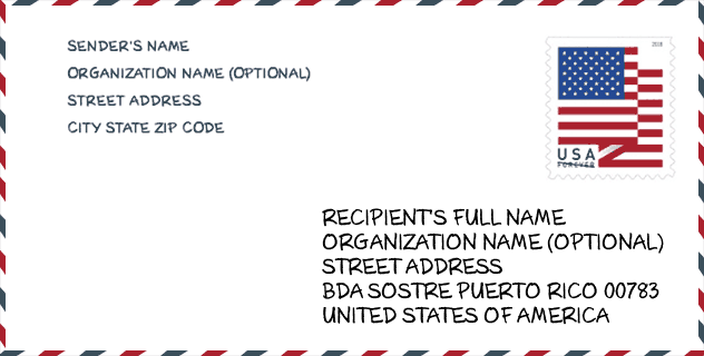
Envelope Example

This is an example of a US zip envelope. You can use a 5-digit zipcode or a detailed 9-digit zipcode to copy the mail in the following address format.
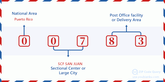
00783 Basic Meaning
What does each digit of ZIP Code 00783 stands for? The first digit designates a national area, which ranges from zero for the Northeast to nine for the far West. The 2-3 digits are the code of a sectional center facility in that region. The last two digits designate small post offices or postal zones.
Online Map

This is online map of the address Valle De Aramana, Puerto Rico, United States. You may use button to move and zoom in / out. The map information is for reference only.
School

This is the ZIP Code 00783 - School page list. Its detail School Name, Address, City, State, ZIP Code is as below.
| School Name | Address | City | State | Grades | ZIP Code |
|---|---|---|---|---|---|
| MANUEL BOU GALI | CARR 891 KM 13 HM 2 | COROZAL | PR | UG | 00783 |
| EMILIO R. DELGADO | CARR 159 KM 13 | COROZAL | PR | UG | 00783 |
| FIDEL LOPEZ COLON | BO PUEBLO | COROZAL | PR | UG | 00783 |
| GENARO BOU | CARR 818 INTERIOR BO CIBUCO | COROZAL | PR | UG | 00783 |
| SU JULIAN MARRERO | CARR 164 KM 14 BO PALMAREJO | COROZAL | PR | UG | 00783 |
| DR. JOSE PADIN | CARR 565 KM 6 BO CUCHILLAS | COROZAL | PR | UG | 00783 |
| SU NICOLAS RODRIGUEZ | CARR 568 KM 30 HM 1 BO PADILLA | COROZAL | PR | UG | 00783 |
| SU DEMETRIO RIVERA | CARR 802 BO PALMARITO | COROZAL | PR | UG | 00783 |
| PABLO DAVID BURGOS MARRERO (NUEVA SUP CON DEPART VOCACIONAL) | PR-159 INT CAMINO ALBINO BO ABRAS | COROZAL | PR | UG | 00783 |
Population for ZIP Code 00783

What is the total population in ZIP Code 00783? Below is detail information.
- Population for ZIP Code 00783: 18,197
- 2010 Population: 36,557
The 2020 demographic statistics are in progress. The current population in ZIP code 00783 is 18,197, and the population in 2010 is 36,557.
Gender

In all the statistical population, the male population is 17,825, the female population is 18,732.
- Male Population: 17,825
- Female Population: 18,732
Race

In all the statistical population, the male population is 17,825, the female population is 18,732.
- White Population: 31,726
- Black Population: 2,232
- Hispanic Population: 36,350
- Asian Population: 41
- Hawaiian Population: 21
- Indian Population: 167
- Other Population: 3,041
Age

In all the statistical population, the White population is 31,726, the Black population is 2,232, the Hispanic population is 36,350, the Asian population is 41, the Hawaiian population is 21, the Indian Ppopulation is 167 and Other population is 3,041.
- Age's Median: 34.8
- Median of male age: 33.6
- Median of female age: 35.8
Households for ZIP Code 00783
ZIP code 00783 has 12,255 households, with an average number of 2.97 persons per household. The average income per household in Zip code 00783 is 14,748 USD, and the average house value is 89,400 USD.
- Households Per Zipcode: 12,255
- Persons Per Household: 2.97
- Average House Value: 89,400
- Income Per Household: 14,748
Geographic

The latitude of the Zip code 00783 is 18.304629, the longitude is -66.330493, and the elevation is 1093. It has land area of 41.841 square miles, and water area of 0.006 square miles. The time zone for ZIP code 00783 is Atlantic (GMT -04:00). Daylight saving time should be observed in the area where the zip code is located.
- Latitude: 18.304629
- Longitude: -66.330493
- Elevation: 1093
- Land Area: 41.841
- Water Area: 0.006
- Time Zone: Atlantic (GMT -04:00)
- Day Light Saving: N
Delivery

In the ZIP code 00783, there are 6,127 residential delivery mailboxes and centralized units, and 234 commercial delivery mailbox and centralized units, 3,523 single family deliveries and 1,317 multifamily deliveries, and the box count is 8,650. The main post office has city delivery carrier routes for the ZIP code 00783.
- Delivery Residential: 6,127
- Delivery Business: 234
- Delivery Total: 8,650
- Single Family Delivery Units: 3,523
- Multi Family Delivery Units: 1,317
- City Delivery Indicator: Y


Add new comment