United States ZIP Code: 00917
This is the Puerto Rico ZIP Code 00917 page list. Its detail State, County, City, Longitude, Latitude, Envelope Example, Population is as below.

ZIP Code 00917 Information

-
-
Country:
U.S. - United States
State:
State FIPS:
72
Area Code:
ZIP Code:
00917
ZIP Type:
S (Standard)
❓What does S (Standard) mean? A "standard" ZIP Code is what most people think of when they talk about ZIP Codes - essentially a town, city, or a division of a city that has mail service.
-


-
Iconic US Landmark Legacy Designs
Get PNG, SVG, EPS, AI, PDF Versions at Just $0.1
 Download Now
-


ZipCodeCraft
ZIP Code 00917 - City

This is the city information corresponding to 00917:
| State | County | City | City Type ?In many cases, a ZIP Code can have multiple "names", meaning cities, towns, or subdivisions, in its boundaries. However, it will ALWAYS have exactly 1 "default" name. D - Default - This is the "preferred" name - by the USPS - for a city. Each ZIP Code has one - and only one - "default" name. In most cases, this is what people who live in that area call the city as well. A - Acceptable - This name can be used for mailing purposes. Often times alternative names are large neighborhoods or sections of the city/town. In some cases a ZIP Code may have several "acceptable" names which is used to group towns under one ZIP Code. N - Not Acceptable - A "not acceptable" name is, in many cases, a nickname that residents give that location. According to the USPS, you should NOT send mail to that ZIP Code using the "not acceptable" name when mailing. | ZIP Code |
|---|---|---|---|---|
| PR | San Juan | Bda Bitumul | N (Not Acceptable) | 00917 |
| PR | San Juan | Bda Buena Vista | N (Not Acceptable) | 00917 |
| PR | San Juan | Bda Israel | N (Not Acceptable) | 00917 |
| PR | San Juan | Bda Las Monjas | N (Not Acceptable) | 00917 |
| PR | San Juan | Hato Rey | A (Acceptable) | 00917 |
| PR | San Juan | San Juan | D (Default) | 00917 |
| PR | San Juan | Sect El Relincho | N (Not Acceptable) | 00917 |
| PR | San Juan | Urb Davila & Llenza | N (Not Acceptable) | 00917 |
| PR | San Juan | Urb El Prado | N (Not Acceptable) | 00917 |
| PR | San Juan | Urb Floral Park | N (Not Acceptable) | 00917 |
| PR | San Juan | Urb Perez Morris | N (Not Acceptable) | 00917 |
| PR | San Juan | Urb Pinero | N (Not Acceptable) | 00917 |
| PR | San Juan | Urb Quintana | N (Not Acceptable) | 00917 |
| PR | San Juan | Urb Umpierre | N (Not Acceptable) | 00917 |
❓What does D (Default) mean? This is the "preferred" name - by the USPS - for a city. Each ZIP Code has one - and only one - "default" name. In most cases, this is what people who live in that area call the city as well.
❓What does A (Acceptable) mean? This name can be used for mailing purposes. Often times alternative names are large neighborhoods or sections of the city/town. In some cases a ZIP Code may have several "acceptable" names which is used to group towns under one ZIP Code.
❓What does N (Not Acceptable) mean? A "not acceptable" name is, in many cases, a nickname that residents give that location. According to the USPS, you should NOT send mail to that ZIP Code using the "not acceptable" name when mailing.
ZIP Code 00917 Plus 4
ZIP Code 5 plus 4 is the extension of 5-digit zip code, It can be used to locate a more detailed location. The last four digits designate segment or one side of a street or an apartment. You can find the ZIP+4 code and corresponding address of the zip code 00917 below.
| ZIP Code 5 Plus 4 | Address |
|---|---|
| 00917-1100 | 53 CALLE MAESTRO CORDERO, SAN JUAN, PR |
| 00917-1101 | 11 CALLE NEMESIO CANALES #D , SAN JUAN, PR |
| 00917-1102 | 61 AVE PONCE DE LEON, SAN JUAN, PR |
| 00917-1103 | 53 CALLE MAESTRO CORDERO #00000001 , SAN JUAN, PR |
| 00917-1105 | 51 CALLE PEPE DIAZ, SAN JUAN, PR |
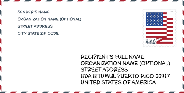
Envelope Example

This is an example of a US zip envelope. You can use a 5-digit zipcode or a detailed 9-digit zipcode to copy the mail in the following address format.
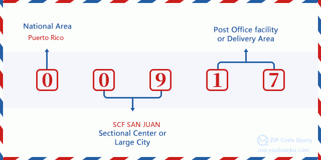
00917 Basic Meaning
What does each digit of ZIP Code 00917 stands for? The first digit designates a national area, which ranges from zero for the Northeast to nine for the far West. The 2-3 digits are the code of a sectional center facility in that region. The last two digits designate small post offices or postal zones.
Online Map

This is online map of the address Urb Umpierre, Puerto Rico, United States. You may use button to move and zoom in / out. The map information is for reference only.
University

This is the ZIP Code 00917 - University page list. Its detail university Name, Street, City, State, ZIP Code, Phone is as below.
| Name | Street | City | State | ZIP Code | Phone |
| Escuela Hotelera de San Juan | 229 Guayama St | Hato Rey | PR | 00917 | (787) 759-7599 x129 |
| Liceo de Arte y Tecnologia | 405 Ponce de Leon Ave. | San Juan | PR | 00917 | (787) 999-2473 x2356 |
School
This is the ZIP Code 00917 - School page list. Its detail School Name, Address, City, State, ZIP Code is as below.
- School Name: GUSTAVO A. BECQUER
- Address: CALLE FRANCIA ESQ ARECIBO 31
- City: SAN JUAN
- State: PR
- Grades: UG
- ZIP Code: 00917
Population for ZIP Code 00917

What is the total population in ZIP Code 00917? Below is detail information.
- Population for ZIP Code 00917: 16,537
- 2010 Population: 21,053
The 2020 demographic statistics are in progress. The current population in ZIP code 00917 is 16,537, and the population in 2010 is 21,053.
Gender

In all the statistical population, the male population is 9,874, the female population is 11,179.
- Male Population: 9,874
- Female Population: 11,179
Race

In all the statistical population, the male population is 9,874, the female population is 11,179.
- White Population: 14,734
- Black Population: 4,548
- Hispanic Population: 20,791
- Asian Population: 194
- Hawaiian Population: 19
- Indian Population: 322
- Other Population: 2,348
Age

In all the statistical population, the White population is 14,734, the Black population is 4,548, the Hispanic population is 20,791, the Asian population is 194, the Hawaiian population is 19, the Indian Ppopulation is 322 and Other population is 2,348.
- Age's Median: 42.9
- Median of male age: 40.0
- Median of female age: 45.3
Households for ZIP Code 00917
ZIP code 00917 has 9,567 households, with an average number of 2.17 persons per household. The average income per household in Zip code 00917 is 14,307 USD, and the average house value is 114,700 USD.
- Households Per Zipcode: 9,567
- Persons Per Household: 2.17
- Average House Value: 114,700
- Income Per Household: 14,307
Geographic

The latitude of the Zip code 00917 is 18.421194, the longitude is -66.049352, and the elevation is 22. It has land area of 1.297 square miles, and water area of 0.018 square miles. The time zone for ZIP code 00917 is Atlantic (GMT -04:00). Daylight saving time should be observed in the area where the zip code is located.
- Latitude: 18.421194
- Longitude: -66.049352
- Elevation: 22
- Land Area: 1.297
- Water Area: 0.018
- Time Zone: Atlantic (GMT -04:00)
- Day Light Saving: N
Delivery

In the ZIP code 00917, there are 7,621 residential delivery mailboxes and centralized units, and 888 commercial delivery mailbox and centralized units, 3,611 single family deliveries and 4,010 multifamily deliveries, and the box count is 8,509. The main post office has city delivery carrier routes for the ZIP code 00917.
- Delivery Residential: 7,621
- Delivery Business: 888
- Delivery Total: 8,509
- Single Family Delivery Units: 3,611
- Multi Family Delivery Units: 4,010
- City Delivery Indicator: Y


Add new comment