United States ZIP Code: 01085
This is the Massachusetts ZIP Code 01085 page list. Its detail State, County, City, Longitude, Latitude, Envelope Example, Population is as below.

ZIP Code 01085 Information

-
-
Country:
U.S. - United States
State:
State FIPS:
25
Area Code:
ZIP Code:
01085
ZIP Type:
S (Standard)
❓What does S (Standard) mean? A "standard" ZIP Code is what most people think of when they talk about ZIP Codes - essentially a town, city, or a division of a city that has mail service.
-


-
Iconic US Landmark Legacy Designs
Get PNG, SVG, EPS, AI, PDF Versions at Just $0.1
 Download Now
-


ZipCodeCraft
ZIP Code 01085 - City

This is the city information corresponding to 01085:
| State | County | City | City Type ?In many cases, a ZIP Code can have multiple "names", meaning cities, towns, or subdivisions, in its boundaries. However, it will ALWAYS have exactly 1 "default" name. D - Default - This is the "preferred" name - by the USPS - for a city. Each ZIP Code has one - and only one - "default" name. In most cases, this is what people who live in that area call the city as well. A - Acceptable - This name can be used for mailing purposes. Often times alternative names are large neighborhoods or sections of the city/town. In some cases a ZIP Code may have several "acceptable" names which is used to group towns under one ZIP Code. N - Not Acceptable - A "not acceptable" name is, in many cases, a nickname that residents give that location. According to the USPS, you should NOT send mail to that ZIP Code using the "not acceptable" name when mailing. | ZIP Code |
|---|---|---|---|---|
| MA | Hampden | Montgomery | A (Acceptable) | 01085 |
| MA | Hampden | Westfield | D (Default) | 01085 |
❓What does D (Default) mean? This is the "preferred" name - by the USPS - for a city. Each ZIP Code has one - and only one - "default" name. In most cases, this is what people who live in that area call the city as well.
❓What does A (Acceptable) mean? This name can be used for mailing purposes. Often times alternative names are large neighborhoods or sections of the city/town. In some cases a ZIP Code may have several "acceptable" names which is used to group towns under one ZIP Code.
ZIP Code 01085 Plus 4
ZIP Code 5 plus 4 is the extension of 5-digit zip code, It can be used to locate a more detailed location. The last four digits designate segment or one side of a street or an apartment. You can find the ZIP+4 code and corresponding address of the zip code 01085 below.
| ZIP Code 5 Plus 4 | Address |
|---|---|
| 01085-1000 | 119 MONTGOMERY RD #A , WESTFIELD, MA |
| 01085-1001 | 1 CAROLE AVE, WESTFIELD, MA |
| 01085-1002 | 2 CAROLE AVE, WESTFIELD, MA |
| 01085-1003 | 1 MASSEY ST, WESTFIELD, MA |
| 01085-1004 | 2 MASSEY ST, WESTFIELD, MA |
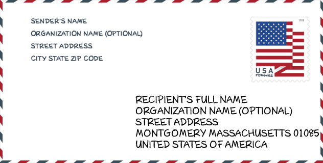
Envelope Example

This is an example of a US zip envelope. You can use a 5-digit zipcode or a detailed 9-digit zipcode to copy the mail in the following address format.
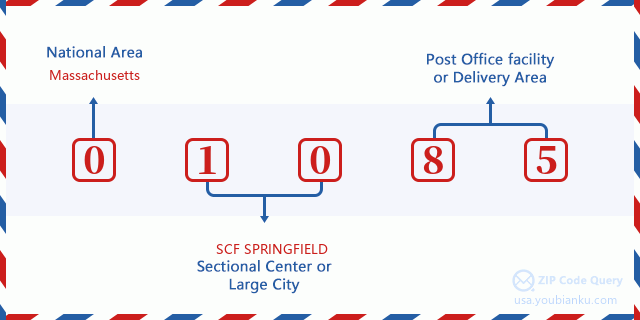
01085 Basic Meaning
What does each digit of ZIP Code 01085 stands for? The first digit designates a national area, which ranges from zero for the Northeast to nine for the far West. The 2-3 digits are the code of a sectional center facility in that region. The last two digits designate small post offices or postal zones.
Online Map

This is online map of the address Westfield, Massachusetts, United States. You may use button to move and zoom in / out. The map information is for reference only.
Hospital

This is the ZIP Code 01085 - Hospital page list. Its detail Hospital Name, Street, City, State, ZIP Code, Phone is as below.
- Name: BAYSTATE NOBLE HOSPITAL
- Address: WESTFIELD
- City: 115 WEST SILVER STREET
- State: MA
- ZIP Code: 01085
- Phone: (413) 568-2811
Library

This is the ZIP Code 01085 - Library page list. Its detail Library Name, Address, City, State, ZIP Code, Phone is as below.
| Name | Address | City | State | ZIP Code | Phone |
|---|---|---|---|---|---|
| GRACE HALL MEMORIAL LIBRARY | 161 MAIN RD. | MONTGOMERY | MA | 01085 | (413) 862-3894 |
| WESTFIELD ATHENAEUM | 6 ELM ST. | WESTFIELD | MA | 01085 | (413) 568-7833 |
School

This is the ZIP Code 01085 - School page list. Its detail School Name, Address, City, State, ZIP Code is as below.
| School Name | Address | City | State | Grades | ZIP Code |
|---|---|---|---|---|---|
| Westfield Middle School | 30 West Silver Street | Westfield | MA | UG | 01085 |
| Abner Gibbs | 50 West Silver Street | Westfield | MA | UG | 01085 |
| Franklin Ave | 22 Franklin Avenue | Westfield | MA | UG | 01085 |
| Highland | 34 Western Avenue | Westfield | MA | UG | 01085 |
| Southampton Road | 330 Southampton Rd | Westfield | MA | UG | 01085 |
| Westfield High | 177 Montgomery Rd | Westfield | MA | UG | 01085 |
| Westfield Technical Academy | 33 Smith Avenue | Westfield | MA | UG | 01085 |
| Fort Meadow Early Childhood Center | 35 White Street | Westfield | MA | UG | 01085 |
| Munger Hill | 33 Mallard Lane | Westfield | MA | UG | 01085 |
| Paper Mill | 148 Paper Mill Rd | Westfield | MA | UG | 01085 |
| Westfield Intermediate School | 350 Southampton Road | Westfield | MA | UG | 01085 |
| Westfield Virtual School | 18 Broad Street | Westfield | MA | UG | 01085 |
Population for ZIP Code 01085

What is the total population in ZIP Code 01085? Below is detail information.
- Population for ZIP Code 01085: 40,753
- 2010 Population: 41,117
The 2020 demographic statistics are in progress. The current population in ZIP code 01085 is 40,753, and the population in 2010 is 41,117.
Gender

In all the statistical population, the male population is 20,111, the female population is 21,006.
- Male Population: 20,111
- Female Population: 21,006
Race

In all the statistical population, the male population is 20,111, the female population is 21,006.
- White Population: 38,865
- Black Population: 953
- Hispanic Population: 3,075
- Asian Population: 688
- Hawaiian Population: 51
- Indian Population: 327
- Other Population: 1,092
Age

In all the statistical population, the White population is 38,865, the Black population is 953, the Hispanic population is 3,075, the Asian population is 688, the Hawaiian population is 51, the Indian Ppopulation is 327 and Other population is 1,092.
- Age's Median: 39.1
- Median of male age: 37.6
- Median of female age: 40.4
Households for ZIP Code 01085
ZIP code 01085 has 15,613 households, with an average number of 2.49 persons per household. The average income per household in Zip code 01085 is 64,026 USD, and the average house value is 228,900 USD.
- Households Per Zipcode: 15,613
- Persons Per Household: 2.49
- Average House Value: 228,900
- Income Per Household: 64,026
Geographic

The latitude of the Zip code 01085 is 42.162725, the longitude is -72.771374, and the elevation is 316. It has land area of 59.712 square miles, and water area of 1.137 square miles. The time zone for ZIP code 01085 is Eastern (GMT -05:00). Daylight saving time should be observed in the area where the zip code is located.
- Latitude: 42.162725
- Longitude: -72.771374
- Elevation: 316
- Land Area: 59.712
- Water Area: 1.137
- Time Zone: Eastern (GMT -05:00)
- Region: Northeast
- Division: New England
- Day Light Saving: Y
Congressional District

The Congressional District for ZIP code 01085 is Massachusetts's 1st congressional district, the Congressional Land Area is 2350.29 square mile.
- Congressional District: 1st
- Congressional Land Area: 2350.29
Delivery

In the ZIP code 01085, there are 16,367 residential delivery mailboxes and centralized units, and 1,032 commercial delivery mailbox and centralized units, 13,148 single family deliveries and 2,033 multifamily deliveries, and the box count is 17,272. The main post office has city delivery carrier routes for the ZIP code 01085.
- Delivery Residential: 16,367
- Delivery Business: 1,032
- Delivery Total: 17,272
- Single Family Delivery Units: 13,148
- Multi Family Delivery Units: 2,033
- City Delivery Indicator: Y
Business

In ZIP code 01085, the number of business is 848, the number of employee is 13,884, the business first quarter payroll is 151,698,000 USD, the business annual payroll is 636,434,000 USD.
- Number Of Businesses: 848
- Number Of Employees: 13,884
- Business First Quarter Payroll: 151,698,000
- Business Annual Payroll: 636,434,000


Add new comment