ZIP Code: 02062, Norwood, MA
ZIP Code 02062 is located in Norwood, Massachusetts. Its detail State, County, City, Longitude, Latitude, Envelope Example, Population is as below.
ZIP Code 02062 Information

-
-
Country:
U.S. - United States
State:
County FIPS:
25021
County:
City:
Area Code:
City Type ?In many cases, a ZIP Code can have multiple "names", meaning cities, towns, or subdivisions, in its boundaries. However, it will ALWAYS have exactly 1 "default" name. D - Default - This is the "preferred" name - by the USPS - for a city. Each ZIP Code has one - and only one - "default" name. In most cases, this is what people who live in that area call the city as well. A - Acceptable - This name can be used for mailing purposes. Often times alternative names are large neighborhoods or sections of the city/town. In some cases a ZIP Code may have several "acceptable" names which is used to group towns under one ZIP Code. N - Not Acceptable - A "not acceptable" name is, in many cases, a nickname that residents give that location. According to the USPS, you should NOT send mail to that ZIP Code using the "not acceptable" name when mailing.:
D (Default)
ZIP Code:
02062
❓What does D (Default) mean? This is the "preferred" name - by the USPS - for a city. Each ZIP Code has one - and only one - "default" name. In most cases, this is what people who live in that area call the city as well.
-


-
Iconic US Landmark Legacy Designs
Get PNG, SVG, EPS, AI, PDF Versions at Just $0.1
 Download Now
-


ZipCodeCraft
ZIP Code 02062 Plus 4
ZIP Code 5 plus 4 is the extension of 5-digit zip code, It can be used to locate a more detailed location. The last four digits designate segment or one side of a street or an apartment. You can find the ZIP+4 code and corresponding address of the zip code 02062 below.
| ZIP Code 5 Plus 4 | Address |
|---|---|
| 02062-0001 | PO BOX 1, NORWOOD, MA |
| 02062-0061 | PO BOX 61, NORWOOD, MA |
| 02062-0181 | PO BOX 181, NORWOOD, MA |
| 02062-0301 | PO BOX 301, NORWOOD, MA |
| 02062-0421 | PO BOX 421, NORWOOD, MA |
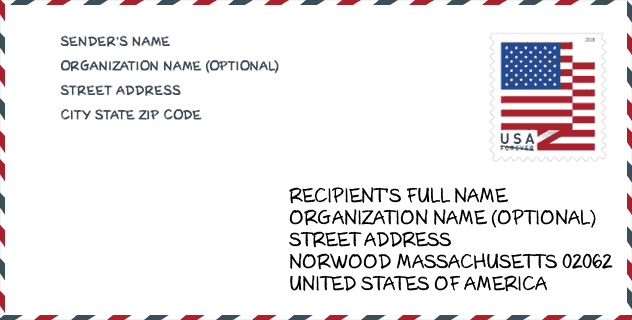
Envelope Example

This is an example of a US zip envelope. You can use a 5-digit zipcode or a detailed 9-digit zipcode to copy the mail in the following address format.
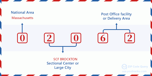
02062 Basic Meaning
What does each digit of ZIP Code 02062 stands for? The first digit designates a national area, which ranges from zero for the Northeast to nine for the far West. The 2-3 digits are the code of a sectional center facility in that region. The last two digits designate small post offices or postal zones.
Online Map

This is online map of the address Norwood, Massachusetts, United States. You may use button to move and zoom in / out. The map information is for reference only.
University

This is the ZIP Code 02062 - University page list. Its detail university Name, Street, City, State, ZIP Code, Phone is as below.
| Name | Street | City | State | ZIP Code | Phone |
| FINE Mortuary College | 150 Kerry Place | Norwood | MA | 02062 | (781) 762-1211 x22 |
| Universal Technical Institute of Massachusetts Inc | One Upland Road, Building 200 | Norwood | MA | 02062 | - |
Hospital

This is the ZIP Code 02062 - Hospital page list. Its detail Hospital Name, Street, City, State, ZIP Code, Phone is as below.
- Name: NORWOOD HOSPITAL
- Address: NORWOOD
- City: 800 WASHINGTON STREET
- State: MA
- ZIP Code: 02062
- Phone: (781) 769-4000
Library

This is the ZIP Code 02062 - Library page list. Its detail Library Name, Address, City, State, ZIP Code, Phone is as below.
- Name: MORRILL MEMORIAL LIBRARY
- Address: 33 WALPOLE ST.
- City: NORWOOD
- State: MA - Massachusetts
- ZIP Code: 02062
- Phone: (781) 769-0200
School
This is the ZIP Code 02062 - School page list. Its detail School Name, Address, City, State, ZIP Code is as below.
| School Name | Address | City | State | Grades | ZIP Code |
|---|---|---|---|---|---|
| Balch | 1170 Washington Street | Norwood | MA | UG | 02062 |
| Charles J Prescott | 66 Richland Road | Norwood | MA | UG | 02062 |
| Cornelius M Callahan | 116 Garfield Avenue | Norwood | MA | UG | 02062 |
| F A Cleveland | 33 George Willett Parkway | Norwood | MA | UG | 02062 |
| John P Oldham | 165 Prospect Street | Norwood | MA | UG | 02062 |
| Norwood High | 245 Nichols Street | Norwood | MA | UG | 02062 |
| Dr. Philip O. Coakley Middle School | 1315 Washington Street | Norwood | MA | UG | 02062 |
| George F. Willett | 100 Westover Parkway | Norwood | MA | UG | 02062 |
Population for ZIP Code 02062

What is the total population in ZIP Code 02062? Below is detail information.
- Population for ZIP Code 02062: 30,738
- 2010 Population: 28,602
The 2020 demographic statistics are in progress. The current population in ZIP code 02062 is 30,738, and the population in 2010 is 28,602.
Gender

In all the statistical population, the male population is 13,693, the female population is 14,909.
- Male Population: 13,693
- Female Population: 14,909
Race

In all the statistical population, the male population is 13,693, the female population is 14,909.
- White Population: 24,759
- Black Population: 1,666
- Hispanic Population: 1,227
- Asian Population: 1,879
- Hawaiian Population: 34
- Indian Population: 133
- Other Population: 686
Age

In all the statistical population, the White population is 24,759, the Black population is 1,666, the Hispanic population is 1,227, the Asian population is 1,879, the Hawaiian population is 34, the Indian Ppopulation is 133 and Other population is 686.
- Age's Median: 41.1
- Median of male age: 39.0
- Median of female age: 43.3
Households for ZIP Code 02062
ZIP code 02062 has 11,917 households, with an average number of 2.37 persons per household. The average income per household in Zip code 02062 is 90,511 USD, and the average house value is 420,300 USD.
- Households Per Zipcode: 11,917
- Persons Per Household: 2.37
- Average House Value: 420,300
- Income Per Household: 90,511
Geographic

The latitude of the Zip code 02062 is 42.181894, the longitude is -71.196680, and the elevation is 55. It has land area of 10.358 square miles, and water area of 0.164 square miles. The time zone for ZIP code 02062 is Eastern (GMT -05:00). Daylight saving time should be observed in the area where the zip code is located.
- Latitude: 42.181894
- Longitude: -71.196680
- Elevation: 55
- Land Area: 10.358
- Water Area: 0.164
- Time Zone: Eastern (GMT -05:00)
- Region: Northeast
- Division: New England
- Day Light Saving: Y
Congressional District

The Congressional District for ZIP code 02062 is Massachusetts's 08th congressional district, the Congressional Land Area is 326.37 square mile.
- Congressional District: 08th
- Congressional Land Area: 326.37
Delivery

In the ZIP code 02062, there are 12,970 residential delivery mailboxes and centralized units, and 1,435 commercial delivery mailbox and centralized units, 9,121 single family deliveries and 3,127 multifamily deliveries, and the box count is 14,851. The main post office has city delivery carrier routes for the ZIP code 02062.
- Delivery Residential: 12,970
- Delivery Business: 1,435
- Delivery Total: 14,851
- Single Family Delivery Units: 9,121
- Multi Family Delivery Units: 3,127
- City Delivery Indicator: Y
Business

In ZIP code 02062, the number of business is 1,241, the number of employee is 25,944, the business first quarter payroll is 441,898,000 USD, the business annual payroll is 1,757,478,000 USD.
- Number Of Businesses: 1,241
- Number Of Employees: 25,944
- Business First Quarter Payroll: 441,898,000
- Business Annual Payroll: 1,757,478,000


Add new comment