United States ZIP Code: 08012
This is the New Jersey ZIP Code 08012 page list. Its detail State, County, City, Longitude, Latitude, Envelope Example, Population is as below.

ZIP Code 08012 Information

-
-
Country:
U.S. - United States
State:
State FIPS:
34
Area Code:
ZIP Code:
08012
ZIP Type:
S (Standard)
❓What does S (Standard) mean? A "standard" ZIP Code is what most people think of when they talk about ZIP Codes - essentially a town, city, or a division of a city that has mail service.
-


-
Iconic US Landmark Legacy Designs
Get PNG, SVG, EPS, AI, PDF Versions at Just $0.1
 Download Now
-


ZipCodeCraft
ZIP Code 08012 - City

This is the city information corresponding to 08012:
| State | County | City | City Type ?In many cases, a ZIP Code can have multiple "names", meaning cities, towns, or subdivisions, in its boundaries. However, it will ALWAYS have exactly 1 "default" name. D - Default - This is the "preferred" name - by the USPS - for a city. Each ZIP Code has one - and only one - "default" name. In most cases, this is what people who live in that area call the city as well. A - Acceptable - This name can be used for mailing purposes. Often times alternative names are large neighborhoods or sections of the city/town. In some cases a ZIP Code may have several "acceptable" names which is used to group towns under one ZIP Code. N - Not Acceptable - A "not acceptable" name is, in many cases, a nickname that residents give that location. According to the USPS, you should NOT send mail to that ZIP Code using the "not acceptable" name when mailing. | ZIP Code |
|---|---|---|---|---|
| NJ | Camden | Blackwood | D (Default) | 08012 |
| NJ | Camden | Blenheim | N (Not Acceptable) | 08012 |
| NJ | Camden | Chews Landing | N (Not Acceptable) | 08012 |
| NJ | Camden | Hilltop | N (Not Acceptable) | 08012 |
| NJ | Camden | Lakeland | N (Not Acceptable) | 08012 |
| NJ | Camden | Turnersville | A (Acceptable) | 08012 |
❓What does D (Default) mean? This is the "preferred" name - by the USPS - for a city. Each ZIP Code has one - and only one - "default" name. In most cases, this is what people who live in that area call the city as well.
❓What does A (Acceptable) mean? This name can be used for mailing purposes. Often times alternative names are large neighborhoods or sections of the city/town. In some cases a ZIP Code may have several "acceptable" names which is used to group towns under one ZIP Code.
❓What does N (Not Acceptable) mean? A "not acceptable" name is, in many cases, a nickname that residents give that location. According to the USPS, you should NOT send mail to that ZIP Code using the "not acceptable" name when mailing.
ZIP Code 08012 Plus 4
ZIP Code 5 plus 4 is the extension of 5-digit zip code, It can be used to locate a more detailed location. The last four digits designate segment or one side of a street or an apartment. You can find the ZIP+4 code and corresponding address of the zip code 08012 below.
| ZIP Code 5 Plus 4 | Address |
|---|---|
| 08012-0001 | PO BOX 1, BLACKWOOD, NJ |
| 08012-0008 | PO BOX 8, BLACKWOOD, NJ |
| 08012-0009 | PO BOX 9, BLACKWOOD, NJ |
| 08012-0061 | PO BOX 61, BLACKWOOD, NJ |
| 08012-0121 | PO BOX 121, BLACKWOOD, NJ |
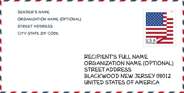
Envelope Example

This is an example of a US zip envelope. You can use a 5-digit zipcode or a detailed 9-digit zipcode to copy the mail in the following address format.
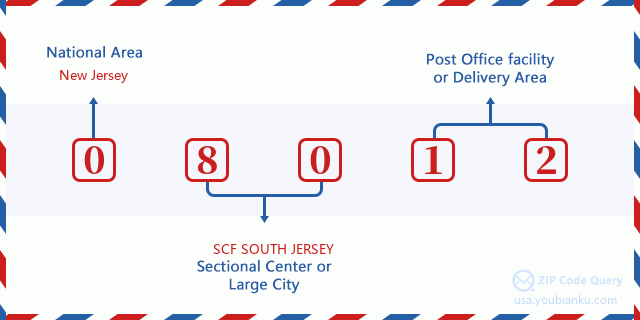
08012 Basic Meaning
What does each digit of ZIP Code 08012 stands for? The first digit designates a national area, which ranges from zero for the Northeast to nine for the far West. The 2-3 digits are the code of a sectional center facility in that region. The last two digits designate small post offices or postal zones.
Online Map

This is online map of the address Turnersville, New Jersey, United States. You may use button to move and zoom in / out. The map information is for reference only.
University

This is the ZIP Code 08012 - University page list. Its detail university Name, Street, City, State, ZIP Code, Phone is as below.
| Name | Street | City | State | ZIP Code | Phone |
| Camden County College | 200 College Drive | Blackwood | NJ | 08012 | (856) 227-7200 |
| Pennco Tech-Blackwood | 99 Erial Road | Blackwood | NJ | 08012 | (856) 232-0310 |
Hospital

This is the ZIP Code 08012 - Hospital page list. Its detail Hospital Name, Street, City, State, ZIP Code, Phone is as below.
- Name: NORTHBROOK BEHAVIORAL HEALTH HOSPITAL
- Address: BLACKWOOD
- City: 425 WOODBURY TURNERSVILLE ROAD
- State: NJ
- ZIP Code: 08012
- Phone: (856) 374-6500
Museum

This is the ZIP Code 08012 - Museum page list. Its detail Museum Name, Street, City, State, ZIP Code, Phone is as below.
| Name | Street | City | State | ZIP Code | Phone |
| TUN TAVERN HISTORICAL SOCIETY | 42 COLES RD | BLENHEIM | NJ | 08012 | |
| BLACKWOOD ART GALLERY | 200 COLLEGE DRIVE | CAMDEN | NJ | 08012 | (856) 227-7200 |
| MARLIN GALLERY | 200 COLLEGE DRIVE | CAMDEN | NJ | 08012 | (856) 227-7200 |
Library

This is the ZIP Code 08012 - Library page list. Its detail Library Name, Address, City, State, ZIP Code, Phone is as below.
- Name: GLOUCESTER TOWNSHIP BRANCH LIBRARY
- Address: 1650 BLACKWOOD-CLEMENTON RD.
- City: BLACKWOOD
- State: NJ - New Jersey
- ZIP Code: 08012
- Phone: (609) 228-0022
School
This is the ZIP Code 08012 - School page list. Its detail School Name, Address, City, State, ZIP Code is as below.
| School Name | Address | City | State | Grades | ZIP Code |
|---|---|---|---|---|---|
| CAMDEN CO JDC | WOODBURY TURNERSVILLE RD LAKE | BLACKWOODLEX | NJ | UG | 08012 |
| Highland Regional High School | 450 Erial Road | BLACKWOOD | NJ | UG | 08012 |
| Blackwood Elementary School | 260 BLENHEIM ERIAL RD | BLACKWOOD | NJ | UG | 08012 |
| Charles W. Lewis Middle School | 875 ERIAL ROAD | BLACKWOOD | NJ | UG | 08012 |
| Chews Elementary School | 600 CHEWSLANDING SOMERDALE RD | BLACKWOOD | NJ | UG | 08012 |
| Glen Landing Middle School | 85 LITTLE GLOUCESTER ROAD | BLACKWOOD | NJ | UG | 08012 |
| Bells Elementary School | 227 GREENTREE RD | TURNERSVILLE | NJ | UG | 08012 |
Population for ZIP Code 08012

What is the total population in ZIP Code 08012? Below is detail information.
- Population for ZIP Code 08012: 39,689
- 2010 Population: 38,992
The 2020 demographic statistics are in progress. The current population in ZIP code 08012 is 39,689, and the population in 2010 is 38,992.
Gender

In all the statistical population, the male population is 18,810, the female population is 20,182.
- Male Population: 18,810
- Female Population: 20,182
Race

In all the statistical population, the male population is 18,810, the female population is 20,182.
- White Population: 32,784
- Black Population: 4,471
- Hispanic Population: 2,192
- Asian Population: 1,499
- Hawaiian Population: 40
- Indian Population: 224
- Other Population: 838
Age

In all the statistical population, the White population is 32,784, the Black population is 4,471, the Hispanic population is 2,192, the Asian population is 1,499, the Hawaiian population is 40, the Indian Ppopulation is 224 and Other population is 838.
- Age's Median: 38.9
- Median of male age: 37.4
- Median of female age: 40.1
Households for ZIP Code 08012
ZIP code 08012 has 14,921 households, with an average number of 2.59 persons per household. The average income per household in Zip code 08012 is 72,597 USD, and the average house value is 204,300 USD.
- Households Per Zipcode: 14,921
- Persons Per Household: 2.59
- Average House Value: 204,300
- Income Per Household: 72,597
Geographic

The latitude of the Zip code 08012 is 39.785363, the longitude is -75.050033, and the elevation is 87. It has land area of 14.89 square miles, and water area of 0.26 square miles. The time zone for ZIP code 08012 is Eastern (GMT -05:00). Daylight saving time should be observed in the area where the zip code is located.
- Latitude: 39.785363
- Longitude: -75.050033
- Elevation: 87
- Land Area: 14.89
- Water Area: 0.26
- Time Zone: Eastern (GMT -05:00)
- Region: Northeast
- Division: Middle Atlantic
- Day Light Saving: Y
Congressional District

The Congressional District for ZIP code 08012 is New Jersey's 1st congressional district, the Congressional Land Area is 350.02 square mile.
- Congressional District: 1st
- Congressional Land Area: 350.02
Delivery

In the ZIP code 08012, there are 15,324 residential delivery mailboxes and centralized units, and 1,076 commercial delivery mailbox and centralized units, 10,705 single family deliveries and 391 multifamily deliveries, and the box count is 17,070. The main post office has city delivery carrier routes for the ZIP code 08012.
- Delivery Residential: 15,324
- Delivery Business: 1,076
- Delivery Total: 17,070
- Single Family Delivery Units: 10,705
- Multi Family Delivery Units: 391
- City Delivery Indicator: Y
Business

In ZIP code 08012, the number of business is 916, the number of employee is 14,004, the business first quarter payroll is 130,939,000 USD, the business annual payroll is 558,135,000 USD.
- Number Of Businesses: 916
- Number Of Employees: 14,004
- Business First Quarter Payroll: 130,939,000
- Business Annual Payroll: 558,135,000


Add new comment