United States ZIP Code: 10467
This is the New York ZIP Code 10467 page list. Its detail State, County, City, Longitude, Latitude, Envelope Example, Population is as below.

ZIP Code 10467 Information

-
-
Country:
U.S. - United States
State:
State FIPS:
36
ZIP Code:
10467
ZIP Type:
S (Standard)
❓What does S (Standard) mean? A "standard" ZIP Code is what most people think of when they talk about ZIP Codes - essentially a town, city, or a division of a city that has mail service.
-


-
Iconic US Landmark Legacy Designs
Get PNG, SVG, EPS, AI, PDF Versions at Just $0.1
 Download Now
-


ZipCodeCraft
ZIP Code 10467 - City

This is the city information corresponding to 10467:
| State | County | City | City Type ?In many cases, a ZIP Code can have multiple "names", meaning cities, towns, or subdivisions, in its boundaries. However, it will ALWAYS have exactly 1 "default" name. D - Default - This is the "preferred" name - by the USPS - for a city. Each ZIP Code has one - and only one - "default" name. In most cases, this is what people who live in that area call the city as well. A - Acceptable - This name can be used for mailing purposes. Often times alternative names are large neighborhoods or sections of the city/town. In some cases a ZIP Code may have several "acceptable" names which is used to group towns under one ZIP Code. N - Not Acceptable - A "not acceptable" name is, in many cases, a nickname that residents give that location. According to the USPS, you should NOT send mail to that ZIP Code using the "not acceptable" name when mailing. | ZIP Code |
|---|---|---|---|---|
| NY | Bronx | Allerton | N (Not Acceptable) | 10467 |
| NY | Bronx | Bronx | D (Default) | 10467 |
| NY | Bronx | Mosholu | N (Not Acceptable) | 10467 |
| NY | Bronx | Van Cott | N (Not Acceptable) | 10467 |
| NY | Bronx | Williamsbridge | N (Not Acceptable) | 10467 |
❓What does D (Default) mean? This is the "preferred" name - by the USPS - for a city. Each ZIP Code has one - and only one - "default" name. In most cases, this is what people who live in that area call the city as well.
❓What does N (Not Acceptable) mean? A "not acceptable" name is, in many cases, a nickname that residents give that location. According to the USPS, you should NOT send mail to that ZIP Code using the "not acceptable" name when mailing.
ZIP Code 10467 Plus 4
ZIP Code 5 plus 4 is the extension of 5-digit zip code, It can be used to locate a more detailed location. The last four digits designate segment or one side of a street or an apartment. You can find the ZIP+4 code and corresponding address of the zip code 10467 below.
| ZIP Code 5 Plus 4 | Address |
|---|---|
| 10467-0001 | PO BOX 1, BRONX, NY |
| 10467-0061 | PO BOX 61, BRONX, NY |
| 10467-0121 | PO BOX 121, BRONX, NY |
| 10467-0181 | PO BOX 181, BRONX, NY |
| 10467-0241 | PO BOX 241, BRONX, NY |
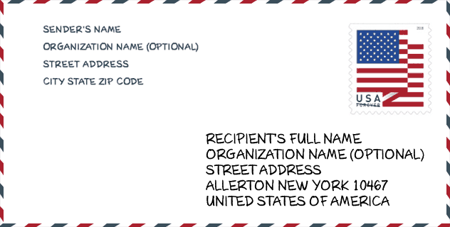
Envelope Example

This is an example of a US zip envelope. You can use a 5-digit zipcode or a detailed 9-digit zipcode to copy the mail in the following address format.
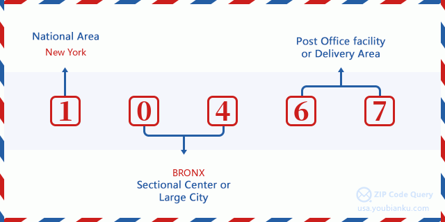
10467 Basic Meaning
What does each digit of ZIP Code 10467 stands for? The first digit designates a national area, which ranges from zero for the Northeast to nine for the far West. The 2-3 digits are the code of a sectional center facility in that region. The last two digits designate small post offices or postal zones.
Online Map

This is online map of the address Williamsbridge, New York, United States. You may use button to move and zoom in / out. The map information is for reference only.
Hospital

This is the ZIP Code 10467 - Hospital page list. Its detail Hospital Name, Street, City, State, ZIP Code, Phone is as below.
| Name | Address | City | State | ZIP Code | Phone |
|---|---|---|---|---|---|
| MONTEFIORE MEDICAL CENTER | 111 EAST 210TH STREET | BRONX | NY | 10467 | (718) 920-4321 |
| NORTH CENTRAL BRONX HOSPITAL | 3424 KOSSUTH AVENUE & 210TH STREET | BRONX | NY | 10467 | (212) 519-5000 |
Museum

This is the ZIP Code 10467 - Museum page list. Its detail Museum Name, Street, City, State, ZIP Code, Phone is as below.
- Name: VALENTINE-VARIAN HOUSE
- Street: 3266 BAINBRIDGE AVE
- City: BRONX
- State: NY
- ZIP Code: 10467
- Phone: (718) 881-8900
Library

This is the ZIP Code 10467 - Library page list. Its detail Library Name, Address, City, State, ZIP Code, Phone is as below.
| Name | Address | City | State | ZIP Code | Phone |
|---|---|---|---|---|---|
| ALLERTON BRANCH | 2740 BARNES AVENUE | BRONX | NY | 10467 | (718) 881-4240 |
| MOSHOLU BRANCH | 285 EAST 205TH STREET | BRONX | NY | 10467 | (718) 882-8239 |
School

This is the ZIP Code 10467 - School page list. Its detail School Name, Address, City, State, ZIP Code is as below.
| School Name | Address | City | State | Grades | ZIP Code |
|---|---|---|---|---|---|
| PS 56 NORWOOD HEIGHTS | 341 E 207TH ST | BRONX | NY | UG | 10467 |
| PS/MS 280 MOSHOLU PARKWAY | 3202 STEUBEN AVE | BRONX | NY | UG | 10467 |
| BRONX DANCE ACADEMY SCHOOL | 3617 BAINBRIDGE AVE | BRONX | NY | UG | 10467 |
| BEDFORD PARK ELEMENTARY SCHOOL | 3177 WEBSTER AVE | BRONX | NY | UG | 10467 |
| PS 96 RICHARD RODGERS | 2385 OLINVILLE AVE | BRONX | NY | UG | 10467 |
| HIGH SCHOOL FOR CONTEMPORARY ARTS | 800 E GUN HILL RD | BRONX | NY | UG | 10467 |
| BRONX AEROSPACE HIGH SCHOOL | 800 E GUN HILL RD | BRONX | NY | UG | 10467 |
| BRONX HIGH SCHOOL FOR WRITING AND COMMUNICATION ARTS | 800 E GUN HILL RD | BRONX | NY | UG | 10467 |
| BRONX LAB SCHOOL | 800 E GUN HILL RD | BRONX | NY | UG | 10467 |
| HIGH SCHOOL OF COMPUTERS AND TECHNOLOGY | 800 E GUN HILL RD | BRONX | NY | UG | 10467 |
| BRONX ACADEMY OF HEALTH CAREERS | 800 E GUN HILL RD | BRONX | NY | UG | 10467 |
| NORTH BRONX SCHOOL OF EMPOWERMENT | 3710 BARNES AVE | BRONX | NY | UG | 10467 |
| BRONX GREEN MIDDLE SCHOOL | 2441 WALLACE AVE | BRONX | NY | UG | 10467 |
| LEADERS OF TOMORROW | 3710 BARNES AVE | BRONX | NY | UG | 10467 |
| PELHAM ACADEMY OF ACADEMICS AND COMMUNITY ENGAGEMENT | 2441 WALLACE AVE | BRONX | NY | UG | 10467 |
| BRONX PARK MIDDLE SCHOOL | 2441 WALLACE AVE | BRONX | NY | UG | 10467 |
| PS 168 | 3050 WEBSTER AVE | BRONX | NY | UG | 10467 |
| PS 469-BRONX SCHOOL FOR CONTINUOUS LEARNING (THE) | 3177 WEBSTER AVE | BRONX | NY | UG | 10467 |
| BRONX COMMUNITY CHARTER SCHOOL | 3170 WEBSTER AVE | BRONX | NY | UG | 10467 |
Population for ZIP Code 10467

What is the total population in ZIP Code 10467? Below is detail information.
- Population for ZIP Code 10467: 96,324
- 2010 Population: 97,060
The 2020 demographic statistics are in progress. The current population in ZIP code 10467 is 96,324, and the population in 2010 is 97,060.
Gender

In all the statistical population, the male population is 45,318, the female population is 51,742.
- Male Population: 45,318
- Female Population: 51,742
Race

In all the statistical population, the male population is 45,318, the female population is 51,742.
- White Population: 28,615
- Black Population: 40,260
- Hispanic Population: 46,661
- Asian Population: 7,032
- Hawaiian Population: 440
- Indian Population: 2,043
- Other Population: 23,955
Age

In all the statistical population, the White population is 28,615, the Black population is 40,260, the Hispanic population is 46,661, the Asian population is 7,032, the Hawaiian population is 440, the Indian Ppopulation is 2,043 and Other population is 23,955.
- Age's Median: 32.8
- Median of male age: 31.1
- Median of female age: 34.2
Households for ZIP Code 10467
ZIP code 10467 has 35,524 households, with an average number of 2.68 persons per household. The average income per household in Zip code 10467 is 37,015 USD, and the average house value is 335,400 USD.
- Households Per Zipcode: 35,524
- Persons Per Household: 2.68
- Average House Value: 335,400
- Income Per Household: 37,015
Geographic

The latitude of the Zip code 10467 is 40.876653, the longitude is -73.871508, and the elevation is 72. It has land area of 2.336 square miles, and water area of 0 square miles. The time zone for ZIP code 10467 is Eastern (GMT -05:00). Daylight saving time should be observed in the area where the zip code is located.
- Latitude: 40.876653
- Longitude: -73.871508
- Elevation: 72
- Land Area: 2.336
- Water Area: 0
- Time Zone: Eastern (GMT -05:00)
- Region: Northeast
- Division: Middle Atlantic
- Day Light Saving: Y
Congressional District

The Congressional District for ZIP code 10467 is New York's 13th|14th|16th congressional district, the Congressional Land Area is 10.25|28.29|78.37 square mile.
- Congressional District: 13th|14th|16th
- Congressional Land Area: 10.25|28.29|78.37
Delivery

In the ZIP code 10467, there are 35,942 residential delivery mailboxes and centralized units, and 1,458 commercial delivery mailbox and centralized units, 3,628 single family deliveries and 31,554 multifamily deliveries, and the box count is 39,808. The main post office has city delivery carrier routes for the ZIP code 10467.
- Delivery Residential: 35,942
- Delivery Business: 1,458
- Delivery Total: 39,808
- Single Family Delivery Units: 3,628
- Multi Family Delivery Units: 31,554
- City Delivery Indicator: Y
Business

In ZIP code 10467, the number of business is 1,136, the number of employee is 29,624, the business first quarter payroll is 516,028,000 USD, the business annual payroll is 2,129,604,000 USD.
- Number Of Businesses: 1,136
- Number Of Employees: 29,624
- Business First Quarter Payroll: 516,028,000
- Business Annual Payroll: 2,129,604,000
Social Security Benefits

There are 13,230 beneficiaries with benefits in current-payment status for ZIP code 10467, of which 7,990 are retired workers, 2,825 are disabled workers, 680 are widow(er)s and parents, 490 are spouses and 1,245 are children. The number of beneficiaries aged 65 or older is 8,760. The total monthly benefits are 14,827,000 USD, of which 9,890,000 USD for retired workers, 732,000 USD for widow(er)s and parents.
- Total Number: 13,230
- Retired workers Number: 7,990
- Disabled workers Number: 2,825
- Widow(er)s and parents Number: 680
- Spouses Number: 490
- Children Number: 1,245
- All beneficiaries per month: 14,827,000
- Retired workers per month: 9,890,000
- Widow(er)s and parents per month: 732,000
- Number of beneficiaries aged 65 or older: 8,760


Add new comment