United States ZIP Code: 29418
This is the South Carolina ZIP Code 29418 page list. Its detail State, County, City, Longitude, Latitude, Envelope Example, Population is as below.

ZIP Code 29418 Information

-
-
Country:
U.S. - United States
State:
State FIPS:
45
Area Code:
ZIP Code:
29418
ZIP Type:
S (Standard)
❓What does S (Standard) mean? A "standard" ZIP Code is what most people think of when they talk about ZIP Codes - essentially a town, city, or a division of a city that has mail service.
-


-
Iconic US Landmark Legacy Designs
Get PNG, SVG, EPS, AI, PDF Versions at Just $0.1
 Download Now
-


ZipCodeCraft
ZIP Code 29418 - City

This is the city information corresponding to 29418:
| State | County | City | City Type ?In many cases, a ZIP Code can have multiple "names", meaning cities, towns, or subdivisions, in its boundaries. However, it will ALWAYS have exactly 1 "default" name. D - Default - This is the "preferred" name - by the USPS - for a city. Each ZIP Code has one - and only one - "default" name. In most cases, this is what people who live in that area call the city as well. A - Acceptable - This name can be used for mailing purposes. Often times alternative names are large neighborhoods or sections of the city/town. In some cases a ZIP Code may have several "acceptable" names which is used to group towns under one ZIP Code. N - Not Acceptable - A "not acceptable" name is, in many cases, a nickname that residents give that location. According to the USPS, you should NOT send mail to that ZIP Code using the "not acceptable" name when mailing. | ZIP Code |
|---|---|---|---|---|
| SC | Charleston | Ch Hgts | N (Not Acceptable) | 29418 |
| SC | Charleston | Charleston | A (Acceptable) | 29418 |
| SC | Charleston | Charleston Heights | N (Not Acceptable) | 29418 |
| SC | Charleston | Charleston Hts | N (Not Acceptable) | 29418 |
| SC | Charleston | Chas | N (Not Acceptable) | 29418 |
| SC | Charleston | Chas Hgts | N (Not Acceptable) | 29418 |
| SC | Charleston | N Charleston | A (Acceptable) | 29418 |
| SC | Charleston | No Chas | N (Not Acceptable) | 29418 |
| SC | Charleston | North Charleston | D (Default) | 29418 |
❓What does D (Default) mean? This is the "preferred" name - by the USPS - for a city. Each ZIP Code has one - and only one - "default" name. In most cases, this is what people who live in that area call the city as well.
❓What does A (Acceptable) mean? This name can be used for mailing purposes. Often times alternative names are large neighborhoods or sections of the city/town. In some cases a ZIP Code may have several "acceptable" names which is used to group towns under one ZIP Code.
❓What does N (Not Acceptable) mean? A "not acceptable" name is, in many cases, a nickname that residents give that location. According to the USPS, you should NOT send mail to that ZIP Code using the "not acceptable" name when mailing.
ZIP Code 29418 Plus 4
ZIP Code 5 plus 4 is the extension of 5-digit zip code, It can be used to locate a more detailed location. The last four digits designate segment or one side of a street or an apartment. You can find the ZIP+4 code and corresponding address of the zip code 29418 below.
| ZIP Code 5 Plus 4 | Address |
|---|---|
| 29418-0005 | 4840 TANGER OUTLET BLVD #00000501 , NORTH CHARLESTON, SC |
| 29418-1900 | 109 IRONWOOD TRL #A , NORTH CHARLESTON, SC |
| 29418-1901 | 107 IRONWOOD TRL #A , NORTH CHARLESTON, SC |
| 29418-1902 | 107 IRONWOOD TRL #H , NORTH CHARLESTON, SC |
| 29418-1903 | 102 IRONWOOD TRL #A , NORTH CHARLESTON, SC |
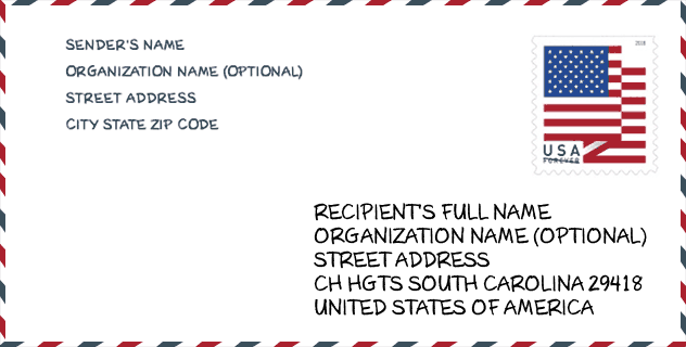
Envelope Example

This is an example of a US zip envelope. You can use a 5-digit zipcode or a detailed 9-digit zipcode to copy the mail in the following address format.
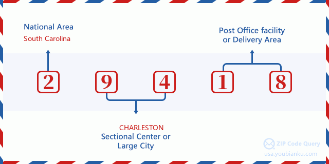
29418 Basic Meaning
What does each digit of ZIP Code 29418 stands for? The first digit designates a national area, which ranges from zero for the Northeast to nine for the far West. The 2-3 digits are the code of a sectional center facility in that region. The last two digits designate small post offices or postal zones.
Online Map

This is online map of the address North Charleston, South Carolina, United States. You may use button to move and zoom in / out. The map information is for reference only.
University

This is the ZIP Code 29418 - University page list. Its detail university Name, Street, City, State, ZIP Code, Phone is as below.
| Name | Street | City | State | ZIP Code | Phone |
| Miller-Motte Technical College-Charleston | 8085 Rivers Ave., Ste E | Charleston | SC | 29418 | - |
| Platt College-Miller-Motte Technical-Charleston | 8085 Rivers Ave., Ste E | Charleston | SC | 29418 | (843) 574-0101 |
| Strayer University-Charleston Campus | 5010 Wetland Crossing | North Charleston | SC | 29418 | (877) 455-7180 |
| Miller-Motte College-Charleston | 8085 Rivers Ave., Ste E | Charleston | SC | 29418 | (843) 574-0101 |
Museum

This is the ZIP Code 29418 - Museum page list. Its detail Museum Name, Street, City, State, ZIP Code, Phone is as below.
- Name: NORTH CHARLESTON FIRE MUSEUM
- Street: 4975 CENTRE POINTE DR
- City: NORTH CHARLESTON
- State: SC
- ZIP Code: 29418
- Phone: (843) 740-5550
Library

This is the ZIP Code 29418 - Library page list. Its detail Library Name, Address, City, State, ZIP Code, Phone is as below.
- Name: DORCHESTER ROAD REGIONAL LIBRARY
- Address: 6325 DORCHESTER ROAD
- City: N. CHARLESTON
- State: SC - South Carolina
- ZIP Code: 29418
- Phone: (803) 552-6466
School
This is the ZIP Code 29418 - School page list. Its detail School Name, Address, City, State, ZIP Code is as below.
| School Name | Address | City | State | Grades | ZIP Code |
|---|---|---|---|---|---|
| W. B. Goodwin Elementary | 5501 Dorchester Road | North Charleston | SC | UG | 29418 |
| RB Stall High | 3625 Ashley Phosphate Road | North Charleston | SC | UG | 29418 |
| Jerry Zucker Middle School of Science | 6401 Dorchester Road | North Charleston | SC | UG | 29418 |
| Palmetto Scholars Academy | 7499 Dorchester Road | North Charleston | SC | UG | 29418 |
Population for ZIP Code 29418

What is the total population in ZIP Code 29418? Below is detail information.
- Population for ZIP Code 29418: 25,738
- 2010 Population: 23,540
The 2020 demographic statistics are in progress. The current population in ZIP code 29418 is 25,738, and the population in 2010 is 23,540.
Gender

In all the statistical population, the male population is 11,396, the female population is 12,144.
- Male Population: 11,396
- Female Population: 12,144
Race

In all the statistical population, the male population is 11,396, the female population is 12,144.
- White Population: 9,936
- Black Population: 11,482
- Hispanic Population: 2,627
- Asian Population: 608
- Hawaiian Population: 59
- Indian Population: 212
- Other Population: 1,859
Age

In all the statistical population, the White population is 9,936, the Black population is 11,482, the Hispanic population is 2,627, the Asian population is 608, the Hawaiian population is 59, the Indian Ppopulation is 212 and Other population is 1,859.
- Age's Median: 32.7
- Median of male age: 31.9
- Median of female age: 33.7
Households for ZIP Code 29418
ZIP code 29418 has 9,544 households, with an average number of 2.46 persons per household. The average income per household in Zip code 29418 is 39,577 USD, and the average house value is 150,500 USD.
- Households Per Zipcode: 9,544
- Persons Per Household: 2.46
- Average House Value: 150,500
- Income Per Household: 39,577
Geographic

The latitude of the Zip code 29418 is 32.890078, the longitude is -80.058944, and the elevation is 29. It has land area of 13.486 square miles, and water area of 0.378 square miles. The time zone for ZIP code 29418 is Eastern (GMT -05:00). Daylight saving time should be observed in the area where the zip code is located.
- Latitude: 32.890078
- Longitude: -80.058944
- Elevation: 29
- Land Area: 13.486
- Water Area: 0.378
- Time Zone: Eastern (GMT -05:00)
- Region: South
- Division: South Atlantic
- Day Light Saving: Y
Congressional District

The Congressional District for ZIP code 29418 is South Carolina's 1st|06th congressional district, the Congressional Land Area is 1547.86|8062.93 square mile.
- Congressional District: 1st|06th
- Congressional Land Area: 1547.86|8062.93
Delivery

In the ZIP code 29418, there are 10,463 residential delivery mailboxes and centralized units, and 1,548 commercial delivery mailbox and centralized units, 4,633 single family deliveries and 997 multifamily deliveries, and the box count is 11,571. The main post office has city delivery carrier routes for the ZIP code 29418.
- Delivery Residential: 10,463
- Delivery Business: 1,548
- Delivery Total: 11,571
- Single Family Delivery Units: 4,633
- Multi Family Delivery Units: 997
- City Delivery Indicator: Y
Business

In ZIP code 29418, the number of business is 1,154, the number of employee is 31,285, the business first quarter payroll is 424,748,000 USD, the business annual payroll is 1,546,039,000 USD.
- Number Of Businesses: 1,154
- Number Of Employees: 31,285
- Business First Quarter Payroll: 424,748,000
- Business Annual Payroll: 1,546,039,000
Social Security Benefits

There are 3,765 beneficiaries with benefits in current-payment status for ZIP code 29418, of which 2,460 are retired workers, 690 are disabled workers, 245 are widow(er)s and parents, 90 are spouses and 280 are children. The number of beneficiaries aged 65 or older is 2,565. The total monthly benefits are 4,757,000 USD, of which 3,365,000 USD for retired workers, 303,000 USD for widow(er)s and parents.
- Total Number: 3,765
- Retired workers Number: 2,460
- Disabled workers Number: 690
- Widow(er)s and parents Number: 245
- Spouses Number: 90
- Children Number: 280
- All beneficiaries per month: 4,757,000
- Retired workers per month: 3,365,000
- Widow(er)s and parents per month: 303,000
- Number of beneficiaries aged 65 or older: 2,565


Add new comment