ZIP Code: 35810, Huntsville, AL
ZIP Code 35810 is located in Huntsville, Alabama. Its detail State, County, City, Longitude, Latitude, Envelope Example, Population is as below.
ZIP Code 35810 Information

-
-
Country:
U.S. - United States
State:
County FIPS:
01089
County:
City:
City Type ?In many cases, a ZIP Code can have multiple "names", meaning cities, towns, or subdivisions, in its boundaries. However, it will ALWAYS have exactly 1 "default" name. D - Default - This is the "preferred" name - by the USPS - for a city. Each ZIP Code has one - and only one - "default" name. In most cases, this is what people who live in that area call the city as well. A - Acceptable - This name can be used for mailing purposes. Often times alternative names are large neighborhoods or sections of the city/town. In some cases a ZIP Code may have several "acceptable" names which is used to group towns under one ZIP Code. N - Not Acceptable - A "not acceptable" name is, in many cases, a nickname that residents give that location. According to the USPS, you should NOT send mail to that ZIP Code using the "not acceptable" name when mailing.:
D (Default)
ZIP Code:
35810
❓What does D (Default) mean? This is the "preferred" name - by the USPS - for a city. Each ZIP Code has one - and only one - "default" name. In most cases, this is what people who live in that area call the city as well.
-


-
Iconic US Landmark Legacy Designs
Get PNG, SVG, EPS, AI, PDF Versions at Just $0.1
 Download Now
-


ZipCodeCraft
ZIP Code 35810 Plus 4
ZIP Code 5 plus 4 is the extension of 5-digit zip code, It can be used to locate a more detailed location. The last four digits designate segment or one side of a street or an apartment. You can find the ZIP+4 code and corresponding address of the zip code 35810 below.
| ZIP Code 5 Plus 4 | Address |
|---|---|
| 35810-0001 | PO BOX 3001, HUNTSVILLE, AL |
| 35810-0121 | PO BOX 3121, HUNTSVILLE, AL |
| 35810-0181 | PO BOX 3181, HUNTSVILLE, AL |
| 35810-0199 | 19601 KNOLDERL DR, HUNTSVILLE, AL |
| 35810-0201 | PO BOX 3201, HUNTSVILLE, AL |
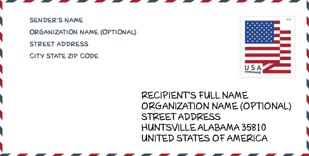
Envelope Example

This is an example of a US zip envelope. You can use a 5-digit zipcode or a detailed 9-digit zipcode to copy the mail in the following address format.
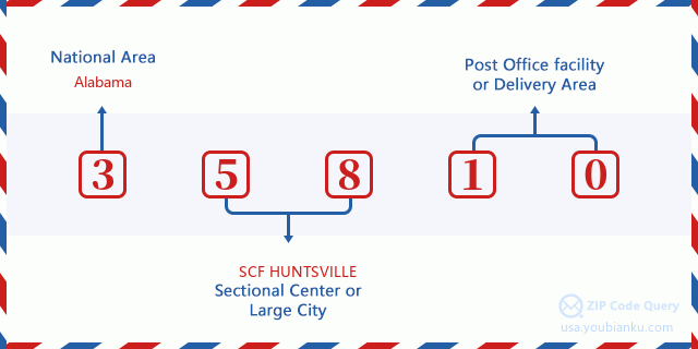
35810 Basic Meaning
What does each digit of ZIP Code 35810 stands for? The first digit designates a national area, which ranges from zero for the Northeast to nine for the far West. The 2-3 digits are the code of a sectional center facility in that region. The last two digits designate small post offices or postal zones.
Online Map

This is online map of the address Huntsville, Alabama, United States. You may use button to move and zoom in / out. The map information is for reference only.
Library

This is the ZIP Code 35810 - Library page list. Its detail Library Name, Address, City, State, ZIP Code, Phone is as below.
| Name | Address | City | State | ZIP Code | Phone |
|---|---|---|---|---|---|
| HUNTSVILLE PUBLIC - BESSIE K. RUSSELL BRANCH | 3011-C SPARKMAN DRIVE | HUNTSVILLE | AL | 35810 | (256) 859-9050 |
| HUNTSVILLE PUBLIC - DR. RICHARD SHOWERS, SR. LIBRARY | 4600 BLUE SPRING ROAD | HUNTSVILLE | AL | 35810 | (256) 851-7492 |
School

This is the ZIP Code 35810 - School page list. Its detail School Name, Address, City, State, ZIP Code is as below.
| School Name | Address | City | State | Grades | ZIP Code |
|---|---|---|---|---|---|
| Academy For Academics Arts Elementary School | 4800 Sparkman Drive NE | Huntsville | AL | PK-05 | 35810 |
| Highlands Elementary School | 2500 Barney Terrace NW | Huntsville | AL | PK-06 | 35810 |
| Lakewood Elementary School | 3501 Kenwood Dr NW | Huntsville | AL | PK-06 | 35810 |
| Montview Elementary School | 2600 Garvin Rd NW | Huntsville | AL | PK-06 | 35810 |
| Rolling Hills Elementary School | 2901 Hilltop Terrace NW | Huntsville | AL | PK-06 | 35810 |
| James Dawson Elementary | 5308 Mastin Lake Rd NW | Huntsville | AL | PK-06 | 35810 |
| Ronald McNair 78 | 5000 Pulaski Pike | Huntsville | AL | 07-08 | 35810 |
| Jemison High School | 5000 Pulaski Pike | Huntsville | AL | 09-12 | 35810 |
| Academy for Academics and Arts Middle School | 4800 Sparkman Drive NE | Huntsville | AL | 06-08 | 35810 |
| Academy For Science Foreign Language Middle School | 3221 Mastin Lake Road | Huntsville | AL | 06-08 | 35810 |
Population for ZIP Code 35810

What is the total population in ZIP Code 35810? Below is detail information.
- Population for ZIP Code 35810: 30,662
- 2010 Population: 30,617
The 2020 demographic statistics are in progress. The current population in ZIP code 35810 is 30,662, and the population in 2010 is 30,617.
Gender

In all the statistical population, the male population is 14,335, the female population is 16,282.
- Male Population: 14,335
- Female Population: 16,282
Race

In all the statistical population, the male population is 14,335, the female population is 16,282.
- White Population: 6,574
- Black Population: 23,428
- Hispanic Population: 1,174
- Asian Population: 248
- Hawaiian Population: 64
- Indian Population: 348
- Other Population: 730
Age

In all the statistical population, the White population is 6,574, the Black population is 23,428, the Hispanic population is 1,174, the Asian population is 248, the Hawaiian population is 64, the Indian Ppopulation is 348 and Other population is 730.
- Age's Median: 34.8
- Median of male age: 31.4
- Median of female age: 37.8
Households for ZIP Code 35810
ZIP code 35810 has 11,594 households, with an average number of 2.48 persons per household. The average income per household in Zip code 35810 is 37,879 USD, and the average house value is 85,500 USD.
- Households Per Zipcode: 11,594
- Persons Per Household: 2.48
- Average House Value: 85,500
- Income Per Household: 37,879
Geographic

The latitude of the Zip code 35810 is 34.804218, the longitude is -86.592350, and the elevation is 733. It has land area of 28.804 square miles, and water area of 0.04 square miles. The time zone for ZIP code 35810 is Central (GMT -06:00). Daylight saving time should be observed in the area where the zip code is located.
- Latitude: 34.804218
- Longitude: -86.592350
- Elevation: 733
- Land Area: 28.804
- Water Area: 0.04
- Time Zone: Central (GMT -06:00)
- Region: South
- Division: East South Central
- Day Light Saving: Y
Congressional District

The Congressional District for ZIP code 35810 is Alabama's 05th congressional district, the Congressional Land Area is 3677.31 square mile.
- Congressional District: 05th
- Congressional Land Area: 3677.31
Delivery

In the ZIP code 35810, there are 12,364 residential delivery mailboxes and centralized units, and 528 commercial delivery mailbox and centralized units, 11,219 single family deliveries and 631 multifamily deliveries, and the box count is 13,661. The main post office has city delivery carrier routes for the ZIP code 35810.
- Delivery Residential: 12,364
- Delivery Business: 528
- Delivery Total: 13,661
- Single Family Delivery Units: 11,219
- Multi Family Delivery Units: 631
- City Delivery Indicator: Y
Business

In ZIP code 35810, the number of business is 341, the number of employee is 5,151, the business first quarter payroll is 50,271,000 USD, the business annual payroll is 216,130,000 USD.
- Number Of Businesses: 341
- Number Of Employees: 5,151
- Business First Quarter Payroll: 50,271,000
- Business Annual Payroll: 216,130,000
Social Security Benefits

There are 6,985 beneficiaries with benefits in current-payment status for ZIP code 35810, of which 4,420 are retired workers, 1,385 are disabled workers, 450 are widow(er)s and parents, 130 are spouses and 600 are children. The number of beneficiaries aged 65 or older is 4,575. The total monthly benefits are 8,592,000 USD, of which 6,030,000 USD for retired workers, 524,000 USD for widow(er)s and parents.
- Total Number: 6,985
- Retired workers Number: 4,420
- Disabled workers Number: 1,385
- Widow(er)s and parents Number: 450
- Spouses Number: 130
- Children Number: 600
- All beneficiaries per month: 8,592,000
- Retired workers per month: 6,030,000
- Widow(er)s and parents per month: 524,000
- Number of beneficiaries aged 65 or older: 4,575


Add new comment