ZIP Code: 40160, Radcliff, KY
ZIP Code 40160 is located in Radcliff, Kentucky. Its detail State, County, City, Longitude, Latitude, Envelope Example, Population is as below.

ZIP Code 40160 Information

-
-
Country:
U.S. - United States
State:
County FIPS:
21093
County:
City:
Area Code:
City Type ?In many cases, a ZIP Code can have multiple "names", meaning cities, towns, or subdivisions, in its boundaries. However, it will ALWAYS have exactly 1 "default" name. D - Default - This is the "preferred" name - by the USPS - for a city. Each ZIP Code has one - and only one - "default" name. In most cases, this is what people who live in that area call the city as well. A - Acceptable - This name can be used for mailing purposes. Often times alternative names are large neighborhoods or sections of the city/town. In some cases a ZIP Code may have several "acceptable" names which is used to group towns under one ZIP Code. N - Not Acceptable - A "not acceptable" name is, in many cases, a nickname that residents give that location. According to the USPS, you should NOT send mail to that ZIP Code using the "not acceptable" name when mailing.:
D (Default)
ZIP Code:
40160
❓What does D (Default) mean? This is the "preferred" name - by the USPS - for a city. Each ZIP Code has one - and only one - "default" name. In most cases, this is what people who live in that area call the city as well.
-


-
Iconic US Landmark Legacy Designs
Get PNG, SVG, EPS, AI, PDF Versions at Just $0.1
 Download Now
-


ZipCodeCraft
ZIP Code 40160 Plus 4
ZIP Code 5 plus 4 is the extension of 5-digit zip code, It can be used to locate a more detailed location. The last four digits designate segment or one side of a street or an apartment. You can find the ZIP+4 code and corresponding address of the zip code 40160 below.
| ZIP Code 5 Plus 4 | Address |
|---|---|
| 40160-1000 | 2152 S DIXIE BLVD, RADCLIFF, KY |
| 40160-1001 | 100 ADENA LOOP, RADCLIFF, KY |
| 40160-1006 | 1401 HARGAN ST, RADCLIFF, KY |
| 40160-1007 | 1400 HARGAN ST, RADCLIFF, KY |
| 40160-1008 | 1501 HARGAN ST, RADCLIFF, KY |
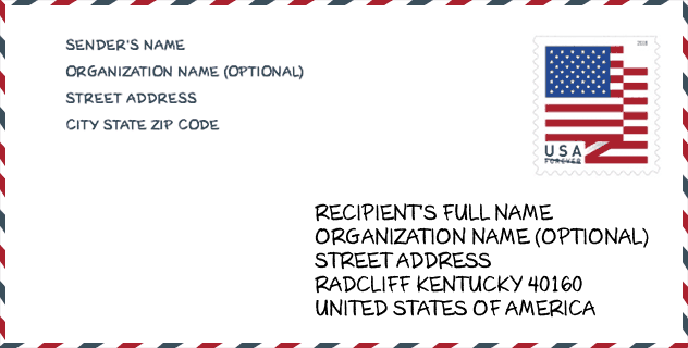
Envelope Example

This is an example of a US zip envelope. You can use a 5-digit zipcode or a detailed 9-digit zipcode to copy the mail in the following address format.
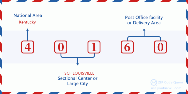
40160 Basic Meaning
What does each digit of ZIP Code 40160 stands for? The first digit designates a national area, which ranges from zero for the Northeast to nine for the far West. The 2-3 digits are the code of a sectional center facility in that region. The last two digits designate small post offices or postal zones.
Online Map

This is online map of the address Radcliff, Kentucky, United States. You may use button to move and zoom in / out. The map information is for reference only.
Hospital

This is the ZIP Code 40160 - Hospital page list. Its detail Hospital Name, Street, City, State, ZIP Code, Phone is as below.
- Name: LINCOLN TRAIL BEHAVIORAL HEALTH SYSTEM
- Address: RADCLIFF
- City: 3909 S WILSON ROAD
- State: KY
- ZIP Code: 40160
- Phone: (270) 351-9444
Library

This is the ZIP Code 40160 - Library page list. Its detail Library Name, Address, City, State, ZIP Code, Phone is as below.
- Name: NORTH BRANCH
- Address: 800 SOUTH LOGSDON PARKWAY
- City: RADCLIFF
- State: KY - Kentucky
- ZIP Code: 40160
- Phone: (270) 351-9999
School

This is the ZIP Code 40160 - School page list. Its detail School Name, Address, City, State, ZIP Code is as below.
| School Name | Address | City | State | Grades | ZIP Code |
|---|---|---|---|---|---|
| North Hardin High School | 801 S Logsdon Parkway | Radcliff | KY | UG | 40160 |
| Radcliff Elementary School | 1145 S. Dixie Blvd | Radcliff | KY | UG | 40160 |
| North Middle School | 100 Trojan Way | Radcliff | KY | UG | 40160 |
| Woodland Elementary School | 6000 S Woodland Dr | Radcliff | KY | UG | 40160 |
| Meadow View Elementary School | 1255 West Vine St | Radcliff | KY | UG | 40160 |
| Lincoln Trail Behavioral Health Systems | 3909 S. Wilson Road | Radcliff | KY | UG | 40160 |
| North Park Elementary School | 1080 S. Logsdon Parkway | Radcliff | KY | UG | 40160 |
Population for ZIP Code 40160

What is the total population in ZIP Code 40160? Below is detail information.
- Population for ZIP Code 40160: 25,089
- 2010 Population: 23,574
The 2020 demographic statistics are in progress. The current population in ZIP code 40160 is 25,089, and the population in 2010 is 23,574.
Gender

In all the statistical population, the male population is 11,483, the female population is 12,091.
- Male Population: 11,483
- Female Population: 12,091
Race

In all the statistical population, the male population is 11,483, the female population is 12,091.
- White Population: 16,055
- Black Population: 6,418
- Hispanic Population: 1,916
- Asian Population: 1,109
- Hawaiian Population: 300
- Indian Population: 460
- Other Population: 777
Age

In all the statistical population, the White population is 16,055, the Black population is 6,418, the Hispanic population is 1,916, the Asian population is 1,109, the Hawaiian population is 300, the Indian Ppopulation is 460 and Other population is 777.
- Age's Median: 33.2
- Median of male age: 32.0
- Median of female age: 34.7
Households for ZIP Code 40160
ZIP code 40160 has 9,316 households, with an average number of 2.51 persons per household. The average income per household in Zip code 40160 is 45,944 USD, and the average house value is 126,500 USD.
- Households Per Zipcode: 9,316
- Persons Per Household: 2.51
- Average House Value: 126,500
- Income Per Household: 45,944
Geographic

The latitude of the Zip code 40160 is 37.817462, the longitude is -85.938400, and the elevation is 767. It has land area of 16.848 square miles, and water area of 0.061 square miles. The time zone for ZIP code 40160 is Eastern (GMT -05:00). Daylight saving time should be observed in the area where the zip code is located.
- Latitude: 37.817462
- Longitude: -85.938400
- Elevation: 767
- Land Area: 16.848
- Water Area: 0.061
- Time Zone: Eastern (GMT -05:00)
- Region: South
- Division: East South Central
- Day Light Saving: Y
Congressional District

The Congressional District for ZIP code 40160 is Kentucky's 2nd congressional district, the Congressional Land Area is 7177.44 square mile.
- Congressional District: 2nd
- Congressional Land Area: 7177.44
Delivery

In the ZIP code 40160, there are 9,996 residential delivery mailboxes and centralized units, and 623 commercial delivery mailbox and centralized units, 7,969 single family deliveries and 316 multifamily deliveries, and the box count is 10,600. The main post office has city delivery carrier routes for the ZIP code 40160.
- Delivery Residential: 9,996
- Delivery Business: 623
- Delivery Total: 10,600
- Single Family Delivery Units: 7,969
- Multi Family Delivery Units: 316
- City Delivery Indicator: Y
Business

In ZIP code 40160, the number of business is 336, the number of employee is 4,079, the business first quarter payroll is 27,327,000 USD, the business annual payroll is 113,461,000 USD.
- Number Of Businesses: 336
- Number Of Employees: 4,079
- Business First Quarter Payroll: 27,327,000
- Business Annual Payroll: 113,461,000
Social Security Benefits

There are 4,880 beneficiaries with benefits in current-payment status for ZIP code 40160, of which 2,700 are retired workers, 1,100 are disabled workers, 380 are widow(er)s and parents, 175 are spouses and 525 are children. The number of beneficiaries aged 65 or older is 2,910. The total monthly benefits are 5,579,000 USD, of which 3,450,000 USD for retired workers, 454,000 USD for widow(er)s and parents.
- Total Number: 4,880
- Retired workers Number: 2,700
- Disabled workers Number: 1,100
- Widow(er)s and parents Number: 380
- Spouses Number: 175
- Children Number: 525
- All beneficiaries per month: 5,579,000
- Retired workers per month: 3,450,000
- Widow(er)s and parents per month: 454,000
- Number of beneficiaries aged 65 or older: 2,910


Add new comment