ZIP Code: 40211, Louisville, KY
ZIP Code 40211 is located in Louisville, Kentucky. Its detail State, County, City, Longitude, Latitude, Envelope Example, Population is as below.
ZIP Code 40211 Information

-
-
Country:
U.S. - United States
State:
County FIPS:
21111
City:
Area Code:
City Type ?In many cases, a ZIP Code can have multiple "names", meaning cities, towns, or subdivisions, in its boundaries. However, it will ALWAYS have exactly 1 "default" name. D - Default - This is the "preferred" name - by the USPS - for a city. Each ZIP Code has one - and only one - "default" name. In most cases, this is what people who live in that area call the city as well. A - Acceptable - This name can be used for mailing purposes. Often times alternative names are large neighborhoods or sections of the city/town. In some cases a ZIP Code may have several "acceptable" names which is used to group towns under one ZIP Code. N - Not Acceptable - A "not acceptable" name is, in many cases, a nickname that residents give that location. According to the USPS, you should NOT send mail to that ZIP Code using the "not acceptable" name when mailing.:
D (Default)
ZIP Code:
40211
❓What does D (Default) mean? This is the "preferred" name - by the USPS - for a city. Each ZIP Code has one - and only one - "default" name. In most cases, this is what people who live in that area call the city as well.
-


-
Iconic US Landmark Legacy Designs
Get PNG, SVG, EPS, AI, PDF Versions at Just $0.1
 Download Now
-


ZipCodeCraft
ZIP Code 40211 Plus 4
ZIP Code 5 plus 4 is the extension of 5-digit zip code, It can be used to locate a more detailed location. The last four digits designate segment or one side of a street or an apartment. You can find the ZIP+4 code and corresponding address of the zip code 40211 below.
| ZIP Code 5 Plus 4 | Address |
|---|---|
| 40211-1000 | 601 S 26TH ST, LOUISVILLE, KY |
| 40211-1001 | 2101 W BROADWAY, LOUISVILLE, KY |
| 40211-1002 | 2100 W BROADWAY, LOUISVILLE, KY |
| 40211-1003 | 2201 W BROADWAY, LOUISVILLE, KY |
| 40211-1004 | 2200 W BROADWAY, LOUISVILLE, KY |
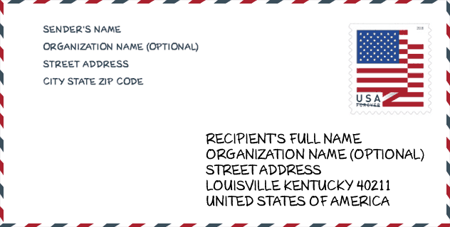
Envelope Example

This is an example of a US zip envelope. You can use a 5-digit zipcode or a detailed 9-digit zipcode to copy the mail in the following address format.
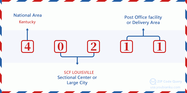
40211 Basic Meaning
What does each digit of ZIP Code 40211 stands for? The first digit designates a national area, which ranges from zero for the Northeast to nine for the far West. The 2-3 digits are the code of a sectional center facility in that region. The last two digits designate small post offices or postal zones.
Online Map

This is online map of the address Louisville, Kentucky, United States. You may use button to move and zoom in / out. The map information is for reference only.
Library

This is the ZIP Code 40211 - Library page list. Its detail Library Name, Address, City, State, ZIP Code, Phone is as below.
- Name: SHAWNEE BRANCH
- Address: 3912 WEST BROADWAY
- City: LOUISVILLE
- State: KY - Kentucky
- ZIP Code: 40211
- Phone: (502) 574-1722
School

This is the ZIP Code 40211 - School page list. Its detail School Name, Address, City, State, ZIP Code is as below.
| School Name | Address | City | State | Grades | ZIP Code |
|---|---|---|---|---|---|
| Cane Run Elementary | 3951 Cane Run Rd | Louisville | KY | UG | 40211 |
| Brandeis Elementary | 2817 West Kentucky | Louisville | KY | UG | 40211 |
| Foster Traditional Academy | 1401 South 41st Street | Louisville | KY | UG | 40211 |
| King Elementary | 4325 Vermont Ave | Louisville | KY | UG | 40211 |
| Maupin Elementary | 1312 Catalpa Street | Louisville | KY | UG | 40211 |
| Carter Traditional Elementary | 3600 Bohne Ave | Louisville | KY | UG | 40211 |
| Kennedy Montessori Elementary | 3800 Gibson Lane | Louisville | KY | UG | 40211 |
| DuValle Education Center | 3610 Bohne Ave | Louisville | KY | UG | 40211 |
Population for ZIP Code 40211

What is the total population in ZIP Code 40211? Below is detail information.
- Population for ZIP Code 40211: 22,698
- 2010 Population: 22,612
The 2020 demographic statistics are in progress. The current population in ZIP code 40211 is 22,698, and the population in 2010 is 22,612.
Gender

In all the statistical population, the male population is 10,112, the female population is 12,500.
- Male Population: 10,112
- Female Population: 12,500
Race

In all the statistical population, the male population is 10,112, the female population is 12,500.
- White Population: 1,116
- Black Population: 21,626
- Hispanic Population: 196
- Asian Population: 59
- Hawaiian Population: 17
- Indian Population: 189
- Other Population: 108
Age

In all the statistical population, the White population is 1,116, the Black population is 21,626, the Hispanic population is 196, the Asian population is 59, the Hawaiian population is 17, the Indian Ppopulation is 189 and Other population is 108.
- Age's Median: 35.2
- Median of male age: 32.4
- Median of female age: 37.6
Households for ZIP Code 40211
ZIP code 40211 has 9,064 households, with an average number of 2.49 persons per household. The average income per household in Zip code 40211 is 27,565 USD, and the average house value is 66,500 USD.
- Households Per Zipcode: 9,064
- Persons Per Household: 2.49
- Average House Value: 66,500
- Income Per Household: 27,565
Geographic

The latitude of the Zip code 40211 is 38.232512, the longitude is -85.827156, and the elevation is 448. It has land area of 7.481 square miles, and water area of 1.185 square miles. The time zone for ZIP code 40211 is Eastern (GMT -05:00). Daylight saving time should be observed in the area where the zip code is located.
- Latitude: 38.232512
- Longitude: -85.827156
- Elevation: 448
- Land Area: 7.481
- Water Area: 1.185
- Time Zone: Eastern (GMT -05:00)
- Region: South
- Division: East South Central
- Day Light Saving: Y
Congressional District

The Congressional District for ZIP code 40211 is Kentucky's 3rd congressional district, the Congressional Land Area is 319.34 square mile.
- Congressional District: 3rd
- Congressional Land Area: 319.34
Delivery

In the ZIP code 40211, there are 9,116 residential delivery mailboxes and centralized units, and 522 commercial delivery mailbox and centralized units, 7,835 single family deliveries and 742 multifamily deliveries, and the box count is 10,354. The main post office has city delivery carrier routes for the ZIP code 40211.
- Delivery Residential: 9,116
- Delivery Business: 522
- Delivery Total: 10,354
- Single Family Delivery Units: 7,835
- Multi Family Delivery Units: 742
- City Delivery Indicator: Y
Business

In ZIP code 40211, the number of business is 265, the number of employee is 5,402, the business first quarter payroll is 69,696,000 USD, the business annual payroll is 271,099,000 USD.
- Number Of Businesses: 265
- Number Of Employees: 5,402
- Business First Quarter Payroll: 69,696,000
- Business Annual Payroll: 271,099,000
Social Security Benefits

There are 4,960 beneficiaries with benefits in current-payment status for ZIP code 40211, of which 2,795 are retired workers, 1,360 are disabled workers, 265 are widow(er)s and parents, 45 are spouses and 495 are children. The number of beneficiaries aged 65 or older is 2,820. The total monthly benefits are 5,397,000 USD, of which 3,407,000 USD for retired workers, 302,000 USD for widow(er)s and parents.
- Total Number: 4,960
- Retired workers Number: 2,795
- Disabled workers Number: 1,360
- Widow(er)s and parents Number: 265
- Spouses Number: 45
- Children Number: 495
- All beneficiaries per month: 5,397,000
- Retired workers per month: 3,407,000
- Widow(er)s and parents per month: 302,000
- Number of beneficiaries aged 65 or older: 2,820


Add new comment