United States ZIP Code: 40229
This is the Kentucky ZIP Code 40229 page list. Its detail State, County, City, Longitude, Latitude, Envelope Example, Population is as below.
ZIP Code 40229 Information

-
-
Country:
U.S. - United States
State:
State FIPS:
21
Area Code:
ZIP Code:
40229
ZIP Type:
S (Standard)
❓What does S (Standard) mean? A "standard" ZIP Code is what most people think of when they talk about ZIP Codes - essentially a town, city, or a division of a city that has mail service.
-


-
Iconic US Landmark Legacy Designs
Get PNG, SVG, EPS, AI, PDF Versions at Just $0.1
 Download Now
-


ZipCodeCraft
ZIP Code 40229 - City

This is the city information corresponding to 40229:
| State | County | City | City Type ?In many cases, a ZIP Code can have multiple "names", meaning cities, towns, or subdivisions, in its boundaries. However, it will ALWAYS have exactly 1 "default" name. D - Default - This is the "preferred" name - by the USPS - for a city. Each ZIP Code has one - and only one - "default" name. In most cases, this is what people who live in that area call the city as well. A - Acceptable - This name can be used for mailing purposes. Often times alternative names are large neighborhoods or sections of the city/town. In some cases a ZIP Code may have several "acceptable" names which is used to group towns under one ZIP Code. N - Not Acceptable - A "not acceptable" name is, in many cases, a nickname that residents give that location. According to the USPS, you should NOT send mail to that ZIP Code using the "not acceptable" name when mailing. | ZIP Code |
|---|---|---|---|---|
| KY | Jefferson | Louisville | D (Default) | 40229 |
| KY | Jefferson | Okolona | A (Acceptable) | 40229 |
❓What does D (Default) mean? This is the "preferred" name - by the USPS - for a city. Each ZIP Code has one - and only one - "default" name. In most cases, this is what people who live in that area call the city as well.
❓What does A (Acceptable) mean? This name can be used for mailing purposes. Often times alternative names are large neighborhoods or sections of the city/town. In some cases a ZIP Code may have several "acceptable" names which is used to group towns under one ZIP Code.
ZIP Code 40229 Plus 4
ZIP Code 5 plus 4 is the extension of 5-digit zip code, It can be used to locate a more detailed location. The last four digits designate segment or one side of a street or an apartment. You can find the ZIP+4 code and corresponding address of the zip code 40229 below.
| ZIP Code 5 Plus 4 | Address |
|---|---|
| 40229-1000 | 3814 FREEDOM WAY #00000001 , LOUISVILLE, KY |
| 40229-1001 | 3701 ASTROCRAFT DR, LOUISVILLE, KY |
| 40229-1002 | 3700 ASTROCRAFT DR, LOUISVILLE, KY |
| 40229-1003 | 3801 ASTROCRAFT DR, LOUISVILLE, KY |
| 40229-1004 | 3800 ASTROCRAFT DR, LOUISVILLE, KY |
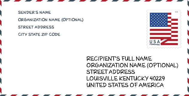
Envelope Example

This is an example of a US zip envelope. You can use a 5-digit zipcode or a detailed 9-digit zipcode to copy the mail in the following address format.
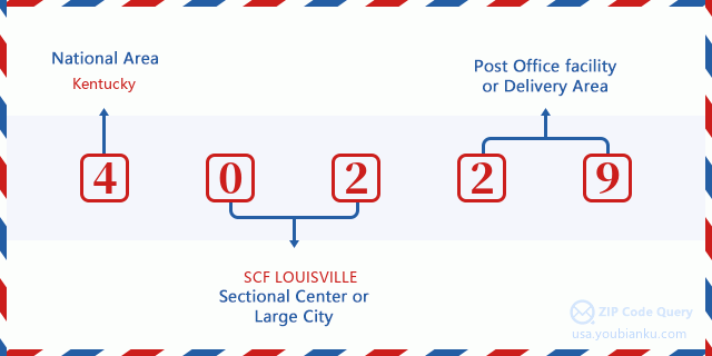
40229 Basic Meaning
What does each digit of ZIP Code 40229 stands for? The first digit designates a national area, which ranges from zero for the Northeast to nine for the far West. The 2-3 digits are the code of a sectional center facility in that region. The last two digits designate small post offices or postal zones.
Online Map

This is online map of the address Okolona, Kentucky, United States. You may use button to move and zoom in / out. The map information is for reference only.
Library

This is the ZIP Code 40229 - Library page list. Its detail Library Name, Address, City, State, ZIP Code, Phone is as below.
- Name: HILLVIEW LIBRARY
- Address: 155 TERRY BOULEVARD
- City: LOUISVILLE
- State: KY - Kentucky
- ZIP Code: 40229
- Phone: (502) 957-5759
School

This is the ZIP Code 40229 - School page list. Its detail School Name, Address, City, State, ZIP Code is as below.
| School Name | Address | City | State | Grades | ZIP Code |
|---|---|---|---|---|---|
| Blue Lick Elementary | 9801 Blue Lick Road | Louisville | KY | UG | 40229 |
| Wilt Elementary | 6700 Price Lane | Louisville | KY | UG | 40229 |
| Laukhuf Elementary | 5100 Capewood Dr | Louisville | KY | UG | 40229 |
| Knight Middle | 9803 Blue Lick Road | Louisville | KY | UG | 40229 |
Population for ZIP Code 40229

What is the total population in ZIP Code 40229? Below is detail information.
- Population for ZIP Code 40229: 42,153
- 2010 Population: 36,852
The 2020 demographic statistics are in progress. The current population in ZIP code 40229 is 42,153, and the population in 2010 is 36,852.
Gender

In all the statistical population, the male population is 18,248, the female population is 18,604.
- Male Population: 18,248
- Female Population: 18,604
Race

In all the statistical population, the male population is 18,248, the female population is 18,604.
- White Population: 33,615
- Black Population: 2,501
- Hispanic Population: 1,369
- Asian Population: 560
- Hawaiian Population: 41
- Indian Population: 273
- Other Population: 585
Age

In all the statistical population, the White population is 33,615, the Black population is 2,501, the Hispanic population is 1,369, the Asian population is 560, the Hawaiian population is 41, the Indian Ppopulation is 273 and Other population is 585.
- Age's Median: 34.8
- Median of male age: 34.1
- Median of female age: 35.6
Households for ZIP Code 40229
ZIP code 40229 has 13,753 households, with an average number of 2.68 persons per household. The average income per household in Zip code 40229 is 58,685 USD, and the average house value is 132,000 USD.
- Households Per Zipcode: 13,753
- Persons Per Household: 2.68
- Average House Value: 132,000
- Income Per Household: 58,685
Geographic

The latitude of the Zip code 40229 is 38.090425, the longitude is -85.652049, and the elevation is 595. It has land area of 19.746 square miles, and water area of 0.227 square miles. The time zone for ZIP code 40229 is Eastern (GMT -05:00). Daylight saving time should be observed in the area where the zip code is located.
- Latitude: 38.090425
- Longitude: -85.652049
- Elevation: 595
- Land Area: 19.746
- Water Area: 0.227
- Time Zone: Eastern (GMT -05:00)
- Region: South
- Division: East South Central
- Day Light Saving: Y
Congressional District

The Congressional District for ZIP code 40229 is Kentucky's 2nd|3rd congressional district, the Congressional Land Area is 7177.44|319.34 square mile.
- Congressional District: 2nd|3rd
- Congressional Land Area: 7177.44|319.34
Delivery

In the ZIP code 40229, there are 15,729 residential delivery mailboxes and centralized units, and 421 commercial delivery mailbox and centralized units, 12,831 single family deliveries and 801 multifamily deliveries, and the box count is 17,514. The main post office has city delivery carrier routes for the ZIP code 40229.
- Delivery Residential: 15,729
- Delivery Business: 421
- Delivery Total: 17,514
- Single Family Delivery Units: 12,831
- Multi Family Delivery Units: 801
- City Delivery Indicator: Y
Business

In ZIP code 40229, the number of business is 386, the number of employee is 8,545, the business first quarter payroll is 92,847,000 USD, the business annual payroll is 362,220,000 USD.
- Number Of Businesses: 386
- Number Of Employees: 8,545
- Business First Quarter Payroll: 92,847,000
- Business Annual Payroll: 362,220,000
Social Security Benefits

There are 6,950 beneficiaries with benefits in current-payment status for ZIP code 40229, of which 4,185 are retired workers, 1,485 are disabled workers, 485 are widow(er)s and parents, 190 are spouses and 605 are children. The number of beneficiaries aged 65 or older is 4,490. The total monthly benefits are 9,223,000 USD, of which 6,126,000 USD for retired workers, 680,000 USD for widow(er)s and parents.
- Total Number: 6,950
- Retired workers Number: 4,185
- Disabled workers Number: 1,485
- Widow(er)s and parents Number: 485
- Spouses Number: 190
- Children Number: 605
- All beneficiaries per month: 9,223,000
- Retired workers per month: 6,126,000
- Widow(er)s and parents per month: 680,000
- Number of beneficiaries aged 65 or older: 4,490


Add new comment