United States ZIP Code: 40601
This is the Kentucky ZIP Code 40601 page list. Its detail State, County, City, Longitude, Latitude, Envelope Example, Population is as below.

ZIP Code 40601 Information

-
-
Country:
U.S. - United States
State:
State FIPS:
21
Area Code:
ZIP Code:
40601
ZIP Type:
S (Standard)
❓What does S (Standard) mean? A "standard" ZIP Code is what most people think of when they talk about ZIP Codes - essentially a town, city, or a division of a city that has mail service.
ZIP Code 40601 - City

This is the city information corresponding to 40601:
| State | County | City | City Type ?In many cases, a ZIP Code can have multiple "names", meaning cities, towns, or subdivisions, in its boundaries. However, it will ALWAYS have exactly 1 "default" name. D - Default - This is the "preferred" name - by the USPS - for a city. Each ZIP Code has one - and only one - "default" name. In most cases, this is what people who live in that area call the city as well. A - Acceptable - This name can be used for mailing purposes. Often times alternative names are large neighborhoods or sections of the city/town. In some cases a ZIP Code may have several "acceptable" names which is used to group towns under one ZIP Code. N - Not Acceptable - A "not acceptable" name is, in many cases, a nickname that residents give that location. According to the USPS, you should NOT send mail to that ZIP Code using the "not acceptable" name when mailing. | ZIP Code |
|---|---|---|---|---|
| KY | Franklin | Frankfort | D (Default) | 40601 |
| KY | Franklin | Hatton | A (Acceptable) | 40601 |
❓What does D (Default) mean? This is the "preferred" name - by the USPS - for a city. Each ZIP Code has one - and only one - "default" name. In most cases, this is what people who live in that area call the city as well.
❓What does A (Acceptable) mean? This name can be used for mailing purposes. Often times alternative names are large neighborhoods or sections of the city/town. In some cases a ZIP Code may have several "acceptable" names which is used to group towns under one ZIP Code.
ZIP Code 40601 Plus 4
ZIP Code 5 plus 4 is the extension of 5-digit zip code, It can be used to locate a more detailed location. The last four digits designate segment or one side of a street or an apartment. You can find the ZIP+4 code and corresponding address of the zip code 40601 below.
| ZIP Code 5 Plus 4 | Address |
|---|---|
| 40601-0001 | 300 DENISON WAY, FRANKFORT, KY |
| 40601-0002 | 100 N DANBROOK WAY, FRANKFORT, KY |
| 40601-0003 | 200 DENISON WAY, FRANKFORT, KY |
| 40601-0004 | 100 BRODERICK WAY, FRANKFORT, KY |
| 40601-0005 | 100 DANBROOK WAY, FRANKFORT, KY |
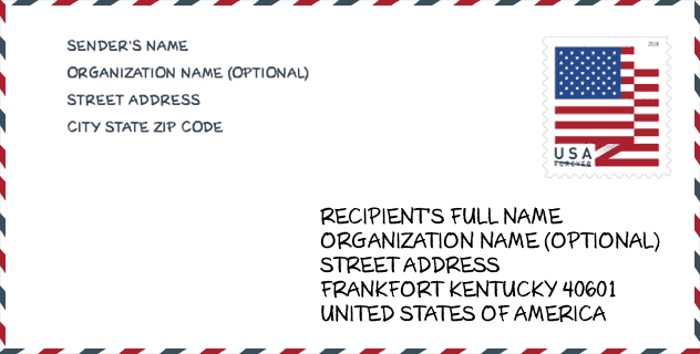
Envelope Example

This is an example of a US zip envelope. You can use a 5-digit zipcode or a detailed 9-digit zipcode to copy the mail in the following address format.
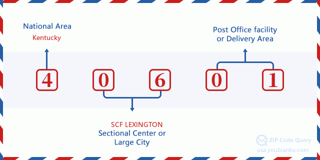
40601 Basic Meaning
What does each digit of ZIP Code 40601 stands for? The first digit designates a national area, which ranges from zero for the Northeast to nine for the far West. The 2-3 digits are the code of a sectional center facility in that region. The last two digits designate small post offices or postal zones.
Online Map

This is online map of the address Hatton, Kentucky, United States. You may use button to move and zoom in / out. The map information is for reference only.
Hospital

This is the ZIP Code 40601 - Hospital page list. Its detail Hospital Name, Street, City, State, ZIP Code, Phone is as below.
- Name: FRANKFORT REGIONAL MEDICAL CENTER
- Address: FRANKFORT
- City: 299 KINGS DAUGHTERS DRIVE
- State: KY
- ZIP Code: 40601
- Phone: (502) 875-5240
Museum

This is the ZIP Code 40601 - Museum page list. Its detail Museum Name, Street, City, State, ZIP Code, Phone is as below.
| Name | Street | City | State | ZIP Code | Phone |
| VEST-LINDSEY HOUSE | 401 WAPPING ST | FRANKFORT | KY | 40601 | (502) 564-0900 |
| FRANKLIN COUNTY TRUST FOR HISTORIC PRESERVATION | 305 OLD PEAKS MILL ROAD | FRANKFORT | KY | 40601 | |
| JACKSON HALL GALLERY | 400 EAST MAIN STREET | FRANKFORT | KY | 40601 | (502) 597-6000 |
Library

This is the ZIP Code 40601 - Library page list. Its detail Library Name, Address, City, State, ZIP Code, Phone is as below.
| Name | Address | City | State | ZIP Code | Phone |
|---|---|---|---|---|---|
| FRANKLIN COUNTY LIBRARY DISTRICT | 319 WAPPING STREET | FRANKFORT | KY | 40601 | (502) 352-2665 |
| PAUL SAWYIER PUBLIC LIBRARY | 319 WAPPING STREET | FRANKFORT | KY | 40601 | (520) 352-2665 |
School

This is the ZIP Code 40601 - School page list. Its detail School Name, Address, City, State, ZIP Code is as below.
| School Name | Address | City | State | Grades | ZIP Code |
|---|---|---|---|---|---|
| Second Street School | 506 W 2nd St | Frankfort | KY | UG | 40601 |
| Frankfort High School | 328 Shelby St | Frankfort | KY | UG | 40601 |
| Panther Transition Academy | 328 Shelby Street | Frankfort | KY | UG | 40601 |
| Frankfort Early Learning Academy | 506 West Second Street | Frankfort | KY | UG | 40601 |
| Bondurant Middle School | Bondurant Dr | Frankfort | KY | UG | 40601 |
| Collins Lane | 1 Cougar Lane | Frankfort | KY | UG | 40601 |
| Elkhorn Middle School | 1060 E Main St | Frankfort | KY | UG | 40601 |
| Elkhorn Elementary School | 928 E Main St | Frankfort | KY | UG | 40601 |
| Franklin County High School | 1100 E Main St | Frankfort | KY | UG | 40601 |
| Hearn Elementary | 300 Copperleaf Blvd | Frankfort | KY | UG | 40601 |
| Peaks Mill Elementary | 100 Peaks Mill Rd | Frankfort | KY | UG | 40601 |
| Western Hills High School | 100 Doctors Dr | Frankfort | KY | UG | 40601 |
| The Academy | 400 Democrat Drive | Frankfort | KY | UG | 40601 |
| Westridge Elementary | 200 Oak Ridge Drive | Frankfort | KY | UG | 40601 |
| Bridgeport Elementary School | 10 Doctors Dr | Frankfort | KY | UG | 40601 |
| Franklin County Career and Technical Ctr | 1106 E Main St | Frankfort | KY | UG | 40601 |
| Early Learning Village | 200 Laralan Ave | Frankfort | KY | UG | 40601 |
| William Cofield High School | 1106 East Main Street | Frankfort | KY | UG | 40601 |
Population for ZIP Code 40601

What is the total population in ZIP Code 40601? Below is detail information.
- Population for ZIP Code 40601: 53,803
- 2010 Population: 49,566
The 2020 demographic statistics are in progress. The current population in ZIP code 40601 is 53,803, and the population in 2010 is 49,566.
Gender

In all the statistical population, the male population is 23,815, the female population is 25,751.
- Male Population: 23,815
- Female Population: 25,751
Race

In all the statistical population, the male population is 23,815, the female population is 25,751.
- White Population: 43,012
- Black Population: 5,702
- Hispanic Population: 1,389
- Asian Population: 798
- Hawaiian Population: 30
- Indian Population: 393
- Other Population: 790
Age

In all the statistical population, the White population is 43,012, the Black population is 5,702, the Hispanic population is 1,389, the Asian population is 798, the Hawaiian population is 30, the Indian Ppopulation is 393 and Other population is 790.
- Age's Median: 40.0
- Median of male age: 38.9
- Median of female age: 41.2
Households for ZIP Code 40601
ZIP code 40601 has 20,979 households, with an average number of 2.29 persons per household. The average income per household in Zip code 40601 is 55,322 USD, and the average house value is 142,600 USD.
- Households Per Zipcode: 20,979
- Persons Per Household: 2.29
- Average House Value: 142,600
- Income Per Household: 55,322
Geographic

The latitude of the Zip code 40601 is 38.232567, the longitude is -84.898278, and the elevation is 454. It has land area of 220.602 square miles, and water area of 4.179 square miles. The time zone for ZIP code 40601 is Eastern (GMT -05:00). Daylight saving time should be observed in the area where the zip code is located.
- Latitude: 38.232567
- Longitude: -84.898278
- Elevation: 454
- Land Area: 220.602
- Water Area: 4.179
- Time Zone: Eastern (GMT -05:00)
- Region: South
- Division: East South Central
- Day Light Saving: Y
Congressional District

The Congressional District for ZIP code 40601 is Kentucky's 04th|06th congressional district, the Congressional Land Area is 4382.19|4292.72 square mile.
- Congressional District: 04th|06th
- Congressional Land Area: 4382.19|4292.72
Delivery

In the ZIP code 40601, there are 23,495 residential delivery mailboxes and centralized units, and 1,789 commercial delivery mailbox and centralized units, 18,171 single family deliveries and 1,935 multifamily deliveries, and the box count is 25,206. The main post office has city delivery carrier routes for the ZIP code 40601.
- Delivery Residential: 23,495
- Delivery Business: 1,789
- Delivery Total: 25,206
- Single Family Delivery Units: 18,171
- Multi Family Delivery Units: 1,935
- City Delivery Indicator: Y
Business

In ZIP code 40601, the number of business is 1,157, the number of employee is 16,566, the business first quarter payroll is 150,154,000 USD, the business annual payroll is 627,527,000 USD.
- Number Of Businesses: 1,157
- Number Of Employees: 16,566
- Business First Quarter Payroll: 150,154,000
- Business Annual Payroll: 627,527,000
Social Security Benefits

There are 11,820 beneficiaries with benefits in current-payment status for ZIP code 40601, of which 8,455 are retired workers, 1,745 are disabled workers, 650 are widow(er)s and parents, 225 are spouses and 745 are children. The number of beneficiaries aged 65 or older is 8,625. The total monthly benefits are 15,820,000 USD, of which 12,154,000 USD for retired workers, 864,000 USD for widow(er)s and parents.
- Total Number: 11,820
- Retired workers Number: 8,455
- Disabled workers Number: 1,745
- Widow(er)s and parents Number: 650
- Spouses Number: 225
- Children Number: 745
- All beneficiaries per month: 15,820,000
- Retired workers per month: 12,154,000
- Widow(er)s and parents per month: 864,000
- Number of beneficiaries aged 65 or older: 8,625


Add new comment