United States ZIP Code: 45440
This is the Ohio ZIP Code 45440 page list. Its detail State, County, City, Longitude, Latitude, Envelope Example, Population is as below.

ZIP Code 45440 Information

-


-
Iconic US Landmark Legacy Designs
Get PNG, SVG, EPS, AI, PDF Versions at Just $0.1
 Download Now
-


ZipCodeCraft
ZIP Code 45440 - City

This is the city information corresponding to 45440:
| State | County | City | City Type ?In many cases, a ZIP Code can have multiple "names", meaning cities, towns, or subdivisions, in its boundaries. However, it will ALWAYS have exactly 1 "default" name. D - Default - This is the "preferred" name - by the USPS - for a city. Each ZIP Code has one - and only one - "default" name. In most cases, this is what people who live in that area call the city as well. A - Acceptable - This name can be used for mailing purposes. Often times alternative names are large neighborhoods or sections of the city/town. In some cases a ZIP Code may have several "acceptable" names which is used to group towns under one ZIP Code. N - Not Acceptable - A "not acceptable" name is, in many cases, a nickname that residents give that location. According to the USPS, you should NOT send mail to that ZIP Code using the "not acceptable" name when mailing. | ZIP Code |
|---|---|---|---|---|
| OH | Montgomery | Beaver Creek | N (Not Acceptable) | 45440 |
| OH | Montgomery | Beavercreek | A (Acceptable) | 45440 |
| OH | Montgomery | Beavercreek Township | A (Acceptable) | 45440 |
| OH | Montgomery | Beavercrk Twp | A (Acceptable) | 45440 |
| OH | Montgomery | Centerville | A (Acceptable) | 45440 |
| OH | Montgomery | Dayton | D (Default) | 45440 |
| OH | Montgomery | Kettering | A (Acceptable) | 45440 |
| OH | Montgomery | Sugarcreek Township | A (Acceptable) | 45440 |
| OH | Montgomery | Sugarcrk Twp | A (Acceptable) | 45440 |
❓What does D (Default) mean? This is the "preferred" name - by the USPS - for a city. Each ZIP Code has one - and only one - "default" name. In most cases, this is what people who live in that area call the city as well.
❓What does A (Acceptable) mean? This name can be used for mailing purposes. Often times alternative names are large neighborhoods or sections of the city/town. In some cases a ZIP Code may have several "acceptable" names which is used to group towns under one ZIP Code.
❓What does N (Not Acceptable) mean? A "not acceptable" name is, in many cases, a nickname that residents give that location. According to the USPS, you should NOT send mail to that ZIP Code using the "not acceptable" name when mailing.
ZIP Code 45440 Plus 4
ZIP Code 5 plus 4 is the extension of 5-digit zip code, It can be used to locate a more detailed location. The last four digits designate segment or one side of a street or an apartment. You can find the ZIP+4 code and corresponding address of the zip code 45440 below.
| ZIP Code 5 Plus 4 | Address |
|---|---|
| 45440-0001 | 4300 JUNIPER WAY, BEAVERCREEK, OH |
| 45440-0002 | 4301 JUNIPER WAY, BEAVERCREEK, OH |
| 45440-1000 | 97 MAPLE AVE, DAYTON, OH |
| 45440-1100 | 2250 E STROOP RD, BEAVERCREEK, OH |
| 45440-1101 | 2101 BENDING WILLOW DR, DAYTON, OH |
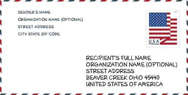
Envelope Example

This is an example of a US zip envelope. You can use a 5-digit zipcode or a detailed 9-digit zipcode to copy the mail in the following address format.
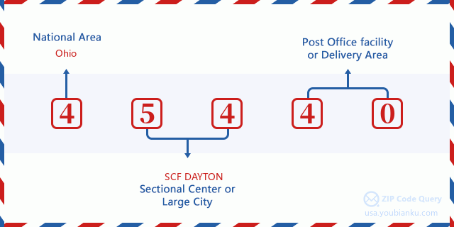
45440 Basic Meaning
What does each digit of ZIP Code 45440 stands for? The first digit designates a national area, which ranges from zero for the Northeast to nine for the far West. The 2-3 digits are the code of a sectional center facility in that region. The last two digits designate small post offices or postal zones.
Online Map

This is online map of the address Sugarcrk Twp, Ohio, United States. You may use button to move and zoom in / out. The map information is for reference only.
University

This is the ZIP Code 45440 - University page list. Its detail university Name, Street, City, State, ZIP Code, Phone is as below.
| Name | Street | City | State | ZIP Code | Phone |
| Advertising Art Educational Services DBA School of Advertising Art | 1725 E David Rd | Kettering | OH | 45440 | - |
| The Modern College of Design | 1725 E David Rd | Kettering | OH | 45440 | (937) 294-0592 |
Population for ZIP Code 45440

What is the total population in ZIP Code 45440? Below is detail information.
- Population for ZIP Code 45440: 22,836
- 2010 Population: 20,734
The 2020 demographic statistics are in progress. The current population in ZIP code 45440 is 22,836, and the population in 2010 is 20,734.
Gender

In all the statistical population, the male population is 10,017, the female population is 10,717.
- Male Population: 10,017
- Female Population: 10,717
Race

In all the statistical population, the male population is 10,017, the female population is 10,717.
- White Population: 19,179
- Black Population: 1,058
- Hispanic Population: 432
- Asian Population: 646
- Hawaiian Population: 26
- Indian Population: 142
- Other Population: 132
Age

In all the statistical population, the White population is 19,179, the Black population is 1,058, the Hispanic population is 432, the Asian population is 646, the Hawaiian population is 26, the Indian Ppopulation is 142 and Other population is 132.
- Age's Median: 42.3
- Median of male age: 40.2
- Median of female age: 44.1
Households for ZIP Code 45440
ZIP code 45440 has 9,075 households, with an average number of 2.27 persons per household. The average income per household in Zip code 45440 is 71,950 USD, and the average house value is 171,800 USD.
- Households Per Zipcode: 9,075
- Persons Per Household: 2.27
- Average House Value: 171,800
- Income Per Household: 71,950
Geographic

The latitude of the Zip code 45440 is 39.669158, the longitude is -84.090296, and the elevation is 936. It has land area of 9.416 square miles, and water area of 0.019 square miles. The time zone for ZIP code 45440 is Eastern (GMT -05:00). Daylight saving time should be observed in the area where the zip code is located.
- Latitude: 39.669158
- Longitude: -84.090296
- Elevation: 936
- Land Area: 9.416
- Water Area: 0.019
- Time Zone: Eastern (GMT -05:00)
- Region: Midwest
- Division: East North Central
- Day Light Saving: Y
Congressional District

The Congressional District for ZIP code 45440 is Ohio's 10th congressional district, the Congressional Land Area is 1129.76 square mile.
- Congressional District: 10th
- Congressional Land Area: 1129.76
Delivery

In the ZIP code 45440, there are 10,060 residential delivery mailboxes and centralized units, and 476 commercial delivery mailbox and centralized units, 6,746 single family deliveries and 2,425 multifamily deliveries, and the box count is 10,661. The main post office has city delivery carrier routes for the ZIP code 45440.
- Delivery Residential: 10,060
- Delivery Business: 476
- Delivery Total: 10,661
- Single Family Delivery Units: 6,746
- Multi Family Delivery Units: 2,425
- City Delivery Indicator: Y
Business

In ZIP code 45440, the number of business is 467, the number of employee is 7,924, the business first quarter payroll is 66,933,000 USD, the business annual payroll is 284,037,000 USD.
- Number Of Businesses: 467
- Number Of Employees: 7,924
- Business First Quarter Payroll: 66,933,000
- Business Annual Payroll: 284,037,000
Social Security Benefits

There are 4,410 beneficiaries with benefits in current-payment status for ZIP code 45440, of which 3,385 are retired workers, 350 are disabled workers, 260 are widow(er)s and parents, 220 are spouses and 195 are children. The number of beneficiaries aged 65 or older is 3,720. The total monthly benefits are 6,509,000 USD, of which 5,307,000 USD for retired workers, 386,000 USD for widow(er)s and parents.
- Total Number: 4,410
- Retired workers Number: 3,385
- Disabled workers Number: 350
- Widow(er)s and parents Number: 260
- Spouses Number: 220
- Children Number: 195
- All beneficiaries per month: 6,509,000
- Retired workers per month: 5,307,000
- Widow(er)s and parents per month: 386,000
- Number of beneficiaries aged 65 or older: 3,720


Add new comment