United States ZIP Code: 58801
This is the North Dakota ZIP Code 58801 page list. Its detail State, County, City, Longitude, Latitude, Envelope Example, Population is as below.

ZIP Code 58801 Information

-
-
Country:
U.S. - United States
State:
State FIPS:
38
Area Code:
ZIP Code:
58801
ZIP Type:
S (Standard)
❓What does S (Standard) mean? A "standard" ZIP Code is what most people think of when they talk about ZIP Codes - essentially a town, city, or a division of a city that has mail service.
-


-
Iconic US Landmark Legacy Designs
Get PNG, SVG, EPS, AI, PDF Versions at Just $0.1
 Download Now
-


ZipCodeCraft
ZIP Code 58801 - City

This is the city information corresponding to 58801:
| State | County | City | City Type ?In many cases, a ZIP Code can have multiple "names", meaning cities, towns, or subdivisions, in its boundaries. However, it will ALWAYS have exactly 1 "default" name. D - Default - This is the "preferred" name - by the USPS - for a city. Each ZIP Code has one - and only one - "default" name. In most cases, this is what people who live in that area call the city as well. A - Acceptable - This name can be used for mailing purposes. Often times alternative names are large neighborhoods or sections of the city/town. In some cases a ZIP Code may have several "acceptable" names which is used to group towns under one ZIP Code. N - Not Acceptable - A "not acceptable" name is, in many cases, a nickname that residents give that location. According to the USPS, you should NOT send mail to that ZIP Code using the "not acceptable" name when mailing. | ZIP Code |
|---|---|---|---|---|
| ND | Williams | Bonetraill | A (Acceptable) | 58801 |
| ND | Williams | Buford | A (Acceptable) | 58801 |
| ND | Williams | Round Prairie | N (Not Acceptable) | 58801 |
| ND | Williams | Williston | D (Default) | 58801 |
❓What does D (Default) mean? This is the "preferred" name - by the USPS - for a city. Each ZIP Code has one - and only one - "default" name. In most cases, this is what people who live in that area call the city as well.
❓What does A (Acceptable) mean? This name can be used for mailing purposes. Often times alternative names are large neighborhoods or sections of the city/town. In some cases a ZIP Code may have several "acceptable" names which is used to group towns under one ZIP Code.
❓What does N (Not Acceptable) mean? A "not acceptable" name is, in many cases, a nickname that residents give that location. According to the USPS, you should NOT send mail to that ZIP Code using the "not acceptable" name when mailing.
ZIP Code 58801 Plus 4
ZIP Code 5 plus 4 is the extension of 5-digit zip code, It can be used to locate a more detailed location. The last four digits designate segment or one side of a street or an apartment. You can find the ZIP+4 code and corresponding address of the zip code 58801 below.
| ZIP Code 5 Plus 4 | Address |
|---|---|
| 58801-0001 | 23300 ANDONG AVE, WILLISTON, ND |
| 58801-1600 | 3400 35TH AVE, WILLISTON, ND |
| 58801-1900 | 1401 49TH ST, WILLISTON, ND |
| 58801-1901 | 1601 44TH ST, WILLISTON, ND |
| 58801-1902 | 2300 49TH ST, WILLISTON, ND |
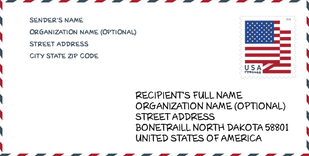
Envelope Example

This is an example of a US zip envelope. You can use a 5-digit zipcode or a detailed 9-digit zipcode to copy the mail in the following address format.
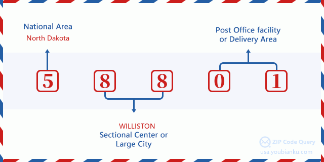
58801 Basic Meaning
What does each digit of ZIP Code 58801 stands for? The first digit designates a national area, which ranges from zero for the Northeast to nine for the far West. The 2-3 digits are the code of a sectional center facility in that region. The last two digits designate small post offices or postal zones.
Online Map

This is online map of the address Williston, North Dakota, United States. You may use button to move and zoom in / out. The map information is for reference only.
University

This is the ZIP Code 58801 - University page list. Its detail university Name, Street, City, State, ZIP Code, Phone is as below.
| Name | Street | City | State | ZIP Code | Phone |
| Williston State College | 1410 University Avenue | Williston | ND | 58801 | (701) 774-4200 |
Hospital

This is the ZIP Code 58801 - Hospital page list. Its detail Hospital Name, Street, City, State, ZIP Code, Phone is as below.
- Name: CHI ST ALEXIUS HEALTH WILLISTON
- Address: WILLISTON
- City: 1301 15TH AVE W
- State: ND
- ZIP Code: 58801
- Phone: (701) 774-7400
Museum

This is the ZIP Code 58801 - Museum page list. Its detail Museum Name, Street, City, State, ZIP Code, Phone is as below.
| Name | Street | City | State | ZIP Code | Phone |
| FORT BUFORD STATE HISTORIC SITE | 15349 39TH LN NW | WILLISTON | ND | 58801 | (701) 572-9034 |
| FRONTIER MUSEUM | 212 AIRPORT ROAD | WILLISTON | ND | 58801 | (701) 580-2415 |
| PIONEER TRAILS HISTORICAL SOCIETY | 2310 UNIVERSITY AVENUE | WILLISTON | ND | 58801 | |
| FORT UNION AND FORT BUFORD | 417 1ST STREET EAST | WILLISTON | ND | 58801 | (701) 572-8296 |
| MISSOURI-YELLOWSTONE CONFLUENCE INTERPRETIVE CENTER | 15349 39TH LANE NW | WILLISTON | ND | 58801 | (701) 572-9034 |
| WILLIAMS COUNTY HISTORICAL SOCIETY | PO BOX 285 | WILLISTON | ND | 58801 |
Library

This is the ZIP Code 58801 - Library page list. Its detail Library Name, Address, City, State, ZIP Code, Phone is as below.
| Name | Address | City | State | ZIP Code | Phone |
|---|---|---|---|---|---|
| WILLISTON COMMUNITY LIBRARY | 1302 DAVIDSON DRIVE | WILLISTON | ND | 58801 | (701) 774-8805 |
| WILLISTON COMMUNITY LIBRARY | 1302 DAVIDSON DRIVE | WILLISTON | ND | 58801 | -4 |
School
This is the ZIP Code 58801 - School page list. Its detail School Name, Address, City, State, ZIP Code is as below.
| School Name | Address | City | State | Grades | ZIP Code |
|---|---|---|---|---|---|
| HAGAN ELEMENTARY SCHOOL | 2501 29th Street | WILLISTON | ND | UG | 58801 |
| LEWIS AND CLARK ELEMENTARY SCHOOL | 704 17TH AVE W | WILLISTON | ND | UG | 58801 |
| RICKARD ELEMENTARY SCHOOL | 1224 1ST AVE E | WILLISTON | ND | UG | 58801 |
| WILKINSON ELEMENTARY SCHOOL | 1200 9th Ave NW | WILLISTON | ND | UG | 58801 |
| MCVAY ELEMENTARY SCHOOL | 420 UNIVERSITY AVE | WILLISTON | ND | UG | 58801 |
| ASB INNOVATION ACADEMY | 1204 4TH AVE W | WILLISTON | ND | UG | 58801 |
| WILLISTON MIDDLE SCHOOL | 501 14 St West | WILLISTON | ND | UG | 58801 |
| BAKKEN ELEMENTARY SCHOOL | 502 West Highland Dr | WILLISTON | ND | UG | 58801 |
| DEL EASTON ALTERNATIVE HIGH SCHOOL | 2304 11TH AVE W | WILLISTON | ND | UG | 58801 |
| ROUND PRAIRIE ELEMENTARY SCHOOL | 5098 151ST AVE NW | WILLISTON | ND | UG | 58801 |
| GARDEN VALLEY ELEMENTARY SCHOOL | 13565 60th Street NW | WILLISTON | ND | UG | 58801 |
| MISSOURI RIDGE MIDDLE SCHOOL | 5640 140th Avenue NW | WILLISTON | ND | UG | 58801 |
Population for ZIP Code 58801

What is the total population in ZIP Code 58801? Below is detail information.
- Population for ZIP Code 58801: 36,296
- 2010 Population: 18,371
The 2020 demographic statistics are in progress. The current population in ZIP code 58801 is 36,296, and the population in 2010 is 18,371.
Gender

In all the statistical population, the male population is 9,435, the female population is 8,936.
- Male Population: 9,435
- Female Population: 8,936
Race

In all the statistical population, the male population is 9,435, the female population is 8,936.
- White Population: 17,483
- Black Population: 114
- Hispanic Population: 364
- Asian Population: 113
- Hawaiian Population: 19
- Indian Population: 1,124
- Other Population: 94
Age

In all the statistical population, the White population is 17,483, the Black population is 114, the Hispanic population is 364, the Asian population is 113, the Hawaiian population is 19, the Indian Ppopulation is 1,124 and Other population is 94.
- Age's Median: 37.0
- Median of male age: 35.4
- Median of female age: 39.1
Households for ZIP Code 58801
ZIP code 58801 has 7,549 households, with an average number of 2.37 persons per household. The average income per household in Zip code 58801 is 87,934 USD, and the average house value is 260,500 USD.
- Households Per Zipcode: 7,549
- Persons Per Household: 2.37
- Average House Value: 260,500
- Income Per Household: 87,934
Housing Unit

In ZIP code 58801, the growth rank of housing unit is 3, the number of housing unit was 22,398 in 2010 and increased to 24,374 in 2011, the growth increase number is 1,976, the growth increase percentage is 8.8%.
- Growth Rank: 3
- Housing Units Estimate in 2010: 22,398
- Housing Units Estimate in 2011: 24,374
- Growth Increase Number: 1,976
- Growth Increase Percentage: 8.8%
Geographic

The latitude of the Zip code 58801 is 48.209139, the longitude is -103.661174, and the elevation is 2041. It has land area of 831.769 square miles, and water area of 35.04 square miles. The time zone for ZIP code 58801 is Central (GMT -06:00). Daylight saving time should be observed in the area where the zip code is located.
- Latitude: 48.209139
- Longitude: -103.661174
- Elevation: 2041
- Land Area: 831.769
- Water Area: 35.04
- Time Zone: Central (GMT -06:00)
- Region: Midwest
- Division: West North Central
- Day Light Saving: Y
Delivery

In the ZIP code 58801, there are 15,315 residential delivery mailboxes and centralized units, and 956 commercial delivery mailbox and centralized units, 4,954 single family deliveries and 2,681 multifamily deliveries, and the box count is 16,085. The main post office has city delivery carrier routes for the ZIP code 58801.
- Delivery Residential: 15,315
- Delivery Business: 956
- Delivery Total: 16,085
- Single Family Delivery Units: 4,954
- Multi Family Delivery Units: 2,681
- City Delivery Indicator: Y
Business

In ZIP code 58801, the number of business is 1,235, the number of employee is 17,742, the business first quarter payroll is 298,977,000 USD, the business annual payroll is 1,273,091,000 USD.
- Number Of Businesses: 1,235
- Number Of Employees: 17,742
- Business First Quarter Payroll: 298,977,000
- Business Annual Payroll: 1,273,091,000
Social Security Benefits

There are 2,725 beneficiaries with benefits in current-payment status for ZIP code 58801, of which 1,880 are retired workers, 345 are disabled workers, 195 are widow(er)s and parents, 70 are spouses and 235 are children. The number of beneficiaries aged 65 or older is 2,025. The total monthly benefits are 3,811,000 USD, of which 2,856,000 USD for retired workers, 280,000 USD for widow(er)s and parents.
- Total Number: 2,725
- Retired workers Number: 1,880
- Disabled workers Number: 345
- Widow(er)s and parents Number: 195
- Spouses Number: 70
- Children Number: 235
- All beneficiaries per month: 3,811,000
- Retired workers per month: 2,856,000
- Widow(er)s and parents per month: 280,000
- Number of beneficiaries aged 65 or older: 2,025


Add new comment