United States ZIP Code: 67550
This is the Kansas ZIP Code 67550 page list. Its detail State, County, City, Longitude, Latitude, Envelope Example, Population is as below.

ZIP Code 67550 Information

-
-
Country:
U.S. - United States
State:
State FIPS:
20
Area Code:
ZIP Code:
67550
ZIP Type:
S (Standard)
❓What does S (Standard) mean? A "standard" ZIP Code is what most people think of when they talk about ZIP Codes - essentially a town, city, or a division of a city that has mail service.
-


-
Iconic US Landmark Legacy Designs
Get PNG, SVG, EPS, AI, PDF Versions at Just $0.1
 Download Now
-


ZipCodeCraft
ZIP Code 67550 - City

This is the city information corresponding to 67550:
| State | County | City | City Type ?In many cases, a ZIP Code can have multiple "names", meaning cities, towns, or subdivisions, in its boundaries. However, it will ALWAYS have exactly 1 "default" name. D - Default - This is the "preferred" name - by the USPS - for a city. Each ZIP Code has one - and only one - "default" name. In most cases, this is what people who live in that area call the city as well. A - Acceptable - This name can be used for mailing purposes. Often times alternative names are large neighborhoods or sections of the city/town. In some cases a ZIP Code may have several "acceptable" names which is used to group towns under one ZIP Code. N - Not Acceptable - A "not acceptable" name is, in many cases, a nickname that residents give that location. According to the USPS, you should NOT send mail to that ZIP Code using the "not acceptable" name when mailing. | ZIP Code |
|---|---|---|---|---|
| KS | Pawnee | Fort Larned National History | N (Not Acceptable) | 67550 |
| KS | Pawnee | Larned | D (Default) | 67550 |
| KS | Pawnee | Radium | A (Acceptable) | 67550 |
❓What does D (Default) mean? This is the "preferred" name - by the USPS - for a city. Each ZIP Code has one - and only one - "default" name. In most cases, this is what people who live in that area call the city as well.
❓What does A (Acceptable) mean? This name can be used for mailing purposes. Often times alternative names are large neighborhoods or sections of the city/town. In some cases a ZIP Code may have several "acceptable" names which is used to group towns under one ZIP Code.
❓What does N (Not Acceptable) mean? A "not acceptable" name is, in many cases, a nickname that residents give that location. According to the USPS, you should NOT send mail to that ZIP Code using the "not acceptable" name when mailing.
ZIP Code 67550 Plus 4
ZIP Code 5 plus 4 is the extension of 5-digit zip code, It can be used to locate a more detailed location. The last four digits designate segment or one side of a street or an apartment. You can find the ZIP+4 code and corresponding address of the zip code 67550 below.
| ZIP Code 5 Plus 4 | Address |
|---|---|
| 67550-0001 | PO BOX 1, LARNED, KS |
| 67550-0061 | PO BOX 61, LARNED, KS |
| 67550-0141 | PO BOX 141, LARNED, KS |
| 67550-0160 | PO BOX 0, LARNED, KS |
| 67550-0161 | PO BOX 161, LARNED, KS |
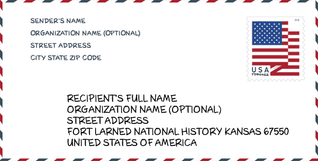
Envelope Example

This is an example of a US zip envelope. You can use a 5-digit zipcode or a detailed 9-digit zipcode to copy the mail in the following address format.
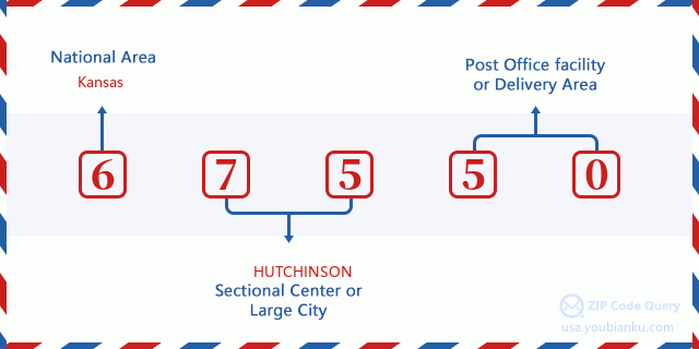
67550 Basic Meaning
What does each digit of ZIP Code 67550 stands for? The first digit designates a national area, which ranges from zero for the Northeast to nine for the far West. The 2-3 digits are the code of a sectional center facility in that region. The last two digits designate small post offices or postal zones.
Online Map

This is online map of the address Radium, Kansas, United States. You may use button to move and zoom in / out. The map information is for reference only.
Hospital

This is the ZIP Code 67550 - Hospital page list. Its detail Hospital Name, Street, City, State, ZIP Code, Phone is as below.
| Name | Address | City | State | ZIP Code | Phone |
|---|---|---|---|---|---|
| PAWNEE VALLEY COMMUNITY HOSPITAL | 923 CARROLL AVENUE | LARNED | KS | 67550 | (620) 285-3162 |
| LARNED STATE HOSPITAL | 1301 KS HIGHWAY 264 | LARNED | KS | 67550 | (620) 285-4360 |
Museum

This is the ZIP Code 67550 - Museum page list. Its detail Museum Name, Street, City, State, ZIP Code, Phone is as below.
| Name | Street | City | State | ZIP Code | Phone |
| SANTA FE TRAIL CENTER | RT 3 BOX 137 | LARNED | KS | 67550 | (620) 285-2054 |
| CENTRAL STATES SCOUT MUSEUM | 815 BROADWAY ST | LARNED | KS | 67550 | (620) 285-6427 |
| FORT LARNED NATIONAL HISTORIC SITE | 1767 KANSAS HWY 156 | LARNED | KS | 67550 | (620) 285-6911 |
Library

This is the ZIP Code 67550 - Library page list. Its detail Library Name, Address, City, State, ZIP Code, Phone is as below.
- Name: JORDAAN MEMORIAL LIBRARY
- Address: 724 BROADWAY
- City: LARNED
- State: KS - Kansas
- ZIP Code: 67550
- Phone: (620) 285-2876
School

This is the ZIP Code 67550 - School page list. Its detail School Name, Address, City, State, ZIP Code is as below.
| School Name | Address | City | State | Grades | ZIP Code |
|---|---|---|---|---|---|
| Larned Middle School | 904 Corse | Larned | KS | UG | 67550 |
| Larned Sr High | 815 Corse | Larned | KS | UG | 67550 |
| Fort Larned Elementary School | 2104 Broadway | Larned | KS | UG | 67550 |
Population for ZIP Code 67550

What is the total population in ZIP Code 67550? Below is detail information.
- Population for ZIP Code 67550: 4,647
- 2010 Population: 5,905
The 2020 demographic statistics are in progress. The current population in ZIP code 67550 is 4,647, and the population in 2010 is 5,905.
Gender

In all the statistical population, the male population is 3,325, the female population is 2,580.
- Male Population: 3,325
- Female Population: 2,580
Race

In all the statistical population, the male population is 3,325, the female population is 2,580.
- White Population: 5,401
- Black Population: 384
- Hispanic Population: 420
- Asian Population: 45
- Hawaiian Population: 10
- Indian Population: 79
- Other Population: 116
Age

In all the statistical population, the White population is 5,401, the Black population is 384, the Hispanic population is 420, the Asian population is 45, the Hawaiian population is 10, the Indian Ppopulation is 79 and Other population is 116.
- Age's Median: 42.2
- Median of male age: 39.8
- Median of female age: 46.0
Households for ZIP Code 67550
ZIP code 67550 has 2,209 households, with an average number of 2.21 persons per household. The average income per household in Zip code 67550 is 42,143 USD, and the average house value is 79,000 USD.
- Households Per Zipcode: 2,209
- Persons Per Household: 2.21
- Average House Value: 79,000
- Income Per Household: 42,143
Geographic

The latitude of the Zip code 67550 is 38.175195, the longitude is -99.241170, and the elevation is 2042. It has land area of 315.929 square miles, and water area of 0.164 square miles. The time zone for ZIP code 67550 is Central (GMT -06:00). Daylight saving time should be observed in the area where the zip code is located.
- Latitude: 38.175195
- Longitude: -99.241170
- Elevation: 2042
- Land Area: 315.929
- Water Area: 0.164
- Time Zone: Central (GMT -06:00)
- Region: Midwest
- Division: West North Central
- Day Light Saving: Y
Congressional District

The Congressional District for ZIP code 67550 is Kansas's 1st|04th congressional district, the Congressional Land Area is 52542.5|14315.68 square mile.
- Congressional District: 1st|04th
- Congressional Land Area: 52542.5|14315.68
Delivery

In the ZIP code 67550, there are 2,103 residential delivery mailboxes and centralized units, and 150 commercial delivery mailbox and centralized units, 1,954 single family deliveries and 77 multifamily deliveries, and the box count is 2,481. The main post office has city delivery carrier routes for the ZIP code 67550.
- Delivery Residential: 2,103
- Delivery Business: 150
- Delivery Total: 2,481
- Single Family Delivery Units: 1,954
- Multi Family Delivery Units: 77
- City Delivery Indicator: Y
Business

In ZIP code 67550, the number of business is 131, the number of employee is 1,891, the business first quarter payroll is 17,276,000 USD, the business annual payroll is 72,241,000 USD.
- Number Of Businesses: 131
- Number Of Employees: 1,891
- Business First Quarter Payroll: 17,276,000
- Business Annual Payroll: 72,241,000
Social Security Benefits

There are 1,255 beneficiaries with benefits in current-payment status for ZIP code 67550, of which 890 are retired workers, 165 are disabled workers, 90 are widow(er)s and parents, 30 are spouses and 80 are children. The number of beneficiaries aged 65 or older is 960. The total monthly benefits are 1,699,000 USD, of which 1,293,000 USD for retired workers, 125,000 USD for widow(er)s and parents.
- Total Number: 1,255
- Retired workers Number: 890
- Disabled workers Number: 165
- Widow(er)s and parents Number: 90
- Spouses Number: 30
- Children Number: 80
- All beneficiaries per month: 1,699,000
- Retired workers per month: 1,293,000
- Widow(er)s and parents per month: 125,000
- Number of beneficiaries aged 65 or older: 960


Add new comment