ZIP Code: 80538, Loveland, CO
ZIP Code 80538 is located in Loveland, Colorado. Its detail State, County, City, Longitude, Latitude, Envelope Example, Population is as below.
ZIP Code 80538 Information

-
-
Country:
U.S. - United States
State:
County FIPS:
08069
County:
City:
Area Code:
City Type ?In many cases, a ZIP Code can have multiple "names", meaning cities, towns, or subdivisions, in its boundaries. However, it will ALWAYS have exactly 1 "default" name. D - Default - This is the "preferred" name - by the USPS - for a city. Each ZIP Code has one - and only one - "default" name. In most cases, this is what people who live in that area call the city as well. A - Acceptable - This name can be used for mailing purposes. Often times alternative names are large neighborhoods or sections of the city/town. In some cases a ZIP Code may have several "acceptable" names which is used to group towns under one ZIP Code. N - Not Acceptable - A "not acceptable" name is, in many cases, a nickname that residents give that location. According to the USPS, you should NOT send mail to that ZIP Code using the "not acceptable" name when mailing.:
D (Default)
ZIP Code:
80538
❓What does D (Default) mean? This is the "preferred" name - by the USPS - for a city. Each ZIP Code has one - and only one - "default" name. In most cases, this is what people who live in that area call the city as well.
-


-
Iconic US Landmark Legacy Designs
Get PNG, SVG, EPS, AI, PDF Versions at Just $0.1
 Download Now
-


ZipCodeCraft
ZIP Code 80538 Plus 4
ZIP Code 5 plus 4 is the extension of 5-digit zip code, It can be used to locate a more detailed location. The last four digits designate segment or one side of a street or an apartment. You can find the ZIP+4 code and corresponding address of the zip code 80538 below.
| ZIP Code 5 Plus 4 | Address |
|---|---|
| 80538-1000 | 5300 SPRING GLADE RD, LOVELAND, CO |
| 80538-1002 | 5101 RIDGE PKWY, LOVELAND, CO |
| 80538-1003 | 3700 W 57TH ST, LOVELAND, CO |
| 80538-1004 | 1401 W 57TH ST, LOVELAND, CO |
| 80538-1014 | 5300 RAIN SHADOW LN, LOVELAND, CO |
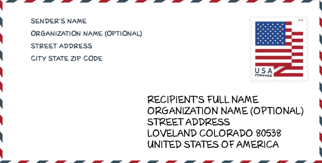
Envelope Example

This is an example of a US zip envelope. You can use a 5-digit zipcode or a detailed 9-digit zipcode to copy the mail in the following address format.
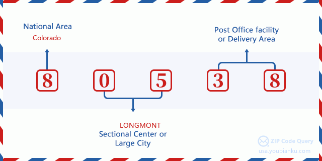
80538 Basic Meaning
What does each digit of ZIP Code 80538 stands for? The first digit designates a national area, which ranges from zero for the Northeast to nine for the far West. The 2-3 digits are the code of a sectional center facility in that region. The last two digits designate small post offices or postal zones.
Online Map

This is online map of the address Loveland, Colorado, United States. You may use button to move and zoom in / out. The map information is for reference only.
University

This is the ZIP Code 80538 - University page list. Its detail university Name, Street, City, State, ZIP Code, Phone is as below.
| Name | Street | City | State | ZIP Code | Phone |
| Cheeks International Academy of Beauty Culture-Fort Collins | 5010 Granite Street | Loveland | CO | 80538 | - |
| Cheeks Beauty Academy | 5010 Granite Street | Loveland | CO | 80538 | (970) 667-4122 |
Hospital

This is the ZIP Code 80538 - Hospital page list. Its detail Hospital Name, Street, City, State, ZIP Code, Phone is as below.
| Name | Address | City | State | ZIP Code | Phone |
|---|---|---|---|---|---|
| MCKEE MEDICAL CENTER | 2000 BOISE AVE | LOVELAND | CO | 80538 | (970) 669-4640 |
| MEDICAL CENTER OF THE ROCKIES | 2500 ROCKY MOUNTAIN AVENUE | LOVELAND | CO | 80538 | (970) 624-2500 |
Museum

This is the ZIP Code 80538 - Museum page list. Its detail Museum Name, Street, City, State, ZIP Code, Phone is as below.
- Name: HIGH PLAINS ENVIRONMENTAL CENTER
- Street: 1854 PINEY RIVER DRIVE
- City: LOVELAND
- State: CO
- ZIP Code: 80538
- Phone: (970) 622-9676
School
This is the ZIP Code 80538 - School page list. Its detail School Name, Address, City, State, ZIP Code is as below.
| School Name | Address | City | State | Grades | ZIP Code |
|---|---|---|---|---|---|
| Bamford Elementary School | 6055 TRAVERS STAKES STREET | LOVELAND | CO | UG | 80538 |
| Harold Ferguson High School | 1811 W 15TH ST | LOVELAND | CO | UG | 80538 |
| Thompson Integrated Early Childhood | 407 EAST 42ND STREET | LOVELAND | CO | UG | 80538 |
| LEAP School | 2525 VAN BUREN CT | LOVELAND | CO | UG | 80538 |
Population for ZIP Code 80538

What is the total population in ZIP Code 80538? Below is detail information.
- Population for ZIP Code 80538: 52,124
- 2010 Population: 43,930
The 2020 demographic statistics are in progress. The current population in ZIP code 80538 is 52,124, and the population in 2010 is 43,930.
Gender

In all the statistical population, the male population is 21,128, the female population is 22,802.
- Male Population: 21,128
- Female Population: 22,802
Race

In all the statistical population, the male population is 21,128, the female population is 22,802.
- White Population: 41,427
- Black Population: 390
- Hispanic Population: 4,605
- Asian Population: 694
- Hawaiian Population: 60
- Indian Population: 613
- Other Population: 1,821
Age

In all the statistical population, the White population is 41,427, the Black population is 390, the Hispanic population is 4,605, the Asian population is 694, the Hawaiian population is 60, the Indian Ppopulation is 613 and Other population is 1,821.
- Age's Median: 40.6
- Median of male age: 39.1
- Median of female age: 41.9
Households for ZIP Code 80538
ZIP code 80538 has 17,581 households, with an average number of 2.48 persons per household. The average income per household in Zip code 80538 is 68,031 USD, and the average house value is 294,100 USD.
- Households Per Zipcode: 17,581
- Persons Per Household: 2.48
- Average House Value: 294,100
- Income Per Household: 68,031
Geographic

The latitude of the Zip code 80538 is 40.503903, the longitude is -105.131245, and the elevation is 5267. It has land area of 108.023 square miles, and water area of 4.93 square miles. The time zone for ZIP code 80538 is Mountain (GMT -07:00). Daylight saving time should be observed in the area where the zip code is located.
- Latitude: 40.503903
- Longitude: -105.131245
- Elevation: 5267
- Land Area: 108.023
- Water Area: 4.93
- Time Zone: Mountain (GMT -07:00)
- Region: West
- Division: Mountain
- Day Light Saving: Y
Congressional District

The Congressional District for ZIP code 80538 is Colorado's 2nd congressional district, the Congressional Land Area is 7535.34 square mile.
- Congressional District: 2nd
- Congressional Land Area: 7535.34
Delivery

In the ZIP code 80538, there are 21,018 residential delivery mailboxes and centralized units, and 1,223 commercial delivery mailbox and centralized units, 6,624 single family deliveries and 2,066 multifamily deliveries, and the box count is 30,627. The main post office has city delivery carrier routes for the ZIP code 80538.
- Delivery Residential: 21,018
- Delivery Business: 1,223
- Delivery Total: 30,627
- Single Family Delivery Units: 6,624
- Multi Family Delivery Units: 2,066
- City Delivery Indicator: Y
Business

In ZIP code 80538, the number of business is 1,413, the number of employee is 21,620, the business first quarter payroll is 237,690,000 USD, the business annual payroll is 984,960,000 USD.
- Number Of Businesses: 1,413
- Number Of Employees: 21,620
- Business First Quarter Payroll: 237,690,000
- Business Annual Payroll: 984,960,000
Social Security Benefits

There are 10,990 beneficiaries with benefits in current-payment status for ZIP code 80538, of which 8,550 are retired workers, 910 are disabled workers, 660 are widow(er)s and parents, 475 are spouses and 395 are children. The number of beneficiaries aged 65 or older is 9,190. The total monthly benefits are 16,128,000 USD, of which 13,191,000 USD for retired workers, 981,000 USD for widow(er)s and parents.
- Total Number: 10,990
- Retired workers Number: 8,550
- Disabled workers Number: 910
- Widow(er)s and parents Number: 660
- Spouses Number: 475
- Children Number: 395
- All beneficiaries per month: 16,128,000
- Retired workers per month: 13,191,000
- Widow(er)s and parents per month: 981,000
- Number of beneficiaries aged 65 or older: 9,190


Add new comment