ZIP Code: 85202, Mesa, AZ
ZIP Code 85202 is located in Mesa, Arizona. Its detail State, County, City, Longitude, Latitude, Envelope Example, Population is as below.
ZIP Code 85202 Information

-
-
Country:
U.S. - United States
State:
County FIPS:
04013
County:
City:
City Type ?In many cases, a ZIP Code can have multiple "names", meaning cities, towns, or subdivisions, in its boundaries. However, it will ALWAYS have exactly 1 "default" name. D - Default - This is the "preferred" name - by the USPS - for a city. Each ZIP Code has one - and only one - "default" name. In most cases, this is what people who live in that area call the city as well. A - Acceptable - This name can be used for mailing purposes. Often times alternative names are large neighborhoods or sections of the city/town. In some cases a ZIP Code may have several "acceptable" names which is used to group towns under one ZIP Code. N - Not Acceptable - A "not acceptable" name is, in many cases, a nickname that residents give that location. According to the USPS, you should NOT send mail to that ZIP Code using the "not acceptable" name when mailing.:
D (Default)
ZIP Code:
85202
❓What does D (Default) mean? This is the "preferred" name - by the USPS - for a city. Each ZIP Code has one - and only one - "default" name. In most cases, this is what people who live in that area call the city as well.
-


-
Iconic US Landmark Legacy Designs
Get PNG, SVG, EPS, AI, PDF Versions at Just $0.1
 Download Now
-


ZipCodeCraft
ZIP Code 85202 Plus 4
ZIP Code 5 plus 4 is the extension of 5-digit zip code, It can be used to locate a more detailed location. The last four digits designate segment or one side of a street or an apartment. You can find the ZIP+4 code and corresponding address of the zip code 85202 below.
| ZIP Code 5 Plus 4 | Address |
|---|---|
| 85202-1000 | 100 S ROOSEVELT RD, MESA, AZ |
| 85202-1001 | 2001 W BROADWAY RD, MESA, AZ |
| 85202-1002 | 2101 W BROADWAY RD, MESA, AZ |
| 85202-1003 | 2201 W BROADWAY RD, MESA, AZ |
| 85202-1005 | 2301 W BROADWAY RD, MESA, AZ |
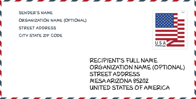
Envelope Example

This is an example of a US zip envelope. You can use a 5-digit zipcode or a detailed 9-digit zipcode to copy the mail in the following address format.
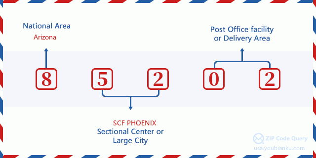
85202 Basic Meaning
What does each digit of ZIP Code 85202 stands for? The first digit designates a national area, which ranges from zero for the Northeast to nine for the far West. The 2-3 digits are the code of a sectional center facility in that region. The last two digits designate small post offices or postal zones.
Online Map

This is online map of the address Mesa, Arizona, United States. You may use button to move and zoom in / out. The map information is for reference only.
University

This is the ZIP Code 85202 - University page list. Its detail university Name, Street, City, State, ZIP Code, Phone is as below.
| Name | Street | City | State | ZIP Code | Phone |
| Mesa Community College | 1833 W Southern Ave | Mesa | AZ | 85202 | (480) 461-7000 |
| Pima Medical Institute-Mesa | 957 S. Dobson Road | Mesa | AZ | 85202 | (480) 644-0267 |
| Regency Beauty Institute-Mesa | 1457 West Southern Ave, Suite 113 | Mesa | AZ | 85202 | - |
| United Education Institute-UEI College-Mesa | 1420 W. Southern Avenue, Suite D | Mesa | AZ | 85202 | (408) 885-8901 |
Hospital

This is the ZIP Code 85202 - Hospital page list. Its detail Hospital Name, Street, City, State, ZIP Code, Phone is as below.
- Name: BANNER DESERT MEDICAL CENTER
- Address: MESA
- City: 1400 SOUTH DOBSON ROAD
- State: AZ
- ZIP Code: 85202
- Phone: (480) 412-3000
Library

This is the ZIP Code 85202 - Library page list. Its detail Library Name, Address, City, State, ZIP Code, Phone is as below.
- Name: DOBSON RANCH LIBRARY
- Address: 2425 S DOBSON RD
- City: MESA
- State: AZ - Arizona
- ZIP Code: 85202
- Phone: (480) 644-3100
School
This is the ZIP Code 85202 - School page list. Its detail School Name, Address, City, State, ZIP Code is as below.
| School Name | Address | City | State | Grades | ZIP Code |
|---|---|---|---|---|---|
| AAEC Online | 1440 S Longhorn | Mesa | AZ | 09-12 | 85202 |
| Franklin at Alma Elementary | 1313 W. Medina Ave | Mesa | AZ | PK-08 | 85202 |
Population for ZIP Code 85202

What is the total population in ZIP Code 85202? Below is detail information.
- Population for ZIP Code 85202: 40,045
- 2010 Population: 37,275
The 2020 demographic statistics are in progress. The current population in ZIP code 85202 is 40,045, and the population in 2010 is 37,275.
Gender

In all the statistical population, the male population is 18,547, the female population is 18,728.
- Male Population: 18,547
- Female Population: 18,728
Race

In all the statistical population, the male population is 18,547, the female population is 18,728.
- White Population: 26,731
- Black Population: 2,965
- Hispanic Population: 10,030
- Asian Population: 1,591
- Hawaiian Population: 314
- Indian Population: 2,285
- Other Population: 5,101
Age

In all the statistical population, the White population is 26,731, the Black population is 2,965, the Hispanic population is 10,030, the Asian population is 1,591, the Hawaiian population is 314, the Indian Ppopulation is 2,285 and Other population is 5,101.
- Age's Median: 31.5
- Median of male age: 30.7
- Median of female age: 32.3
Households for ZIP Code 85202
ZIP code 85202 has 15,628 households, with an average number of 2.38 persons per household. The average income per household in Zip code 85202 is 48,465 USD, and the average house value is 214,400 USD.
- Households Per Zipcode: 15,628
- Persons Per Household: 2.38
- Average House Value: 214,400
- Income Per Household: 48,465
Geographic

The latitude of the Zip code 85202 is 33.385764, the longitude is -111.875586, and the elevation is 1201. It has land area of 6.289 square miles, and water area of 0.124 square miles. The time zone for ZIP code 85202 is Mountain (GMT -07:00). Daylight saving time should be observed in the area where the zip code is located.
- Latitude: 33.385764
- Longitude: -111.875586
- Elevation: 1201
- Land Area: 6.289
- Water Area: 0.124
- Time Zone: Mountain (GMT -07:00)
- Region: West
- Division: Mountain
- Day Light Saving: N
Congressional District

The Congressional District for ZIP code 85202 is Arizona's 09th congressional district, the Congressional Land Area is 164.79 square mile.
- Congressional District: 09th
- Congressional Land Area: 164.79
Delivery

In the ZIP code 85202, there are 16,826 residential delivery mailboxes and centralized units, and 946 commercial delivery mailbox and centralized units, 6,831 single family deliveries and 7,426 multifamily deliveries, and the box count is 19,870. The main post office has city delivery carrier routes for the ZIP code 85202.
- Delivery Residential: 16,826
- Delivery Business: 946
- Delivery Total: 19,870
- Single Family Delivery Units: 6,831
- Multi Family Delivery Units: 7,426
- City Delivery Indicator: Y
Business

In ZIP code 85202, the number of business is 883, the number of employee is 15,979, the business first quarter payroll is 168,753,000 USD, the business annual payroll is 676,150,000 USD.
- Number Of Businesses: 883
- Number Of Employees: 15,979
- Business First Quarter Payroll: 168,753,000
- Business Annual Payroll: 676,150,000
Social Security Benefits

There are 5,460 beneficiaries with benefits in current-payment status for ZIP code 85202, of which 3,950 are retired workers, 735 are disabled workers, 275 are widow(er)s and parents, 170 are spouses and 330 are children. The number of beneficiaries aged 65 or older is 4,200. The total monthly benefits are 8,061,000 USD, of which 6,294,000 USD for retired workers, 417,000 USD for widow(er)s and parents.
- Total Number: 5,460
- Retired workers Number: 3,950
- Disabled workers Number: 735
- Widow(er)s and parents Number: 275
- Spouses Number: 170
- Children Number: 330
- All beneficiaries per month: 8,061,000
- Retired workers per month: 6,294,000
- Widow(er)s and parents per month: 417,000
- Number of beneficiaries aged 65 or older: 4,200


Add new comment