United States ZIP Code: 87114
This is the New Mexico ZIP Code 87114 page list. Its detail State, County, City, Longitude, Latitude, Envelope Example, Population is as below.
, showcasing adobe houses, farmland, and Sandia Mountains, with a modern postal theme including vintage postcard layout and Albuquerque landmarks like the KiMo Theater, Occidental Life Building, and ZIP code 87114.")
ZIP Code 87114 Information

-
-
Country:
U.S. - United States
State:
State FIPS:
35
Area Code:
ZIP Code:
87114
ZIP Type:
S (Standard)
❓What does S (Standard) mean? A "standard" ZIP Code is what most people think of when they talk about ZIP Codes - essentially a town, city, or a division of a city that has mail service.
-


-
Iconic US Landmark Legacy Designs
Get PNG, SVG, EPS, AI, PDF Versions at Just $0.1
 Download Now
-


ZipCodeCraft
ZIP Code 87114 - City

This is the city information corresponding to 87114:
| State | County | City | City Type ?In many cases, a ZIP Code can have multiple "names", meaning cities, towns, or subdivisions, in its boundaries. However, it will ALWAYS have exactly 1 "default" name. D - Default - This is the "preferred" name - by the USPS - for a city. Each ZIP Code has one - and only one - "default" name. In most cases, this is what people who live in that area call the city as well. A - Acceptable - This name can be used for mailing purposes. Often times alternative names are large neighborhoods or sections of the city/town. In some cases a ZIP Code may have several "acceptable" names which is used to group towns under one ZIP Code. N - Not Acceptable - A "not acceptable" name is, in many cases, a nickname that residents give that location. According to the USPS, you should NOT send mail to that ZIP Code using the "not acceptable" name when mailing. | ZIP Code |
|---|---|---|---|---|
| NM | Bernalillo | Alameda | A (Acceptable) | 87114 |
| NM | Bernalillo | Albuquerque | D (Default) | 87114 |
| NM | Bernalillo | Los Ranchos | A (Acceptable) | 87114 |
| NM | Bernalillo | Los Ranchos De Abq | A (Acceptable) | 87114 |
| NM | Bernalillo | Los Ranchos De Albuquerque | A (Acceptable) | 87114 |
| NM | Bernalillo | Los Rnchs Abq | A (Acceptable) | 87114 |
| NM | Bernalillo | Village Of Los Ranchos | A (Acceptable) | 87114 |
❓What does D (Default) mean? This is the "preferred" name - by the USPS - for a city. Each ZIP Code has one - and only one - "default" name. In most cases, this is what people who live in that area call the city as well.
❓What does A (Acceptable) mean? This name can be used for mailing purposes. Often times alternative names are large neighborhoods or sections of the city/town. In some cases a ZIP Code may have several "acceptable" names which is used to group towns under one ZIP Code.
ZIP Code 87114 Plus 4
ZIP Code 5 plus 4 is the extension of 5-digit zip code, It can be used to locate a more detailed location. The last four digits designate segment or one side of a street or an apartment. You can find the ZIP+4 code and corresponding address of the zip code 87114 below.
| ZIP Code 5 Plus 4 | Address |
|---|---|
| 87114-0001 | 150001 DONERRIE DR, ALBUQUERQUE, NM |
| 87114-0700 | 4487 IRVING BLVD #C , ALBUQUERQUE, NM |
| 87114-0701 | 4100 NEW VISTAS CT, ALBUQUERQUE, NM |
| 87114-0702 | 4101 NEW VISTAS CT, ALBUQUERQUE, NM |
| 87114-0703 | 4201 NEW VISTAS CT, ALBUQUERQUE, NM |
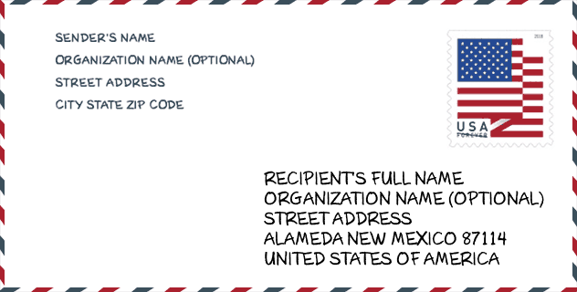
Envelope Example

This is an example of a US zip envelope. You can use a 5-digit zipcode or a detailed 9-digit zipcode to copy the mail in the following address format.
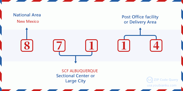
87114 Basic Meaning
What does each digit of ZIP Code 87114 stands for? The first digit designates a national area, which ranges from zero for the Northeast to nine for the far West. The 2-3 digits are the code of a sectional center facility in that region. The last two digits designate small post offices or postal zones.
Online Map

This is online map of the address Village Of Los Ranchos, New Mexico, United States. You may use button to move and zoom in / out. The map information is for reference only.
University

This is the ZIP Code 87114 - University page list. Its detail university Name, Street, City, State, ZIP Code, Phone is as below.
| Name | Street | City | State | ZIP Code | Phone |
| Pima Medical Institute-Albuquerque West | 8601 Golf Course Road NW | Albuquerque | NM | 87114 | (505) 890-4316 |
Hospital

This is the ZIP Code 87114 - Hospital page list. Its detail Hospital Name, Street, City, State, ZIP Code, Phone is as below.
- Name: LOVELACE WESTSIDE HOSPITAL
- Address: ALBUQUERQUE
- City: 10501 GOLF COURSE ROAD NW
- State: NM
- ZIP Code: 87114
- Phone: (505) 727-2001
Museum

This is the ZIP Code 87114 - Museum page list. Its detail Museum Name, Street, City, State, ZIP Code, Phone is as below.
| Name | Street | City | State | ZIP Code | Phone |
| J AND R VINTAGE AUTO MUSEUM | 3650 STATE HIGHWAY 528 NW | ALBUQUERQUE | NM | 87114 | (505) 867-2881 |
| POTATO MUSEUM | 9908 LA PAZ NW | ALBUQUERQUE | NM | 87114 | (505) 401-8922 |
School
This is the ZIP Code 87114 - School page list. Its detail School Name, Address, City, State, ZIP Code is as below.
| School Name | Address | City | State | Grades | ZIP Code |
|---|---|---|---|---|---|
| ALAMEDA ELEMENTARY | 412 ALAMEDA BLVD NW | ALBUQUERQUE | NM | UG | 87114 |
| CIBOLA HIGH | 1510 ELLISON DR NW | ALBUQUERQUE | NM | UG | 87114 |
| PETROGLYPH ELEMENTARY | 5100 MARNA LYNN AVE NW | ALBUQUERQUE | NM | UG | 87114 |
| SIERRA VISTA ELEMENTARY | 10220 PASEO DEL NORTE NW | ALBUQUERQUE | NM | UG | 87114 |
| TAYLOR MIDDLE | 8200 GUADALUPE TR NW | LOS RANCHOS DE ALBUQUERQUE | NM | UG | 87114 |
| SEVEN BAR ELEMENTARY | 4501 SEVEN BAR LOOP NW | ALBUQUERQUE | NM | UG | 87114 |
| JAMES MONROE MIDDLE | 6100 PARADISE BLVD NW | ALBUQUERQUE | NM | UG | 87114 |
| VENTANA RANCH ELEMENTARY | 6801 VENTANA VILLAGE RD NW | ALBUQUERQUE | NM | UG | 87114 |
| VOLCANO VISTA HIGH | 8100 RAINBOW RD NW | ALBUQUERQUE | NM | UG | 87114 |
| TIERRA ANTIGUA ELEMENTARY | 8121 RAINBOW BLVD NW | ALBUQUERQUE | NM | UG | 87114 |
| SUNSET VIEW ELEMENTARY | 6121 PARADISE BLVD NW | ALBUQUERQUE | NM | UG | 87114 |
| TONY HILLERMAN MIDDLE SCHOOL | 8101 RAINBOW BLVD NW | ALBUQUERQUE | NM | UG | 87114 |
| COYOTE WILLOW FAMILY SCHOOL | 7125 IRVING BLVD NW | ALBUQUERQUE | NM | UG | 87114 |
| NORTH VALLEY ACADEMY | 7939 4TH STREET NW | LOS RANCHOS DE ALBUQUERQUE | NM | UG | 87114 |
Population for ZIP Code 87114

What is the total population in ZIP Code 87114? Below is detail information.
- Population for ZIP Code 87114: 72,297
- 2010 Population: 61,623
The 2020 demographic statistics are in progress. The current population in ZIP code 87114 is 72,297, and the population in 2010 is 61,623.
Gender

In all the statistical population, the male population is 29,766, the female population is 31,857.
- Male Population: 29,766
- Female Population: 31,857
Race

In all the statistical population, the male population is 29,766, the female population is 31,857.
- White Population: 47,583
- Black Population: 2,832
- Hispanic Population: 27,087
- Asian Population: 2,076
- Hawaiian Population: 202
- Indian Population: 3,509
- Other Population: 8,883
Age

In all the statistical population, the White population is 47,583, the Black population is 2,832, the Hispanic population is 27,087, the Asian population is 2,076, the Hawaiian population is 202, the Indian Ppopulation is 3,509 and Other population is 8,883.
- Age's Median: 33.2
- Median of male age: 32.4
- Median of female age: 34.0
Households for ZIP Code 87114
ZIP code 87114 has 23,251 households, with an average number of 2.65 persons per household. The average income per household in Zip code 87114 is 67,142 USD, and the average house value is 212,200 USD.
- Households Per Zipcode: 23,251
- Persons Per Household: 2.65
- Average House Value: 212,200
- Income Per Household: 67,142
Geographic

The latitude of the Zip code 87114 is 35.125938, the longitude is -106.799894, and the elevation is 5815. It has land area of 21.206 square miles, and water area of 0.65 square miles. The time zone for ZIP code 87114 is Mountain (GMT -07:00). Daylight saving time should be observed in the area where the zip code is located.
- Latitude: 35.125938
- Longitude: -106.799894
- Elevation: 5815
- Land Area: 21.206
- Water Area: 0.65
- Time Zone: Mountain (GMT -07:00)
- Region: West
- Division: Mountain
- Day Light Saving: Y
Congressional District

The Congressional District for ZIP code 87114 is New Mexico's 1st|3rd congressional district, the Congressional Land Area is 4600.14|44958.52 square mile.
- Congressional District: 1st|3rd
- Congressional Land Area: 4600.14|44958.52
Delivery

In the ZIP code 87114, there are 27,282 residential delivery mailboxes and centralized units, and 1,008 commercial delivery mailbox and centralized units, 4,685 single family deliveries and 4,630 multifamily deliveries, and the box count is 32,705. The main post office has city delivery carrier routes for the ZIP code 87114.
- Delivery Residential: 27,282
- Delivery Business: 1,008
- Delivery Total: 32,705
- Single Family Delivery Units: 4,685
- Multi Family Delivery Units: 4,630
- City Delivery Indicator: Y
Business

In ZIP code 87114, the number of business is 980, the number of employee is 13,963, the business first quarter payroll is 99,215,000 USD, the business annual payroll is 421,876,000 USD.
- Number Of Businesses: 980
- Number Of Employees: 13,963
- Business First Quarter Payroll: 99,215,000
- Business Annual Payroll: 421,876,000
Social Security Benefits

There are 10,900 beneficiaries with benefits in current-payment status for ZIP code 87114, of which 7,640 are retired workers, 1,480 are disabled workers, 585 are widow(er)s and parents, 345 are spouses and 850 are children. The number of beneficiaries aged 65 or older is 8,035. The total monthly benefits are 15,446,000 USD, of which 11,701,000 USD for retired workers, 829,000 USD for widow(er)s and parents.
- Total Number: 10,900
- Retired workers Number: 7,640
- Disabled workers Number: 1,480
- Widow(er)s and parents Number: 585
- Spouses Number: 345
- Children Number: 850
- All beneficiaries per month: 15,446,000
- Retired workers per month: 11,701,000
- Widow(er)s and parents per month: 829,000
- Number of beneficiaries aged 65 or older: 8,035


Add new comment