United States ZIP Code: 90095
This is the California ZIP Code 90095 page list. Its detail State, County, City/Agency, Longitude, Latitude, Envelope Example, Population is as below.

ZIP Code 90095 Information

-
-
Country:
U.S. - United States
State:
State FIPS:
06
ZIP Code:
90095
ZIP Type:
U (Unique)
❓What does U (Unique) mean? Companies, organizations, and institutions that receive large quantities of mail are given a "unique" ZIP Code type.
-


-
Iconic US Landmark Legacy Designs
Get PNG, SVG, EPS, AI, PDF Versions at Just $0.1
 Download Now
-


ZipCodeCraft
ZIP Code 90095 - City/Agency

This is the city information corresponding to 90095:
| State | County | City/Agency | City Type ?In many cases, a ZIP Code can have multiple "names", meaning cities, towns, or subdivisions, in its boundaries. However, it will ALWAYS have exactly 1 "default" name. D - Default - This is the "preferred" name - by the USPS - for a city. Each ZIP Code has one - and only one - "default" name. In most cases, this is what people who live in that area call the city as well. A - Acceptable - This name can be used for mailing purposes. Often times alternative names are large neighborhoods or sections of the city/town. In some cases a ZIP Code may have several "acceptable" names which is used to group towns under one ZIP Code. N - Not Acceptable - A "not acceptable" name is, in many cases, a nickname that residents give that location. According to the USPS, you should NOT send mail to that ZIP Code using the "not acceptable" name when mailing. | ZIP Code |
|---|---|---|---|---|
| CA | Los Angeles | Los Angeles | D (Default) | 90095 |
| CA | Los Angeles | Uc Los Angeles | N (Not Acceptable) | 90095 |
❓What does D (Default) mean? This is the "preferred" name - by the USPS - for a city. Each ZIP Code has one - and only one - "default" name. In most cases, this is what people who live in that area call the city as well.
❓What does N (Not Acceptable) mean? A "not acceptable" name is, in many cases, a nickname that residents give that location. According to the USPS, you should NOT send mail to that ZIP Code using the "not acceptable" name when mailing.
ZIP Code 90095 Plus 4
ZIP Code 5 plus 4 is the extension of 5-digit zip code, It can be used to locate a more detailed location. The last four digits designate segment or one side of a street or an apartment. You can find the ZIP+4 code and corresponding address of the zip code 90095 below.
| ZIP Code 5 Plus 4 | Address |
|---|---|
| 90095-1301 | PO BOX 951301, LOS ANGELES, CA |
| 90095-1400 | PO BOX 951400, LOS ANGELES, CA |
| 90095-1500 | PO BOX 951500, LOS ANGELES, CA |
| 90095-1600 | PO BOX 951600, LOS ANGELES, CA |
| 90095-1700 | PO BOX 951700, LOS ANGELES, CA |
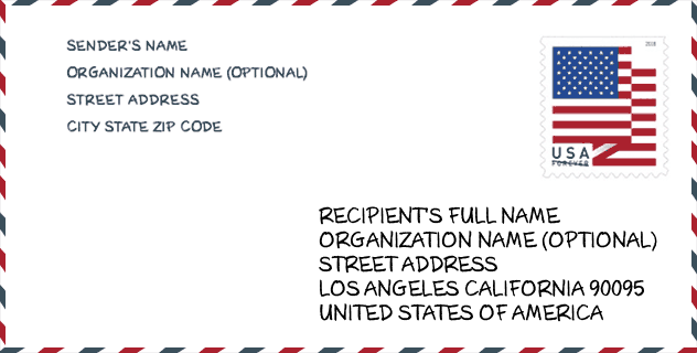
Envelope Example

This is an example of a US zip envelope. You can use a 5-digit zipcode or a detailed 9-digit zipcode to copy the mail in the following address format.
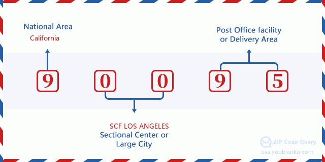
90095 Basic Meaning
What does each digit of ZIP Code 90095 stands for? The first digit designates a national area, which ranges from zero for the Northeast to nine for the far West. The 2-3 digits are the code of a sectional center facility in that region. The last two digits designate small post offices or postal zones.
Online Map

This is online map of the address Uc Los Angeles, California, United States. You may use button to move and zoom in / out. The map information is for reference only.
Hospital

This is the ZIP Code 90095 - Hospital page list. Its detail Hospital Name, Street, City, State, ZIP Code, Phone is as below.
| Name | Address | City | State | ZIP Code | Phone |
|---|---|---|---|---|---|
| RESNICK NEUROPSYCHIATRIC HOSPITAL AT UCLA | 150 MEDICAL PLAZA-RM-4230C | LOS ANGELES | CA | 90095 | (310) 825-6962 |
| RONALD REAGAN UCLA MEDICAL CENTER | 757 WESTWOOD PLAZA | LOS ANGELES | CA | 90095 | (310) 825-6301 |
Museum

This is the ZIP Code 90095 - Museum page list. Its detail Museum Name, Street, City, State, ZIP Code, Phone is as below.
| Name | Street | City | State | ZIP Code | Phone |
| UCLA COLLECTION OF METEORITES | 595 CHARLES E YOUNG DR | LOS ANGELES | CA | 90095 | |
| UCLA PLANETARIUM | 405 HIL GARD AVENUE ROOM NO 8224 | LOS ANGELES | CA | 90095 | (310) 825-4434 |
| MILDRED E. MATHIAS BOTANICAL GARDEN | 777 TIVERTON DRIVE | LOS ANGELES | CA | 90095 | (310) 825-1260 |
| WIGHT ART GALLERY | 240 CHARLES E YOUNG DRIVE NORTH | LOS ANGELES | CA | 90095 | (310) 825-0557 |
Gender

In all the statistical population, the male population is 2, the female population is 1.
- Male Population: 2
- Female Population: 1
Race

In all the statistical population, the male population is 2, the female population is 1.
- White Population: 1
- Black Population: 0
- Hispanic Population: 0
- Asian Population: 2
- Hawaiian Population: 0
- Indian Population: 0
- Other Population: 0
Age

In all the statistical population, the White population is 1, the Black population is 0, the Hispanic population is 0, the Asian population is 2, the Hawaiian population is 0, the Indian Ppopulation is 0 and Other population is 0.
- Age's Median: 52.5
- Median of male age: 38.5
- Median of female age: 52.5
Households for ZIP Code 90095
ZIP code 90095 has 2 households, with an average number of 1.50 persons per household. The average income per household in Zip code 90095 is 0 USD, and the average house value is 0 USD.
- Households Per Zipcode: 2
- Persons Per Household: 1.50
- Average House Value: 0
- Income Per Household: 0
Geographic

The latitude of the Zip code 90095 is 34.071042, the longitude is -118.443236, and the elevation is 420. It has land area of 0.397 square miles, and water area of 0 square miles. The time zone for ZIP code 90095 is Pacific (GMT -08:00). Daylight saving time should be observed in the area where the zip code is located.
- Latitude: 34.071042
- Longitude: -118.443236
- Elevation: 420
- Land Area: 0.397
- Water Area: 0
- Time Zone: Pacific (GMT -08:00)
- Region: West
- Division: Pacific
- Day Light Saving: Y
Congressional District

The Congressional District for ZIP code 90095 is California's 33th congressional district, the Congressional Land Area is 288.58 square mile.
- Congressional District: 33th
- Congressional Land Area: 288.58
Delivery

In the ZIP code 90095, there are 0 residential delivery mailboxes and centralized units, and 1 commercial delivery mailbox and centralized units, 0 single family deliveries and 0 multifamily deliveries, and the box count is 2,430. The main post office does not have city delivery carrier routes for the ZIP code 90095.
- Delivery Residential: 0
- Delivery Business: 1
- Delivery Total: 2,430
- Single Family Delivery Units: 0
- Multi Family Delivery Units: 0
- City Delivery Indicator: N
Business

In ZIP code 90095, the number of business is 34, the number of employee is 428, the business first quarter payroll is 6,238,000 USD, the business annual payroll is 28,259,000 USD.
- Number Of Businesses: 34
- Number Of Employees: 428
- Business First Quarter Payroll: 6,238,000
- Business Annual Payroll: 28,259,000


Add new comment