United States ZIP Code: 90639
This is the California ZIP Code 90639 page list. Its detail State, County, City/Agency, Longitude, Latitude, Envelope Example, Population is as below.

ZIP Code 90639 Information

-
-
Country:
U.S. - United States
State:
State FIPS:
06
Area Code:
ZIP Code:
90639
ZIP Type:
U (Unique)
❓What does U (Unique) mean? Companies, organizations, and institutions that receive large quantities of mail are given a "unique" ZIP Code type.
-


-
Iconic US Landmark Legacy Designs
Get PNG, SVG, EPS, AI, PDF Versions at Just $0.1
 Download Now
-


ZipCodeCraft
ZIP Code 90639 - City/Agency

This is the city information corresponding to 90639:
| State | County | City/Agency | City Type ?In many cases, a ZIP Code can have multiple "names", meaning cities, towns, or subdivisions, in its boundaries. However, it will ALWAYS have exactly 1 "default" name. D - Default - This is the "preferred" name - by the USPS - for a city. Each ZIP Code has one - and only one - "default" name. In most cases, this is what people who live in that area call the city as well. A - Acceptable - This name can be used for mailing purposes. Often times alternative names are large neighborhoods or sections of the city/town. In some cases a ZIP Code may have several "acceptable" names which is used to group towns under one ZIP Code. N - Not Acceptable - A "not acceptable" name is, in many cases, a nickname that residents give that location. According to the USPS, you should NOT send mail to that ZIP Code using the "not acceptable" name when mailing. | ZIP Code |
|---|---|---|---|---|
| CA | Los Angeles | Biola University | N (Not Acceptable) | 90639 |
| CA | Los Angeles | La Mirada | D (Default) | 90639 |
❓What does D (Default) mean? This is the "preferred" name - by the USPS - for a city. Each ZIP Code has one - and only one - "default" name. In most cases, this is what people who live in that area call the city as well.
❓What does N (Not Acceptable) mean? A "not acceptable" name is, in many cases, a nickname that residents give that location. According to the USPS, you should NOT send mail to that ZIP Code using the "not acceptable" name when mailing.
ZIP Code 90639 Plus 4
ZIP Code 5 plus 4 is the extension of 5-digit zip code, It can be used to locate a more detailed location. The last four digits designate segment or one side of a street or an apartment. You can find the ZIP+4 code and corresponding address of the zip code 90639 below.
| ZIP Code 5 Plus 4 | Address |
|---|---|
| 90639-0001 | 13800 BIOLA AVE, LA MIRADA, CA |
| 90639-0002 | 13800 BIOLA AVE, LA MIRADA, CA |
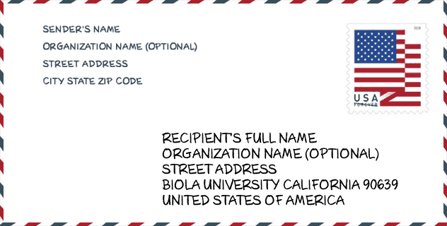
Envelope Example

This is an example of a US zip envelope. You can use a 5-digit zipcode or a detailed 9-digit zipcode to copy the mail in the following address format.
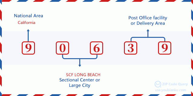
90639 Basic Meaning
What does each digit of ZIP Code 90639 stands for? The first digit designates a national area, which ranges from zero for the Northeast to nine for the far West. The 2-3 digits are the code of a sectional center facility in that region. The last two digits designate small post offices or postal zones.
Online Map

This is online map of the address La Mirada, California, United States. You may use button to move and zoom in / out. The map information is for reference only.
Museum

This is the ZIP Code 90639 - Museum page list. Its detail Museum Name, Street, City, State, ZIP Code, Phone is as below.
- Name: ART GALLERY
- Street: 13800 BIOLA AVE
- City: LA MIRADA
- State: CA
- ZIP Code: 90639
- Phone: (562) 903-6000
Geographic

The latitude of the Zip code 90639 is 33.906793, the longitude is -118.015356, and the elevation is 145. It has land area of 0 square miles, and water area of 0 square miles. The time zone for ZIP code 90639 is Pacific (GMT -08:00). Daylight saving time should be observed in the area where the zip code is located.
- Latitude: 33.906793
- Longitude: -118.015356
- Elevation: 145
- Land Area: 0
- Water Area: 0
- Time Zone: Pacific (GMT -08:00)
- Region: West
- Division: Pacific
- Day Light Saving: Y
Congressional District

The Congressional District for ZIP code 90639 is California's 38th congressional district, the Congressional Land Area is 101.46 square mile.
- Congressional District: 38th
- Congressional Land Area: 101.46
Delivery

In the ZIP code 90639, there are 0 residential delivery mailboxes and centralized units, and 0 commercial delivery mailbox and centralized units, 0 single family deliveries and 0 multifamily deliveries, and the box count is 480. The main post office does not have city delivery carrier routes for the ZIP code 90639.
- Delivery Residential: 0
- Delivery Business: 0
- Delivery Total: 480
- Single Family Delivery Units: 0
- Multi Family Delivery Units: 0
- City Delivery Indicator: N
Business

In ZIP code 90639, the number of business is 9, the number of employee is 3,082, the business first quarter payroll is 21,102,000 USD, the business annual payroll is 86,305,000 USD.
- Number Of Businesses: 9
- Number Of Employees: 3,082
- Business First Quarter Payroll: 21,102,000
- Business Annual Payroll: 86,305,000


Add new comment