ZIP Code: 96701, Aiea, HI
ZIP Code 96701 is located in Aiea, Hawaii. Its detail State, County, City, Longitude, Latitude, Envelope Example, Population is as below.

ZIP Code 96701 Information

-
-
Country:
U.S. - United States
State:
County FIPS:
15003
County:
City:
Area Code:
City Type ?In many cases, a ZIP Code can have multiple "names", meaning cities, towns, or subdivisions, in its boundaries. However, it will ALWAYS have exactly 1 "default" name. D - Default - This is the "preferred" name - by the USPS - for a city. Each ZIP Code has one - and only one - "default" name. In most cases, this is what people who live in that area call the city as well. A - Acceptable - This name can be used for mailing purposes. Often times alternative names are large neighborhoods or sections of the city/town. In some cases a ZIP Code may have several "acceptable" names which is used to group towns under one ZIP Code. N - Not Acceptable - A "not acceptable" name is, in many cases, a nickname that residents give that location. According to the USPS, you should NOT send mail to that ZIP Code using the "not acceptable" name when mailing.:
D (Default)
ZIP Code:
96701
❓What does D (Default) mean? This is the "preferred" name - by the USPS - for a city. Each ZIP Code has one - and only one - "default" name. In most cases, this is what people who live in that area call the city as well.
-


-
Iconic US Landmark Legacy Designs
Get PNG, SVG, EPS, AI, PDF Versions at Just $0.1
 Download Now
-


ZipCodeCraft
ZIP Code 96701 Plus 4
ZIP Code 5 plus 4 is the extension of 5-digit zip code, It can be used to locate a more detailed location. The last four digits designate segment or one side of a street or an apartment. You can find the ZIP+4 code and corresponding address of the zip code 96701 below.
| ZIP Code 5 Plus 4 | Address |
|---|---|
| 96701-0001 | PO BOX 1, AIEA, HI |
| 96701-0028 | PO BOX 28, AIEA, HI |
| 96701-0031 | PO BOX 31, AIEA, HI |
| 96701-0121 | PO BOX 121, AIEA, HI |
| 96701-0241 | PO BOX 241, AIEA, HI |
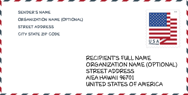
Envelope Example

This is an example of a US zip envelope. You can use a 5-digit zipcode or a detailed 9-digit zipcode to copy the mail in the following address format.
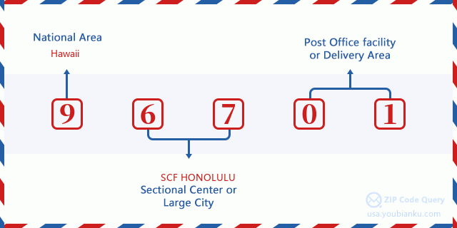
96701 Basic Meaning
What does each digit of ZIP Code 96701 stands for? The first digit designates a national area, which ranges from zero for the Northeast to nine for the far West. The 2-3 digits are the code of a sectional center facility in that region. The last two digits designate small post offices or postal zones.
Online Map

This is online map of the address Aiea, Hawaii, United States. You may use button to move and zoom in / out. The map information is for reference only.
Hospital

This is the ZIP Code 96701 - Hospital page list. Its detail Hospital Name, Street, City, State, ZIP Code, Phone is as below.
- Name: PALI MOMI MEDICAL CENTER
- Address: AIEA
- City: 98-1079 MOANALUA ROAD
- State: HI
- ZIP Code: 96701
- Phone: (808) 486-6000
Museum

This is the ZIP Code 96701 - Museum page list. Its detail Museum Name, Street, City, State, ZIP Code, Phone is as below.
- Name: HAWAII SWIMMING LEGACY PROJECT
- Street: 99-1782 AIEA HEIGHTS DRIVE
- City: AIEA
- State: HI
- ZIP Code: 96701
- Phone:
Library

This is the ZIP Code 96701 - Library page list. Its detail Library Name, Address, City, State, ZIP Code, Phone is as below.
- Name: AIEA PUBLIC LIBRARY
- Address: 99-374 POHAI PLACE
- City: AIEA
- State: HI - Hawaii
- ZIP Code: 96701
- Phone: (808) 483-7333
School

This is the ZIP Code 96701 - School page list. Its detail School Name, Address, City, State, ZIP Code is as below.
| School Name | Address | City | State | Grades | ZIP Code |
|---|---|---|---|---|---|
| Gustav H Webling Elementary School | 99-370 Paihi St | Aiea | HI | UG | 96701 |
| Waimalu Elementary School | 98-825 Moanalua Rd | Aiea | HI | UG | 96701 |
| Alvah A Scott Elementary School | 98-1230 Moanalua Rd | Aiea | HI | UG | 96701 |
| Pearl Ridge Elementary School | 98-940 Moanalua Rd | Aiea | HI | UG | 96701 |
| Aiea Intermediate School | 99-600 Kulawea St | Aiea | HI | UG | 96701 |
| Aiea High School | 98-1276 Ulune St | Aiea | HI | UG | 96701 |
| Aiea Elementary School | 99-370 Moanalua Rd | Aiea | HI | UG | 96701 |
Population for ZIP Code 96701

What is the total population in ZIP Code 96701? Below is detail information.
- Population for ZIP Code 96701: 39,173
- 2010 Population: 40,281
The 2020 demographic statistics are in progress. The current population in ZIP code 96701 is 39,173, and the population in 2010 is 40,281.
Gender

In all the statistical population, the male population is 20,577, the female population is 19,704.
- Male Population: 20,577
- Female Population: 19,704
Race

In all the statistical population, the male population is 20,577, the female population is 19,704.
- White Population: 11,450
- Black Population: 1,116
- Hispanic Population: 2,859
- Asian Population: 29,016
- Hawaiian Population: 8,837
- Indian Population: 617
- Other Population: 675
Age

In all the statistical population, the White population is 11,450, the Black population is 1,116, the Hispanic population is 2,859, the Asian population is 29,016, the Hawaiian population is 8,837, the Indian Ppopulation is 617 and Other population is 675.
- Age's Median: 42.2
- Median of male age: 40.3
- Median of female age: 44.6
Households for ZIP Code 96701
ZIP code 96701 has 13,527 households, with an average number of 2.89 persons per household. The average income per household in Zip code 96701 is 95,223 USD, and the average house value is 655,300 USD.
- Households Per Zipcode: 13,527
- Persons Per Household: 2.89
- Average House Value: 655,300
- Income Per Household: 95,223
Geographic

The latitude of the Zip code 96701 is 21.396288, the longitude is -157.896389, and the elevation is 971. It has land area of 18.907 square miles, and water area of 0.777 square miles. The time zone for ZIP code 96701 is Hawaii-Aleutian Islands (GMT -10:00). Daylight saving time should be observed in the area where the zip code is located.
- Latitude: 21.396288
- Longitude: -157.896389
- Elevation: 971
- Land Area: 18.907
- Water Area: 0.777
- Time Zone: Hawaii-Aleutian Islands (GMT -10:00)
- Region: West
- Division: Pacific
- Day Light Saving: N
Congressional District

The Congressional District for ZIP code 96701 is Hawaii's 1st congressional district, the Congressional Land Area is 209.22 square mile.
- Congressional District: 1st
- Congressional Land Area: 209.22
Delivery

In the ZIP code 96701, there are 13,555 residential delivery mailboxes and centralized units, and 1,150 commercial delivery mailbox and centralized units, 7,362 single family deliveries and 4,067 multifamily deliveries, and the box count is 15,674. The main post office has city delivery carrier routes for the ZIP code 96701.
- Delivery Residential: 13,555
- Delivery Business: 1,150
- Delivery Total: 15,674
- Single Family Delivery Units: 7,362
- Multi Family Delivery Units: 4,067
- City Delivery Indicator: Y
Business

In ZIP code 96701, the number of business is 1,050, the number of employee is 14,883, the business first quarter payroll is 166,887,000 USD, the business annual payroll is 671,728,000 USD.
- Number Of Businesses: 1,050
- Number Of Employees: 14,883
- Business First Quarter Payroll: 166,887,000
- Business Annual Payroll: 671,728,000
Social Security Benefits

There are 9,065 beneficiaries with benefits in current-payment status for ZIP code 96701, of which 7,620 are retired workers, 440 are disabled workers, 415 are widow(er)s and parents, 310 are spouses and 280 are children. The number of beneficiaries aged 65 or older is 8,045. The total monthly benefits are 13,743,000 USD, of which 12,092,000 USD for retired workers, 571,000 USD for widow(er)s and parents.
- Total Number: 9,065
- Retired workers Number: 7,620
- Disabled workers Number: 440
- Widow(er)s and parents Number: 415
- Spouses Number: 310
- Children Number: 280
- All beneficiaries per month: 13,743,000
- Retired workers per month: 12,092,000
- Widow(er)s and parents per month: 571,000
- Number of beneficiaries aged 65 or older: 8,045


Add new comment