United States ZIP Code: 41701
This is the Kentucky ZIP Code 41701 page list. Its detail State, County, City, Longitude, Latitude, Envelope Example, Population is as below.

ZIP Code 41701 Information

-
-
Country:
U.S. - United States
State:
State FIPS:
21
Area Code:
ZIP Code:
41701
ZIP Type:
S (Standard)
❓What does S (Standard) mean? A "standard" ZIP Code is what most people think of when they talk about ZIP Codes - essentially a town, city, or a division of a city that has mail service.
-


-
Iconic US Landmark Legacy Designs
Get PNG, SVG, EPS, AI, PDF Versions at Just $0.1
 Download Now
-


ZipCodeCraft
ZIP Code 41701 - City

This is the city information corresponding to 41701:
| State | County | City | City Type ?In many cases, a ZIP Code can have multiple "names", meaning cities, towns, or subdivisions, in its boundaries. However, it will ALWAYS have exactly 1 "default" name. D - Default - This is the "preferred" name - by the USPS - for a city. Each ZIP Code has one - and only one - "default" name. In most cases, this is what people who live in that area call the city as well. A - Acceptable - This name can be used for mailing purposes. Often times alternative names are large neighborhoods or sections of the city/town. In some cases a ZIP Code may have several "acceptable" names which is used to group towns under one ZIP Code. N - Not Acceptable - A "not acceptable" name is, in many cases, a nickname that residents give that location. According to the USPS, you should NOT send mail to that ZIP Code using the "not acceptable" name when mailing. | ZIP Code |
|---|---|---|---|---|
| KY | Perry | Browns Fork | A (Acceptable) | 41701 |
| KY | Perry | Darfork | N (Not Acceptable) | 41701 |
| KY | Perry | Hazard | D (Default) | 41701 |
| KY | Perry | Typo | A (Acceptable) | 41701 |
| KY | Perry | Walkertown | A (Acceptable) | 41701 |
❓What does D (Default) mean? This is the "preferred" name - by the USPS - for a city. Each ZIP Code has one - and only one - "default" name. In most cases, this is what people who live in that area call the city as well.
❓What does A (Acceptable) mean? This name can be used for mailing purposes. Often times alternative names are large neighborhoods or sections of the city/town. In some cases a ZIP Code may have several "acceptable" names which is used to group towns under one ZIP Code.
❓What does N (Not Acceptable) mean? A "not acceptable" name is, in many cases, a nickname that residents give that location. According to the USPS, you should NOT send mail to that ZIP Code using the "not acceptable" name when mailing.
ZIP Code 41701 Plus 4
ZIP Code 5 plus 4 is the extension of 5-digit zip code, It can be used to locate a more detailed location. The last four digits designate segment or one side of a street or an apartment. You can find the ZIP+4 code and corresponding address of the zip code 41701 below.
| ZIP Code 5 Plus 4 | Address |
|---|---|
| 41701-1000 | 300 ORCHARD ST, HAZARD, KY |
| 41701-1001 | 101 BARTLETT ST, HAZARD, KY |
| 41701-1002 | 100 BARTLETT ST, HAZARD, KY |
| 41701-1003 | 100 BRASHEAR DR, HAZARD, KY |
| 41701-1004 | 101 BRASHEAR DR, HAZARD, KY |
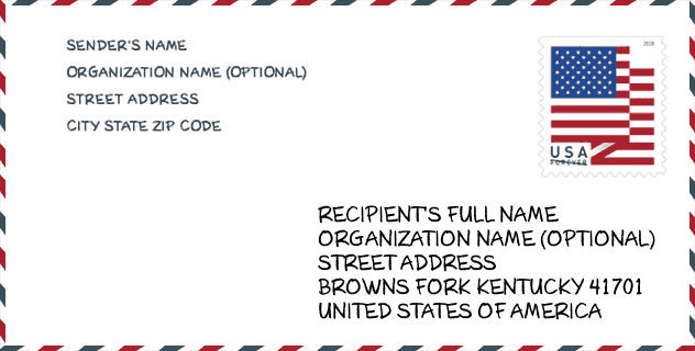
Envelope Example

This is an example of a US zip envelope. You can use a 5-digit zipcode or a detailed 9-digit zipcode to copy the mail in the following address format.
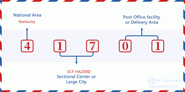
41701 Basic Meaning
What does each digit of ZIP Code 41701 stands for? The first digit designates a national area, which ranges from zero for the Northeast to nine for the far West. The 2-3 digits are the code of a sectional center facility in that region. The last two digits designate small post offices or postal zones.
Online Map

This is online map of the address Walkertown, Kentucky, United States. You may use button to move and zoom in / out. The map information is for reference only.
Hospital

This is the ZIP Code 41701 - Hospital page list. Its detail Hospital Name, Street, City, State, ZIP Code, Phone is as below.
- Name: HAZARD ARH REGIONAL MEDICAL CENTER
- Address: HAZARD
- City: 100 MEDICAL CENTER DRIVE
- State: KY
- ZIP Code: 41701
- Phone: (606) 439-6600
Museum

This is the ZIP Code 41701 - Museum page list. Its detail Museum Name, Street, City, State, ZIP Code, Phone is as below.
- Name: BOBBY DAVIS MUSEUM
- Street: 234 WALNUT STREET
- City: HAZARD
- State: KY
- ZIP Code: 41701
- Phone: (606) 439-4325
School

This is the ZIP Code 41701 - School page list. Its detail School Name, Address, City, State, ZIP Code is as below.
| School Name | Address | City | State | Grades | ZIP Code |
|---|---|---|---|---|---|
| Hazard High School | 157 Bulldog Ln | Hazard | KY | UG | 41701 |
| Hazard Middle School | 325 School Street | Hazard | KY | UG | 41701 |
| Roy G. Eversole Elementary School | 601 Broadway | Hazard | KY | UG | 41701 |
| Kentucky TECH - Hazard Regional Tech Ctr | 101 Vo-Tech Drive | Hazard | KY | UG | 41701 |
| Hazard Community College Tech Campus | 101 Vo-Tech Drive | Hazard | KY | UG | 41701 |
| Cordia School | 6050 Lotts Creek Road | Hazard | KY | UG | 41701 |
| Perry County Central High School | 305 Park Ave | Hazard | KY | UG | 41701 |
| East Perry County Elementary School | 301 Perry Circle Rd | Hazard | KY | UG | 41701 |
| Perry County Alternative School | 72 Edna Lane | Hazard | KY | UG | 41701 |
| Learning Academy | 305 Park Avenue | Hazard | KY | UG | 41701 |
| West Perry Elementary School | 72 Miss Edna Lane | Hazard | KY | UG | 41701 |
Population for ZIP Code 41701

What is the total population in ZIP Code 41701? Below is detail information.
- Population for ZIP Code 41701: 14,663
- 2010 Population: 17,252
The 2020 demographic statistics are in progress. The current population in ZIP code 41701 is 14,663, and the population in 2010 is 17,252.
Gender

In all the statistical population, the male population is 8,458, the female population is 8,794.
- Male Population: 8,458
- Female Population: 8,794
Race

In all the statistical population, the male population is 8,458, the female population is 8,794.
- White Population: 16,636
- Black Population: 515
- Hispanic Population: 113
- Asian Population: 151
- Hawaiian Population: 5
- Indian Population: 94
- Other Population: 66
Age

In all the statistical population, the White population is 16,636, the Black population is 515, the Hispanic population is 113, the Asian population is 151, the Hawaiian population is 5, the Indian Ppopulation is 94 and Other population is 66.
- Age's Median: 40.2
- Median of male age: 39.1
- Median of female age: 41.5
Households for ZIP Code 41701
ZIP code 41701 has 6,810 households, with an average number of 2.45 persons per household. The average income per household in Zip code 41701 is 38,000 USD, and the average house value is 79,400 USD.
- Households Per Zipcode: 6,810
- Persons Per Household: 2.45
- Average House Value: 79,400
- Income Per Household: 38,000
Geographic

The latitude of the Zip code 41701 is 37.286851, the longitude is -83.183610, and the elevation is 1130. It has land area of 147.888 square miles, and water area of 0.848 square miles. The time zone for ZIP code 41701 is Eastern (GMT -05:00). Daylight saving time should be observed in the area where the zip code is located.
- Latitude: 37.286851
- Longitude: -83.183610
- Elevation: 1130
- Land Area: 147.888
- Water Area: 0.848
- Time Zone: Eastern (GMT -05:00)
- Region: South
- Division: East South Central
- Day Light Saving: Y
Congressional District

The Congressional District for ZIP code 41701 is Kentucky's 05th congressional district, the Congressional Land Area is 11235.15 square mile.
- Congressional District: 05th
- Congressional Land Area: 11235.15
Delivery

In the ZIP code 41701, there are 5,985 residential delivery mailboxes and centralized units, and 641 commercial delivery mailbox and centralized units, 4,990 single family deliveries and 159 multifamily deliveries, and the box count is 6,508. The main post office has city delivery carrier routes for the ZIP code 41701.
- Delivery Residential: 5,985
- Delivery Business: 641
- Delivery Total: 6,508
- Single Family Delivery Units: 4,990
- Multi Family Delivery Units: 159
- City Delivery Indicator: Y
Business

In ZIP code 41701, the number of business is 448, the number of employee is 7,922, the business first quarter payroll is 75,899,000 USD, the business annual payroll is 308,826,000 USD.
- Number Of Businesses: 448
- Number Of Employees: 7,922
- Business First Quarter Payroll: 75,899,000
- Business Annual Payroll: 308,826,000
Social Security Benefits

There are 2,855 beneficiaries with benefits in current-payment status for ZIP code 41701, of which 1,345 are retired workers, 755 are disabled workers, 275 are widow(er)s and parents, 155 are spouses and 325 are children. The number of beneficiaries aged 65 or older is 1,670. The total monthly benefits are 3,575,000 USD, of which 1,936,000 USD for retired workers, 342,000 USD for widow(er)s and parents.
- Total Number: 2,855
- Retired workers Number: 1,345
- Disabled workers Number: 755
- Widow(er)s and parents Number: 275
- Spouses Number: 155
- Children Number: 325
- All beneficiaries per month: 3,575,000
- Retired workers per month: 1,936,000
- Widow(er)s and parents per month: 342,000
- Number of beneficiaries aged 65 or older: 1,670


Add new comment