ZIP Code: 46544, Mishawaka, IN
ZIP Code 46544 is located in Mishawaka, Indiana. Its detail State, County, City, Longitude, Latitude, Envelope Example, Population is as below.
ZIP Code 46544 Information

-
-
Country:
U.S. - United States
State:
County FIPS:
18141
City:
Area Code:
City Type ?In many cases, a ZIP Code can have multiple "names", meaning cities, towns, or subdivisions, in its boundaries. However, it will ALWAYS have exactly 1 "default" name. D - Default - This is the "preferred" name - by the USPS - for a city. Each ZIP Code has one - and only one - "default" name. In most cases, this is what people who live in that area call the city as well. A - Acceptable - This name can be used for mailing purposes. Often times alternative names are large neighborhoods or sections of the city/town. In some cases a ZIP Code may have several "acceptable" names which is used to group towns under one ZIP Code. N - Not Acceptable - A "not acceptable" name is, in many cases, a nickname that residents give that location. According to the USPS, you should NOT send mail to that ZIP Code using the "not acceptable" name when mailing.:
D (Default)
ZIP Code:
46544
❓What does D (Default) mean? This is the "preferred" name - by the USPS - for a city. Each ZIP Code has one - and only one - "default" name. In most cases, this is what people who live in that area call the city as well.
-


-
Iconic US Landmark Legacy Designs
Get PNG, SVG, EPS, AI, PDF Versions at Just $0.1
 Download Now
-


ZipCodeCraft
ZIP Code 46544 Plus 4
ZIP Code 5 plus 4 is the extension of 5-digit zip code, It can be used to locate a more detailed location. The last four digits designate segment or one side of a street or an apartment. You can find the ZIP+4 code and corresponding address of the zip code 46544 below.
| ZIP Code 5 Plus 4 | Address |
|---|---|
| 46544-1200 | 100 N CENTER ST, MISHAWAKA, IN |
| 46544-1201 | 100 N CENTER ST #00000125 , MISHAWAKA, IN |
| 46544-1202 | 101 OLD STABLE LN, MISHAWAKA, IN |
| 46544-1203 | 130 TOWLE AVE, MISHAWAKA, IN |
| 46544-1204 | 501 VERGAUWEN CT, MISHAWAKA, IN |
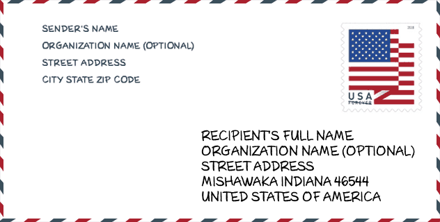
Envelope Example

This is an example of a US zip envelope. You can use a 5-digit zipcode or a detailed 9-digit zipcode to copy the mail in the following address format.
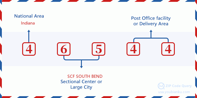
46544 Basic Meaning
What does each digit of ZIP Code 46544 stands for? The first digit designates a national area, which ranges from zero for the Northeast to nine for the far West. The 2-3 digits are the code of a sectional center facility in that region. The last two digits designate small post offices or postal zones.
Online Map

This is online map of the address Mishawaka, Indiana, United States. You may use button to move and zoom in / out. The map information is for reference only.
Library

This is the ZIP Code 46544 - Library page list. Its detail Library Name, Address, City, State, ZIP Code, Phone is as below.
| Name | Address | City | State | ZIP Code | Phone |
|---|---|---|---|---|---|
| BITTERSWEET BRANCH LIBRARY | 602 BITTERSWEET ROAD | MISHAWAKA | IN | 46544 | (574) 259-5277 |
| MISHAWAKA-PENN-HARRIS PUBLIC LIBRARY | 209 LINCOLN WAY EAST | MISHAWAKA | IN | 46544 | (574) 259-5277 |
School

This is the ZIP Code 46544 - School page list. Its detail School Name, Address, City, State, ZIP Code is as below.
| School Name | Address | City | State | Grades | ZIP Code |
|---|---|---|---|---|---|
| Oaklawn Campus Program | 1411 Lincolnway West | Mishawaka | IN | UG | 46544 |
| Beiger Elementary School | 1600 E Third St | Mishawaka | IN | UG | 46544 |
| Emmons Elementary School | 1306 S Main St | Mishawaka | IN | UG | 46544 |
| Fred J Hums Elementary School | 3208 Harrison Rd | Mishawaka | IN | UG | 46544 |
| Lasalle Elementary School | 1511 Milburn Blvd | Mishawaka | IN | UG | 46544 |
| Mishawaka High School | 1202 Lincolnway E | Mishawaka | IN | UG | 46544 |
| Twin Branch Elementary School | 3810 Lincoln Way E | Mishawaka | IN | UG | 46544 |
| Meadow's Edge Elementary School | 16333 Kern Rd | Mishawaka | IN | UG | 46544 |
| Elm Road Elementary School | 59400 Elm Rd | Mishawaka | IN | UG | 46544 |
| Virgil I Grissom Middle School | 13881 Kern Rd | Mishawaka | IN | UG | 46544 |
Population for ZIP Code 46544

What is the total population in ZIP Code 46544? Below is detail information.
- Population for ZIP Code 46544: 33,653
- 2010 Population: 30,759
The 2020 demographic statistics are in progress. The current population in ZIP code 46544 is 33,653, and the population in 2010 is 30,759.
Gender

In all the statistical population, the male population is 14,860, the female population is 15,899.
- Male Population: 14,860
- Female Population: 15,899
Race

In all the statistical population, the male population is 14,860, the female population is 15,899.
- White Population: 28,761
- Black Population: 1,670
- Hispanic Population: 969
- Asian Population: 347
- Hawaiian Population: 34
- Indian Population: 352
- Other Population: 464
Age

In all the statistical population, the White population is 28,761, the Black population is 1,670, the Hispanic population is 969, the Asian population is 347, the Hawaiian population is 34, the Indian Ppopulation is 352 and Other population is 464.
- Age's Median: 37.2
- Median of male age: 35.8
- Median of female age: 38.5
Households for ZIP Code 46544
ZIP code 46544 has 12,664 households, with an average number of 2.41 persons per household. The average income per household in Zip code 46544 is 47,778 USD, and the average house value is 106,100 USD.
- Households Per Zipcode: 12,664
- Persons Per Household: 2.41
- Average House Value: 106,100
- Income Per Household: 47,778
Geographic

The latitude of the Zip code 46544 is 41.619622, the longitude is -86.138166, and the elevation is 855. It has land area of 40.105 square miles, and water area of 0.298 square miles. The time zone for ZIP code 46544 is Eastern (GMT -05:00). Daylight saving time should be observed in the area where the zip code is located.
- Latitude: 41.619622
- Longitude: -86.138166
- Elevation: 855
- Land Area: 40.105
- Water Area: 0.298
- Time Zone: Eastern (GMT -05:00)
- Region: Midwest
- Division: East North Central
- Day Light Saving: Y
Congressional District

The Congressional District for ZIP code 46544 is Indiana's 2nd congressional district, the Congressional Land Area is 3958.58 square mile.
- Congressional District: 2nd
- Congressional Land Area: 3958.58
Delivery

In the ZIP code 46544, there are 13,964 residential delivery mailboxes and centralized units, and 651 commercial delivery mailbox and centralized units, 10,591 single family deliveries and 2,305 multifamily deliveries, and the box count is 14,599. The main post office has city delivery carrier routes for the ZIP code 46544.
- Delivery Residential: 13,964
- Delivery Business: 651
- Delivery Total: 14,599
- Single Family Delivery Units: 10,591
- Multi Family Delivery Units: 2,305
- City Delivery Indicator: Y
Business

In ZIP code 46544, the number of business is 545, the number of employee is 11,216, the business first quarter payroll is 134,248,000 USD, the business annual payroll is 523,476,000 USD.
- Number Of Businesses: 545
- Number Of Employees: 11,216
- Business First Quarter Payroll: 134,248,000
- Business Annual Payroll: 523,476,000
Social Security Benefits

There are 6,290 beneficiaries with benefits in current-payment status for ZIP code 46544, of which 4,380 are retired workers, 890 are disabled workers, 420 are widow(er)s and parents, 175 are spouses and 425 are children. The number of beneficiaries aged 65 or older is 4,655. The total monthly benefits are 8,846,000 USD, of which 6,673,000 USD for retired workers, 624,000 USD for widow(er)s and parents.
- Total Number: 6,290
- Retired workers Number: 4,380
- Disabled workers Number: 890
- Widow(er)s and parents Number: 420
- Spouses Number: 175
- Children Number: 425
- All beneficiaries per month: 8,846,000
- Retired workers per month: 6,673,000
- Widow(er)s and parents per month: 624,000
- Number of beneficiaries aged 65 or older: 4,655


Add new comment