ZIP Code: 46933, Gas City, IN
ZIP Code 46933 is located in Gas City, Indiana. Its detail State, County, City, Longitude, Latitude, Envelope Example, Population is as below.

ZIP Code 46933 Information

-
-
Country:
U.S. - United States
State:
County FIPS:
18053
County:
City:
Area Code:
City Type ?In many cases, a ZIP Code can have multiple "names", meaning cities, towns, or subdivisions, in its boundaries. However, it will ALWAYS have exactly 1 "default" name. D - Default - This is the "preferred" name - by the USPS - for a city. Each ZIP Code has one - and only one - "default" name. In most cases, this is what people who live in that area call the city as well. A - Acceptable - This name can be used for mailing purposes. Often times alternative names are large neighborhoods or sections of the city/town. In some cases a ZIP Code may have several "acceptable" names which is used to group towns under one ZIP Code. N - Not Acceptable - A "not acceptable" name is, in many cases, a nickname that residents give that location. According to the USPS, you should NOT send mail to that ZIP Code using the "not acceptable" name when mailing.:
D (Default)
ZIP Code:
46933
❓What does D (Default) mean? This is the "preferred" name - by the USPS - for a city. Each ZIP Code has one - and only one - "default" name. In most cases, this is what people who live in that area call the city as well.
-


-
Iconic US Landmark Legacy Designs
Get PNG, SVG, EPS, AI, PDF Versions at Just $0.1
 Download Now
-


ZipCodeCraft
ZIP Code 46933 Plus 4
ZIP Code 5 plus 4 is the extension of 5-digit zip code, It can be used to locate a more detailed location. The last four digits designate segment or one side of a street or an apartment. You can find the ZIP+4 code and corresponding address of the zip code 46933 below.
| ZIP Code 5 Plus 4 | Address |
|---|---|
| 46933-0001 | PO BOX 1, GAS CITY, IN |
| 46933-0121 | PO BOX 121, GAS CITY, IN |
| 46933-0241 | PO BOX 241, GAS CITY, IN |
| 46933-0361 | PO BOX 361, GAS CITY, IN |
| 46933-0481 | PO BOX 481, GAS CITY, IN |
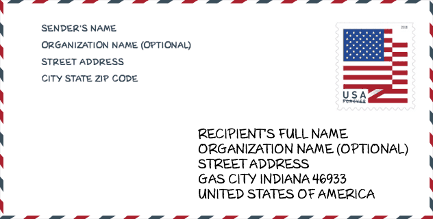
Envelope Example

This is an example of a US zip envelope. You can use a 5-digit zipcode or a detailed 9-digit zipcode to copy the mail in the following address format.
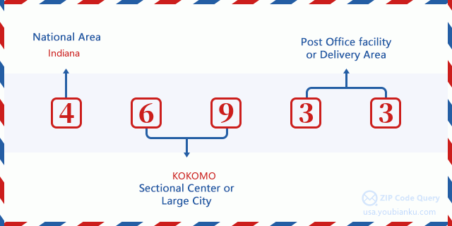
46933 Basic Meaning
What does each digit of ZIP Code 46933 stands for? The first digit designates a national area, which ranges from zero for the Northeast to nine for the far West. The 2-3 digits are the code of a sectional center facility in that region. The last two digits designate small post offices or postal zones.
Online Map

This is online map of the address Gas City, Indiana, United States. You may use button to move and zoom in / out. The map information is for reference only.
Library

This is the ZIP Code 46933 - Library page list. Its detail Library Name, Address, City, State, ZIP Code, Phone is as below.
- Name: GAS CITY-MILL TOWNSHIP PUBLIC LIBRARY
- Address: 135 EAST MAIN STREET
- City: GAS CITY
- State: IN - Indiana
- ZIP Code: 46933
- Phone: (765) 674-4718
School

This is the ZIP Code 46933 - School page list. Its detail School Name, Address, City, State, ZIP Code is as below.
| School Name | Address | City | State | Grades | ZIP Code |
|---|---|---|---|---|---|
| Mississinewa High School | 1 Indian Trl | Gas City | IN | UG | 46933 |
| R J Baskett Middle School | 125 N Broadway St | Gas City | IN | UG | 46933 |
| Northview Elementary School | 725 E North 'H' St | Gas City | IN | UG | 46933 |
| Grant County Special Ed Coop | 426 E S 'A' St | Gas City | IN | UG | 46933 |
Population for ZIP Code 46933

What is the total population in ZIP Code 46933? Below is detail information.
- Population for ZIP Code 46933: 7,036
- 2010 Population: 6,414
The 2020 demographic statistics are in progress. The current population in ZIP code 46933 is 7,036, and the population in 2010 is 6,414.
Gender

In all the statistical population, the male population is 3,097, the female population is 3,317.
- Male Population: 3,097
- Female Population: 3,317
Race

In all the statistical population, the male population is 3,097, the female population is 3,317.
- White Population: 6,273
- Black Population: 118
- Hispanic Population: 154
- Asian Population: 37
- Hawaiian Population: 4
- Indian Population: 52
- Other Population: 47
Age

In all the statistical population, the White population is 6,273, the Black population is 118, the Hispanic population is 154, the Asian population is 37, the Hawaiian population is 4, the Indian Ppopulation is 52 and Other population is 47.
- Age's Median: 39.9
- Median of male age: 38.4
- Median of female age: 41.6
Households for ZIP Code 46933
ZIP code 46933 has 2,592 households, with an average number of 2.45 persons per household. The average income per household in Zip code 46933 is 42,822 USD, and the average house value is 82,400 USD.
- Households Per Zipcode: 2,592
- Persons Per Household: 2.45
- Average House Value: 82,400
- Income Per Household: 42,822
Geographic

The latitude of the Zip code 46933 is 40.489462, the longitude is -85.601300, and the elevation is 853. It has land area of 11.409 square miles, and water area of 0 square miles. The time zone for ZIP code 46933 is Eastern (GMT -05:00). Daylight saving time should be observed in the area where the zip code is located.
- Latitude: 40.489462
- Longitude: -85.601300
- Elevation: 853
- Land Area: 11.409
- Water Area: 0
- Time Zone: Eastern (GMT -05:00)
- Region: Midwest
- Division: East North Central
- Day Light Saving: Y
Congressional District

The Congressional District for ZIP code 46933 is Indiana's 05th congressional district, the Congressional Land Area is 1924.76 square mile.
- Congressional District: 05th
- Congressional Land Area: 1924.76
Delivery

In the ZIP code 46933, there are 2,872 residential delivery mailboxes and centralized units, and 168 commercial delivery mailbox and centralized units, 2,655 single family deliveries and 70 multifamily deliveries, and the box count is 3,277. The main post office has city delivery carrier routes for the ZIP code 46933.
- Delivery Residential: 2,872
- Delivery Business: 168
- Delivery Total: 3,277
- Single Family Delivery Units: 2,655
- Multi Family Delivery Units: 70
- City Delivery Indicator: Y
Business

In ZIP code 46933, the number of business is 126, the number of employee is 3,230, the business first quarter payroll is 26,391,000 USD, the business annual payroll is 109,187,000 USD.
- Number Of Businesses: 126
- Number Of Employees: 3,230
- Business First Quarter Payroll: 26,391,000
- Business Annual Payroll: 109,187,000
Social Security Benefits

There are 1,710 beneficiaries with benefits in current-payment status for ZIP code 46933, of which 1,135 are retired workers, 300 are disabled workers, 115 are widow(er)s and parents, 45 are spouses and 115 are children. The number of beneficiaries aged 65 or older is 1,215. The total monthly benefits are 2,350,000 USD, of which 1,702,000 USD for retired workers, 161,000 USD for widow(er)s and parents.
- Total Number: 1,710
- Retired workers Number: 1,135
- Disabled workers Number: 300
- Widow(er)s and parents Number: 115
- Spouses Number: 45
- Children Number: 115
- All beneficiaries per month: 2,350,000
- Retired workers per month: 1,702,000
- Widow(er)s and parents per month: 161,000
- Number of beneficiaries aged 65 or older: 1,215


Add new comment