United States ZIP Code: 60060
This is the Illinois ZIP Code 60060 page list. Its detail State, County, City, Longitude, Latitude, Envelope Example, Population is as below.

ZIP Code 60060 Information

-
-
Country:
U.S. - United States
State:
State FIPS:
17
ZIP Code:
60060
ZIP Type:
S (Standard)
❓What does S (Standard) mean? A "standard" ZIP Code is what most people think of when they talk about ZIP Codes - essentially a town, city, or a division of a city that has mail service.
-


-
Iconic US Landmark Legacy Designs
Get PNG, SVG, EPS, AI, PDF Versions at Just $0.1
 Download Now
-


ZipCodeCraft
ZIP Code 60060 - City

This is the city information corresponding to 60060:
| State | County | City | City Type ?In many cases, a ZIP Code can have multiple "names", meaning cities, towns, or subdivisions, in its boundaries. However, it will ALWAYS have exactly 1 "default" name. D - Default - This is the "preferred" name - by the USPS - for a city. Each ZIP Code has one - and only one - "default" name. In most cases, this is what people who live in that area call the city as well. A - Acceptable - This name can be used for mailing purposes. Often times alternative names are large neighborhoods or sections of the city/town. In some cases a ZIP Code may have several "acceptable" names which is used to group towns under one ZIP Code. N - Not Acceptable - A "not acceptable" name is, in many cases, a nickname that residents give that location. According to the USPS, you should NOT send mail to that ZIP Code using the "not acceptable" name when mailing. | ZIP Code |
|---|---|---|---|---|
| IL | Lake | Hawthorn Wds | A (Acceptable) | 60060 |
| IL | Lake | Hawthorn Woods | A (Acceptable) | 60060 |
| IL | Lake | Long Grove | A (Acceptable) | 60060 |
| IL | Lake | Mundelein | D (Default) | 60060 |
❓What does D (Default) mean? This is the "preferred" name - by the USPS - for a city. Each ZIP Code has one - and only one - "default" name. In most cases, this is what people who live in that area call the city as well.
❓What does A (Acceptable) mean? This name can be used for mailing purposes. Often times alternative names are large neighborhoods or sections of the city/town. In some cases a ZIP Code may have several "acceptable" names which is used to group towns under one ZIP Code.
ZIP Code 60060 Plus 4
ZIP Code 5 plus 4 is the extension of 5-digit zip code, It can be used to locate a more detailed location. The last four digits designate segment or one side of a street or an apartment. You can find the ZIP+4 code and corresponding address of the zip code 60060 below.
| ZIP Code 5 Plus 4 | Address |
|---|---|
| 60060-0301 | PO BOX 301, MUNDELEIN, IL |
| 60060-0391 | PO BOX 391, MUNDELEIN, IL |
| 60060-0450 | PO BOX 450, MUNDELEIN, IL |
| 60060-0511 | PO BOX 511, MUNDELEIN, IL |
| 60060-0600 | PO BOX 600, MUNDELEIN, IL |
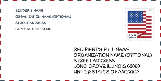
Envelope Example

This is an example of a US zip envelope. You can use a 5-digit zipcode or a detailed 9-digit zipcode to copy the mail in the following address format.
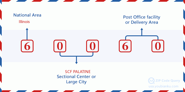
60060 Basic Meaning
What does each digit of ZIP Code 60060 stands for? The first digit designates a national area, which ranges from zero for the Northeast to nine for the far West. The 2-3 digits are the code of a sectional center facility in that region. The last two digits designate small post offices or postal zones.
Online Map

This is online map of the address Mundelein, Illinois, United States. You may use button to move and zoom in / out. The map information is for reference only.
Library

This is the ZIP Code 60060 - Library page list. Its detail Library Name, Address, City, State, ZIP Code, Phone is as below.
- Name: FREMONT PUBLIC LIBRARY DISTRICT
- Address: 1170 NORTH MIDLOTHIAN ROAD
- City: MUNDELEIN
- State: IL - Illinois
- ZIP Code: 60060
- Phone: (847) 566-8702
School

This is the ZIP Code 60060 - School page list. Its detail School Name, Address, City, State, ZIP Code is as below.
- School Name: South School
- Address: 300 N Ridgemoor Ave
- City: Mundelein
- State: IL
- Grades: UG
- ZIP Code: 60060
Population for ZIP Code 60060

What is the total population in ZIP Code 60060? Below is detail information.
- Population for ZIP Code 60060: 39,440
- 2010 Population: 37,189
The 2020 demographic statistics are in progress. The current population in ZIP code 60060 is 39,440, and the population in 2010 is 37,189.
Gender

In all the statistical population, the male population is 18,901, the female population is 18,288.
- Male Population: 18,901
- Female Population: 18,288
Race

In all the statistical population, the male population is 18,901, the female population is 18,288.
- White Population: 28,238
- Black Population: 736
- Hispanic Population: 10,741
- Asian Population: 3,291
- Hawaiian Population: 43
- Indian Population: 391
- Other Population: 5,467
Age

In all the statistical population, the White population is 28,238, the Black population is 736, the Hispanic population is 10,741, the Asian population is 3,291, the Hawaiian population is 43, the Indian Ppopulation is 391 and Other population is 5,467.
- Age's Median: 35.9
- Median of male age: 34.6
- Median of female age: 37.2
Households for ZIP Code 60060
ZIP code 60060 has 12,548 households, with an average number of 2.94 persons per household. The average income per household in Zip code 60060 is 93,108 USD, and the average house value is 250,700 USD.
- Households Per Zipcode: 12,548
- Persons Per Household: 2.94
- Average House Value: 250,700
- Income Per Household: 93,108
Geographic

The latitude of the Zip code 60060 is 42.262812, the longitude is -88.047407, and the elevation is 839. It has land area of 23.549 square miles, and water area of 1.303 square miles. The time zone for ZIP code 60060 is Central (GMT -06:00). Daylight saving time should be observed in the area where the zip code is located.
- Latitude: 42.262812
- Longitude: -88.047407
- Elevation: 839
- Land Area: 23.549
- Water Area: 1.303
- Time Zone: Central (GMT -06:00)
- Region: Midwest
- Division: East North Central
- Day Light Saving: Y
Congressional District

The Congressional District for ZIP code 60060 is Illinois's 06th|10th|14th congressional district, the Congressional Land Area is 378.78|299.78|1597.6 square mile.
- Congressional District: 06th|10th|14th
- Congressional Land Area: 378.78|299.78|1597.6
Delivery

In the ZIP code 60060, there are 13,415 residential delivery mailboxes and centralized units, and 975 commercial delivery mailbox and centralized units, 10,691 single family deliveries and 1,837 multifamily deliveries, and the box count is 15,510. The main post office has city delivery carrier routes for the ZIP code 60060.
- Delivery Residential: 13,415
- Delivery Business: 975
- Delivery Total: 15,510
- Single Family Delivery Units: 10,691
- Multi Family Delivery Units: 1,837
- City Delivery Indicator: Y
Business

In ZIP code 60060, the number of business is 1,028, the number of employee is 13,677, the business first quarter payroll is 163,607,000 USD, the business annual payroll is 734,042,000 USD.
- Number Of Businesses: 1,028
- Number Of Employees: 13,677
- Business First Quarter Payroll: 163,607,000
- Business Annual Payroll: 734,042,000
Social Security Benefits

There are 5,690 beneficiaries with benefits in current-payment status for ZIP code 60060, of which 4,440 are retired workers, 405 are disabled workers, 305 are widow(er)s and parents, 320 are spouses and 220 are children. The number of beneficiaries aged 65 or older is 4,820. The total monthly benefits are 9,134,000 USD, of which 7,590,000 USD for retired workers, 487,000 USD for widow(er)s and parents.
- Total Number: 5,690
- Retired workers Number: 4,440
- Disabled workers Number: 405
- Widow(er)s and parents Number: 305
- Spouses Number: 320
- Children Number: 220
- All beneficiaries per month: 9,134,000
- Retired workers per month: 7,590,000
- Widow(er)s and parents per month: 487,000
- Number of beneficiaries aged 65 or older: 4,820


Add new comment