ZIP Code: 66102, Kansas City, KS
ZIP Code 66102 is located in Kansas City, Kansas. Its detail State, County, City, Longitude, Latitude, Envelope Example, Population is as below.
ZIP Code 66102 Information

-
-
Country:
U.S. - United States
State:
County FIPS:
20209
City:
Area Code:
City Type ?In many cases, a ZIP Code can have multiple "names", meaning cities, towns, or subdivisions, in its boundaries. However, it will ALWAYS have exactly 1 "default" name. D - Default - This is the "preferred" name - by the USPS - for a city. Each ZIP Code has one - and only one - "default" name. In most cases, this is what people who live in that area call the city as well. A - Acceptable - This name can be used for mailing purposes. Often times alternative names are large neighborhoods or sections of the city/town. In some cases a ZIP Code may have several "acceptable" names which is used to group towns under one ZIP Code. N - Not Acceptable - A "not acceptable" name is, in many cases, a nickname that residents give that location. According to the USPS, you should NOT send mail to that ZIP Code using the "not acceptable" name when mailing.:
D (Default)
ZIP Code:
66102
❓What does D (Default) mean? This is the "preferred" name - by the USPS - for a city. Each ZIP Code has one - and only one - "default" name. In most cases, this is what people who live in that area call the city as well.
-


-
Iconic US Landmark Legacy Designs
Get PNG, SVG, EPS, AI, PDF Versions at Just $0.1
 Download Now
-


ZipCodeCraft
ZIP Code 66102 Plus 4
ZIP Code 5 plus 4 is the extension of 5-digit zip code, It can be used to locate a more detailed location. The last four digits designate segment or one side of a street or an apartment. You can find the ZIP+4 code and corresponding address of the zip code 66102 below.
| ZIP Code 5 Plus 4 | Address |
|---|---|
| 66102-1000 | 1900 N 70TH ST #00000121 , KANSAS CITY, KS |
| 66102-1000 | 1900 N 70TH ST #00000201 , KANSAS CITY, KS |
| 66102-1001 | 6500 GARFIELD AVE, KANSAS CITY, KS |
| 66102-1002 | 1900 N 70TH ST #00000200 , KANSAS CITY, KS |
| 66102-1003 | 1401 N 64TH TER, KANSAS CITY, KS |
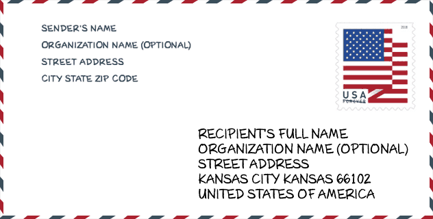
Envelope Example

This is an example of a US zip envelope. You can use a 5-digit zipcode or a detailed 9-digit zipcode to copy the mail in the following address format.
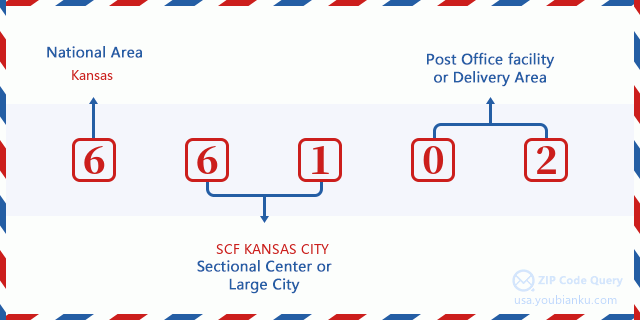
66102 Basic Meaning
What does each digit of ZIP Code 66102 stands for? The first digit designates a national area, which ranges from zero for the Northeast to nine for the far West. The 2-3 digits are the code of a sectional center facility in that region. The last two digits designate small post offices or postal zones.
Online Map

This is online map of the address Kansas City, Kansas, United States. You may use button to move and zoom in / out. The map information is for reference only.
University

This is the ZIP Code 66102 - University page list. Its detail university Name, Street, City, State, ZIP Code, Phone is as below.
| Name | Street | City | State | ZIP Code | Phone |
| Donnelly College | 608 N 18th St | Kansas City | KS | 66102 | (913) 621-6000 |
School
This is the ZIP Code 66102 - School page list. Its detail School Name, Address, City, State, ZIP Code is as below.
| School Name | Address | City | State | Grades | ZIP Code |
|---|---|---|---|---|---|
| School for Blind Elementary | 1100 State Avenue | Kansas City | KS | UG | 66102 |
| Mark Twain Elem | 2300 Minnesota Avenue | Kansas City | KS | UG | 66102 |
| McKinley Elementary School | 1301 Armstrong | Kansas City | KS | UG | 66102 |
| Gloria Willis Middle School | 1735 N. 64th Terrace | Kansas City | KS | UG | 66102 |
Population for ZIP Code 66102

What is the total population in ZIP Code 66102? Below is detail information.
- Population for ZIP Code 66102: 31,271
- 2010 Population: 29,282
The 2020 demographic statistics are in progress. The current population in ZIP code 66102 is 31,271, and the population in 2010 is 29,282.
Gender

In all the statistical population, the male population is 14,786, the female population is 14,496.
- Male Population: 14,786
- Female Population: 14,496
Race

In all the statistical population, the male population is 14,786, the female population is 14,496.
- White Population: 13,746
- Black Population: 7,741
- Hispanic Population: 13,125
- Asian Population: 1,282
- Hawaiian Population: 76
- Indian Population: 568
- Other Population: 7,081
Age

In all the statistical population, the White population is 13,746, the Black population is 7,741, the Hispanic population is 13,125, the Asian population is 1,282, the Hawaiian population is 76, the Indian Ppopulation is 568 and Other population is 7,081.
- Age's Median: 29.8
- Median of male age: 29.3
- Median of female age: 30.3
Households for ZIP Code 66102
ZIP code 66102 has 9,818 households, with an average number of 2.97 persons per household. The average income per household in Zip code 66102 is 34,410 USD, and the average house value is 65,900 USD.
- Households Per Zipcode: 9,818
- Persons Per Household: 2.97
- Average House Value: 65,900
- Income Per Household: 34,410
Geographic

The latitude of the Zip code 66102 is 39.109630, the longitude is -94.689499, and the elevation is 859. It has land area of 11.173 square miles, and water area of 0.067 square miles. The time zone for ZIP code 66102 is Central (GMT -06:00). Daylight saving time should be observed in the area where the zip code is located.
- Latitude: 39.109630
- Longitude: -94.689499
- Elevation: 859
- Land Area: 11.173
- Water Area: 0.067
- Time Zone: Central (GMT -06:00)
- Region: Midwest
- Division: West North Central
- Day Light Saving: Y
Congressional District

The Congressional District for ZIP code 66102 is Kansas's 3rd congressional district, the Congressional Land Area is 757.2 square mile.
- Congressional District: 3rd
- Congressional Land Area: 757.2
Delivery

In the ZIP code 66102, there are 10,529 residential delivery mailboxes and centralized units, and 648 commercial delivery mailbox and centralized units, 8,261 single family deliveries and 1,303 multifamily deliveries, and the box count is 11,588. The main post office has city delivery carrier routes for the ZIP code 66102.
- Delivery Residential: 10,529
- Delivery Business: 648
- Delivery Total: 11,588
- Single Family Delivery Units: 8,261
- Multi Family Delivery Units: 1,303
- City Delivery Indicator: Y
Business

In ZIP code 66102, the number of business is 413, the number of employee is 5,681, the business first quarter payroll is 46,384,000 USD, the business annual payroll is 194,738,000 USD.
- Number Of Businesses: 413
- Number Of Employees: 5,681
- Business First Quarter Payroll: 46,384,000
- Business Annual Payroll: 194,738,000
Social Security Benefits

There are 3,780 beneficiaries with benefits in current-payment status for ZIP code 66102, of which 2,265 are retired workers, 830 are disabled workers, 210 are widow(er)s and parents, 95 are spouses and 380 are children. The number of beneficiaries aged 65 or older is 2,385. The total monthly benefits are 4,462,000 USD, of which 3,023,000 USD for retired workers, 257,000 USD for widow(er)s and parents.
- Total Number: 3,780
- Retired workers Number: 2,265
- Disabled workers Number: 830
- Widow(er)s and parents Number: 210
- Spouses Number: 95
- Children Number: 380
- All beneficiaries per month: 4,462,000
- Retired workers per month: 3,023,000
- Widow(er)s and parents per month: 257,000
- Number of beneficiaries aged 65 or older: 2,385


Trabajo
Hola
Add new comment