United States ZIP Code: 66855
This is the Kansas ZIP Code 66855 page list. Its detail State, County, City, Longitude, Latitude, Envelope Example, Population is as below.

ZIP Code 66855 Information

-
-
Country:
U.S. - United States
State:
State FIPS:
20
Area Code:
ZIP Code:
66855
ZIP Type:
S (Standard)
❓What does S (Standard) mean? A "standard" ZIP Code is what most people think of when they talk about ZIP Codes - essentially a town, city, or a division of a city that has mail service.
-


-
Iconic US Landmark Legacy Designs
Get PNG, SVG, EPS, AI, PDF Versions at Just $0.1
 Download Now
-


ZipCodeCraft
ZIP Code 66855 - City

This is the city information corresponding to 66855:
| State | County | City | City Type ?In many cases, a ZIP Code can have multiple "names", meaning cities, towns, or subdivisions, in its boundaries. However, it will ALWAYS have exactly 1 "default" name. D - Default - This is the "preferred" name - by the USPS - for a city. Each ZIP Code has one - and only one - "default" name. In most cases, this is what people who live in that area call the city as well. A - Acceptable - This name can be used for mailing purposes. Often times alternative names are large neighborhoods or sections of the city/town. In some cases a ZIP Code may have several "acceptable" names which is used to group towns under one ZIP Code. N - Not Acceptable - A "not acceptable" name is, in many cases, a nickname that residents give that location. According to the USPS, you should NOT send mail to that ZIP Code using the "not acceptable" name when mailing. | ZIP Code |
|---|---|---|---|---|
| KS | Greenwood | Lamont | D (Default) | 66855 |
| KS | Greenwood | Madison | A (Acceptable) | 66855 |
❓What does D (Default) mean? This is the "preferred" name - by the USPS - for a city. Each ZIP Code has one - and only one - "default" name. In most cases, this is what people who live in that area call the city as well.
❓What does A (Acceptable) mean? This name can be used for mailing purposes. Often times alternative names are large neighborhoods or sections of the city/town. In some cases a ZIP Code may have several "acceptable" names which is used to group towns under one ZIP Code.
ZIP Code 66855 Plus 4
ZIP Code 5 plus 4 is the extension of 5-digit zip code, It can be used to locate a more detailed location. The last four digits designate segment or one side of a street or an apartment. You can find the ZIP+4 code and corresponding address of the zip code 66855 below.
| ZIP Code 5 Plus 4 | Address |
|---|---|
| 66855-0013 | PO BOX 13, LAMONT, KS |
| 66855-0571 | PO BOX 571, LAMONT, KS |
| 66855-5000 | 3490 DD20 RD, LAMONT, KS |
| 66855-5000 | 3496 DD20 RD, LAMONT, KS |
| 66855-5001 | 3475 DD30 RD, LAMONT, KS |
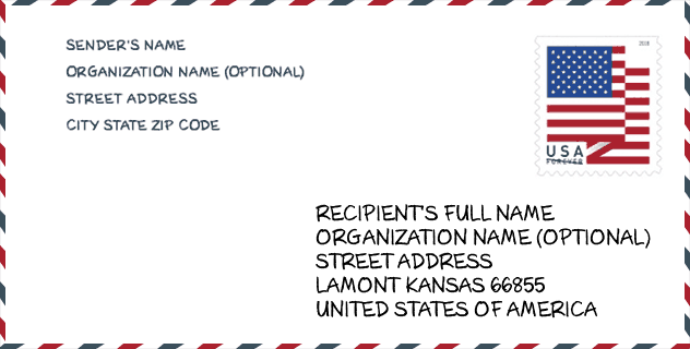
Envelope Example

This is an example of a US zip envelope. You can use a 5-digit zipcode or a detailed 9-digit zipcode to copy the mail in the following address format.
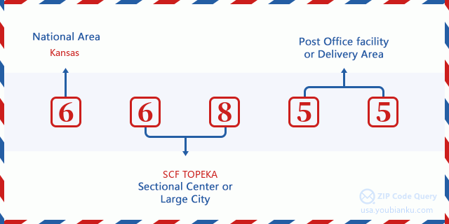
66855 Basic Meaning
What does each digit of ZIP Code 66855 stands for? The first digit designates a national area, which ranges from zero for the Northeast to nine for the far West. The 2-3 digits are the code of a sectional center facility in that region. The last two digits designate small post offices or postal zones.
Online Map

This is online map of the address Madison, Kansas, United States. You may use button to move and zoom in / out. The map information is for reference only.
Population for ZIP Code 66855

What is the total population in ZIP Code 66855? Below is detail information.
- Population for ZIP Code 66855: 9
- 2010 Population: 0
The 2020 demographic statistics are in progress. The current population in ZIP code 66855 is 9, and the population in 2010 is 0.
Geographic

The latitude of the Zip code 66855 is 38.112800, the longitude is -96.026700, and the elevation is 1127. It has land area of 0 square miles, and water area of 0 square miles. The time zone for ZIP code 66855 is Central (GMT -06:00). Daylight saving time should be observed in the area where the zip code is located.
- Latitude: 38.112800
- Longitude: -96.026700
- Elevation: 1127
- Land Area: 0
- Water Area: 0
- Time Zone: Central (GMT -06:00)
- Region: Midwest
- Division: West North Central
- Day Light Saving: Y
Congressional District

The Congressional District for ZIP code 66855 is Kansas's 04th congressional district, the Congressional Land Area is 14315.68 square mile.
- Congressional District: 04th
- Congressional Land Area: 14315.68
Delivery

In the ZIP code 66855, there are 4 residential delivery mailboxes and centralized units, and 0 commercial delivery mailbox and centralized units, 4 single family deliveries and 0 multifamily deliveries, and the box count is 18. The main post office does not have city delivery carrier routes for the ZIP code 66855.
- Delivery Residential: 4
- Delivery Business: 0
- Delivery Total: 18
- Single Family Delivery Units: 4
- Multi Family Delivery Units: 0
- City Delivery Indicator: N


Add new comment